Download
1 / 23
230 likes | 704 Views
GPS Space Service Volume Increasing the Utility of GPS for Space Users Michael C. Moreau, Ph.D. Flight Dynamics Analysis Branch NASA Goddard Space Flight Center October 16, 2008 Outline Background on use of GPS in High Earth Orbits Space Service Volume Definition and Characteristics

E N D
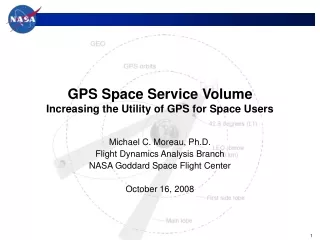
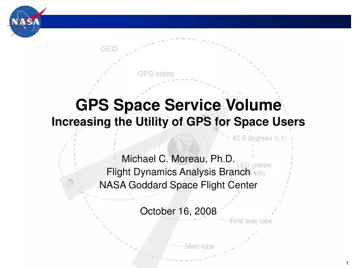
GPS Space Service VolumeIncreasing the Utility of GPS for Space Users Michael C. Moreau, Ph.D. Flight Dynamics Analysis Branch NASA Goddard Space Flight Center October 16, 2008
Outline • Background on use of GPS in High Earth Orbits • Space Service Volume Definition and Characteristics • NASA flight experiment (AO-40 satellite) • Results and observations • Evolving Space User Requirements • Updated GPS III Space User Requirements • Pseudorange accuracy • Received power • Signal availability • Closing Remarks
Background • GPS availability and signal strength requirements for PVT services originally specified for users on or near surface of Earth • Primarily Land, Air, & Maritime users • Transmitted power levels specified at edge-of-Earth, 14.3 degrees • NASA and DoD space programs increasingly rely on GPS for spacecraft navigation • Most space users in Low-Earth Orbits (below 3000 km) • Strong interest in the use of GPS in high altitude orbits. • NASA “high altitude” GPS activities have included: • Conducting flight experiments to characterize GPS performance • Development of new GPS receivers for spacecraft in Geostationary or highly elliptical orbits • Working with the GPS Wing to formally document GPS requirements for space users
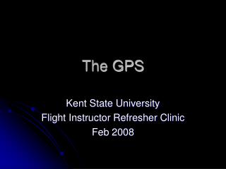
First Side Lobes First Side Lobe Reception Geometry for GPS Signals in Space HEO Spacecraft Geosync Altitude: 35,887 km LEO Altitudes < 3,000 km 3,000 km GPS Altitude: 20,183 km Main Lobe (~47° for GPS L1 signal)
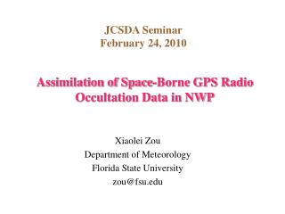
GEO Altitude - 36,000 km GPS Altitude - 20,183 km Terrestrial and Space Service Volumes Terrestrial Service Volume Surface to 3,000 km Space Service Volume (High/Geosynchronous Altitudes) 8,000 to 36,000 km Space Service Volume (Medium Altitudes) 3,000 to 8,000 km
Terrestrial Service VolumeLEO (≤ 3,000 km) Characteristics • PVT performance consistent with that enjoyed by terrestrial users • Uniform received power levels • Fully overlapping coverage of GPS main beams • Nearly 100% GPS coverage • Instantaneous navigation solutions
Space Service VolumeMedium Altitudes (3,000 – 8,000 km) Characteristics • Four GPS signals available simultaneously a majority of the time • Conventional space GPS receivers will have difficulty: • GPS signals over the limb of the earth become increasingly important • Wide range of received GPS signal strength • One-meter orbit accuracies feasible
Space Service VolumeHEO/GEO (8,000 – 36,000 km) Characteristics • Nearly all GPS signals received over the limb of the Earth • Users will experience periods when no GPS satellites are available • Received power levels will be weaker than those in TSV or MEO SSV • Properly designed receiver should be capable of accuracies ranging from 10s of meters to 100s of meters, depending on receiver sensitivity and local oscillator stability.
High Earth Orbit GPS Timeline Capability Description Document for GPS III includes updated Space Service Volume definition and requirements Feb, 2000 version of GPS Operational Requirements Document (ORD) includes first requirements for Space Service Volume 2000 2010 1990 Many civil and military missions with plans for operational use of GPS in high altitude orbits… EQUATOR-S, TEAMSAT, Falcon Gold flight experiments GIOVE A Kronman paper published on DoD mission using GPS in GEO orbit STENTOR (GEO) mission lost to launch vehicle failure NASA/AMSAT AO-40 flight experiment STRV1-D mission lost to launch vehicle failure
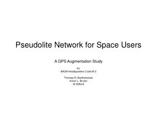
AMSAT-OSCAR 40 (AO-40) Experiment TANS Vector Receiver AO-40 Spacecraft High Gain Antenna (1 of 4)
AO-40 Measured -vs- Predicted Antenna Gain data from II/IIA satellites follows predictions IIR data has steeper drop-off of main lobe signals, but higher side lobes • Comparison of AO-40 measurements and predicted GPS satellite antenna gain (mean Block II/IIA) • AO-40 data detected significant differences in gain patterns on new Block IIR satellites - side lobes were significantly higher than expected
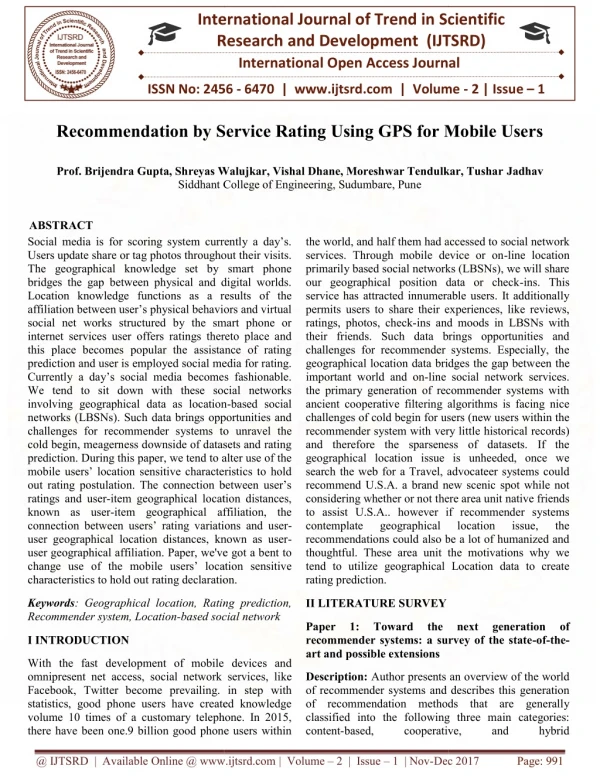
Simulated GPS L1 C/A Availability for GEO user–182 dBW threshold, IIR antenna Main lobes only (within 23.5 degrees) All signals above –182 dBW 4 or more SVs visible: 2% 2 or more SVs visible: 31% no SVs visible : 39% 4 or more SVs visible: 100% 2 or more SVs visible: 100% no SVs visible : 0% AO-40 data affirmed GPS side lobe signals significantly improve signal availability
“High Altitude GPS” Observations • On-orbit performance of GPS varied from block build to block build (IIA, IIRM, expected IIF) due to antenna gain variances • Side-lobe signals, although not specified, can significantly boost GPS signal availability for users above the constellation • During GPS III Phase A, NASA noted significant discrepancies in power levels specified in GPS III specification documents, and measured on-orbit performance • To stabilize signal for high altitude space users, created new Space Service Volume (SSV) definition and specifications • Guarantee backward compatibility • Identify areas for improved performance through objective requirements
SSV Requirements for GPS III • Users in the SSV cannot typically rely on conventional, instantaneous GPS solutions • Performance requirements established via three parameters • Pseudorange accuracy • Received power • Signal availability
Evolving Space User Requirements • Established two operational volumes • Terrestrial Service Volume (TSV) • Earth surface to 3,000 km altitude • Space Service Volume (SSV) • 3,000 km to 36,000 km (~GEO) altitude • Signal availability and power defined only for geostationary equatorial users • Minimum performance specified corresponding to a 23.5º GPS transmitter half angle • Shortcomings of ORD space user requirements: • Did not cover mid-altitude users (above LEO but below GPS) • Did not cover users outside of the equatorial plane • Only specified reqts on L1 signals (L2 and L5 have wider beam-width and therefore, better coverage) GPS IIF Operational Requirements Document (ORD) (ca. 2000)
GPS III Capability Development Document (CDD) Evolving Space User Requirementscontinued • Threshold requirements specifically document current system performance • Divided Space Service Volume into two regions • Medium Earth Orbit (MEO) SSV • 3,000 km to 8,000 km altitude • High Earth Orbit / Geostationary Earth Orbit (HEO/GEO) SSV • 8,000 km to 36,000 km altitude • Minimum performance specified at23.5° (L1) and 26° (L2/L5) GPS transmitter antenna half-angles • Objective requirements also defined • Objective signal availability consistent with current performance if side-lobe signals are considered.
SSV Pseudorange Accuracy • Also known as User Range Error (URE) • Error bound on GPS range measurement • Function of • Accuracy of GPS orbit and clock solutions from Control Segment • Age of Data • Uncertainty in GPS physical and modeling parameters • Antenna group delay and phase errors vary as a function of off-nadir angle • Current performance ≈ 1 meter • GPS III requirement: ≤ 0.8 meter (rms) • GPS III objective: ≤ 0.2 meter (rms)
GPS III Minimum Received Signal Power (dBW) Requirement • SSV minimum power levels were specified based on the worst-case (minimum) gain across the Block IIA, IIR, IIR-M, and IIF satellites • Some signals have several dB margin with respect to these requirements at reference half-beamwidth point
GPS III Minimum Availability Requirement • Assuming a nominal, optimized GPS constellation and no GPS spacecraft failures, signal availability at 95% of the areas at a specific altitude within the specified SSV are planned as: • Objective Requirements: • MEO SSV: 4 GPS satellites always in view • HEO/GEO SSV: at least 1 GPS satellite always in view
Example NASA Application: GPS Tracking for Lunar Missions • Weak GPS signal tracking technology enables tracking of GPS signals well beyond the GPS constellation sphere • GPS can potentially improve navigation accuracy in the 12-24 hours preceding Earth entry interface Periods or 2 or more GPS available35 dB-Hz sensitivityEI – 2 hrs GPS altitudeEI – 1.2 hrs Ground Updates Final Correction Burn, EI-5 hrs Periods 2 or more GPS available25 dB-Hz sensitivityEI – 12 hrs Correction BurnEI-16 hrs
Closing Remarks • NASA and other space GPS users rely on GPS as critical component of space navigation infrastructure over expanding range of orbital applications • NASA’s Space Communications and Navigation Architecture relies heavily on GPS • Space user community was vulnerable to design changes because requirements were not explicitly stated • Space user requirements identified by volumes based on altitude • Terrestrial Service Volume (TSV): surface to 3,000 km • Space Service Volume (SSV) • Medium Earth Orbit (MEO): 3,000 to 8,000 km • High Earth Orbit / Geostationary Earth Orbit (HEO/GEO): 8,000 to 36,000 km • New requirements baselined as part of GPS III: • Maintains backward compatibility with current constellation • Identifies potential areas for improved performance through objective requirements • Provides a green-light for civil and military space missions considering operational use of GPS beyond LEO • Interoperability for all space users will be enhanced if other PNT service providers such as Galileo also implement similar requirements/operational capabilities.
References F.H. Bauer, M.C. Moreau, M.E. Dahle-Melsaether, W.P. Petrofski, B.J. Stanton, S. Thomason, G.A Harris, R.P. Sena, L. Parker Temple III, The GPS Space Service Volume, ION GNSS, September 2006. M.Moreau, E.Davis, J.R.Carpenter, G.Davis, L.Jackson, P.Axelrad, “Results from the GPS Flight Experiment on the High Earth Orbit AMSAT AO-40 Spacecraft," Proceedings of the ION GPS 2002 Conference, Portland, OR, 2002. Kronman, J.D., "Experience Using GPS For Orbit Determination of a Geosynchronous Satellite," Proceedings of the Institute of Navigation GPS 2000 Conference, Salt Lake City, UT, September 2000. These and other NASA References can be found here: http://www.emergentspace.com/related_works.html