Download
1 / 3
30 likes | 34 Views
Aerial & Satellite Image Analytics (SIA) Platform uses computer vision & object detection. Aventior offers the SIA platform depending on client needs.<br>

E N D
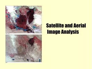
Aerial and Satellite Image Analysis Using Computer Vision and AI Aerial & Satellite Image Analytics (SIA) Platform uses computer vision and object detection, to monitor changes to urban areas, count vehicles, and map open spaces. Some of the applications include Buildings detection, Sport-Facilities detection, Vehicles detection, and Ships and Airplanes detection. Applications of these range from urban planning & monitoring, construction, energy & utilities, traffic management, intelligence & reconnaissance. The SIA platform is capable of processing aerial and satellite imagery in RGB mode and is capable of processing images and videos that have 55 cm or less in resolution (Ground Sampling Distance - GSD). The source of images could be Low Earth Orbit (LEO) satellites, High-Altitude Pseudo Satellites (HAPS), Aircraft, drones/UAVs. Aventior offers the SIA platform in multiple models depending on client needs. These include SaaS-based access, API based data service, and Product embedding. A consumer version of the key SIA algorithms is also available through our partner platforms such as UP42 (www.up42.com) and Esri (www.esri.com). Applications Building Detection Using the Building Detection module within SIA, organizations can classify and count buildings in an urban location. It is capable of running the detection algorithm at a large scale to cover areas over 100 square kilometers. Urban planners can use this platform to detect changes over a period of time, measure modifications and extensions to houses, count apartments for the census, and determine the quality of infrastructure. Retail and telecommunication companies can use this to determine market density, logistics. Additional applications: Building Detection, Apartments Detection, House Detection, Urban Planning, Construction, Change detection, illegal construction monitoring, census and population, urban planning, solar power potential, ad and billboard placement, first responders, police, law enforcement, emergency routes. Sports Facilities Detection Detect sports facilities like soccer fields, baseball parks, tennis courts and stadiums. Urban planners can use this information to understand use of open spaces, planning of recreational spaces and entertainment facilities. Governments, real estate developers, private equity funds can use this data to measure urban development, facility usage and earning potential. Ad companies can determine best locations to place billboards, run ad campaigns. Real estate developers, food
companies can determine placement of eateries, complementary services and earning potential. First responders, public safety officers, and law enforcement can map access points, do crowd management and design emergency routes. Vehicle Detection SIA has an inbuilt capability to detect small and large vehicles in urban, rural, and industrial settings. It has the capability to classify vehicles, provide counts, and geo-coordinates. Counting, classifying, and tracking vehicles can be used by hedge fund investors to determine economic activity, retailers to track actual sales, mining companies to manage heavy machinery and assets, customs and border protection to monitor border activities, urban planners to manage traffic and illegal parking. Urban Super Resolution (USR) The Urban Super Resolution is an image enhancement processing powered by AI. The USR module within SIA is an image per-processing sub routine that has been configured to process images of cities, towns and suburban locations to improve the Ground Sampling Distance (GSD). It is an effective alternative to image enhancement that uses heuristics instead of commonly used weighted algorithms. The SIA platform’s USR is capable of improving the image resolution by 4X. Common applications are around improving the resolution of 70 cm GSD images to 17.5 cm and 50 cm GSD images to 12.5 cm. Human Detection The SIA has been modified to also process drone footage (4K images and videos). One of the primary applications has been around human detection for search and rescue and for homicide investigation. This is particularly effective for relatively open areas, desert, mountainous and urban locations. With the primary users being local police, sheriff and custom & border protection agencies to help locate missing individuals and victims. Maritime Surveillance The SIA platform can be used to detect ships, flotilla, oil tankers and other vessels in open seas, harbors and ports. This data can be then merged with real-time AIS data to ensure validity of vessels in the open ocean, ensure safety of cargo operations, sailor safety, anti-piracy and environment protection. Law enforcement and security agencies can feed drone videos or high-altitude pseudo satellite (HAPS) data to gather situational awareness on a real-time basis.
Additional predictive modeling can be used to model ship movement to avoid port congestion. Aircraft Detection Aircraft detection module helps locate, track and count aircrafts on the ground (airports and hangars). It can be used to determine economic activities - important for investors in the travel, transportation and logistics industry. Airports and aircrafts are strategic assets and information to track such data is key for surveillance and intelligence. Power Line Inspection and Anomaly Detection Power infrastructure such as power poles and power lines pose safety challenges for inspectors. A typical power line and transmission pole inspections are carried out using aerial platforms such as airplanes and helicopters. These methods are expensive and unsafe. Increasingly, utility companies are using drones to facilitate large scale inspection. SIA’s module for power line detection, inspection and anomaly detection provides a faster AI based processing of drone feeds that reduces the processing time significantly.