Download
1 / 30
310 likes | 1.11k Views
All Hazards & Emergency Support. National Weather Service Springfield, Missouri Andy Foster & Drew Albert WFO Springfield MO. WFO All Hazards Support. Provide mission specific weather information to support strategic and tactical decisions where and when it is needed. .

E N D
All Hazards & Emergency Support National Weather Service Springfield, Missouri Andy Foster & Drew Albert WFO Springfield MO
WFO All Hazards Support Provide mission specific weather information to support strategic and tactical decisions where and when it is needed.
WFO All Hazards Support All hazards support especially important in high impact events. What is a high impact event? "A human-made or natural circumstance, often hazardous, and dependent upon or sensitive to weather and water. Significant events usually affect large numbers of people, generate media interest, and their nature is such that the NWS has, or can quickly develop, environmental expertise to provide service to mitigate the hazard."
WFO All Hazards SupportLocal Incidents Incident command teams for regional emergencies have been established for ice storms (Jan and Dec 2007), Missouri River Flooding (May 2007), large prescribed fires, tornado recovery, etc. WFO staff have been dispatched to some of these incidents/incident command posts
WFO All Hazards SupportChallenges • Staffing & Resource Allocation • Communications – Internet, etc. • Funding – Travel, mileage, salary, etc. • Training ICS 100/200/700, S-290/390. • Equipment – communications, monitoring software, protective clothing, • Local Policy – When and where to deploy? • Partnerships – need to build relationships • Weather information timeliness and availability
WFO All Hazards SupportThe Plan • WFO Springfield presently spinning up incident command support. • Goal is to support the Missouri State Emergency Management Agency (SEMA) • Primary support through WCM and staff members who have received preliminary training (ICS 100/200/700, S-290, etc). • Get Equipped - Laptop with wireless capability, belt weather kit and or Kestrel unit. Possible use of USB Flash Drive? Graphics/presentation software, GIS, etc.
WFO All Hazards SupportSolutions Implement properly equipped NWS into the ICS command structure. Properly equip for monitoring weather data and forecasts Develop effective means of communication- conference calls, internet, etc. Mission focused.
WFO All Hazards SupportOnsite Onsite meteorologist acts as liaison between WFO and agency. The meteorologist represents the WFO and presents a tailored WFO forecast for specific mission needs. Utilize internet graphics from the WFO (Radar, news stories, etc.) Utilize weather display software Utilize GIS viewers Document EVERYTHING. Be prepared to brief at anytime. Be flexible.
WFO All Hazards SupportOnsite - Communications Text message software. Pidgin Software http://www.pidgin.im/ Cross Platform. Can monitor multiple chat platforms. SGF utilizes both America Online (AOL) Instant Messenger and a Jabber (open source instant message protocol) to chat within the IEMChat Project conference boards. https://iemchat.com/ Chat with WFOs, monitor watch /warning/ advisories. HAM, TRS
WFO All Hazards SupportOnsite - Software • BUFKIT - BUFKIT is a forecast profile visualization and analysis tool kit developed by the staff at the National Weather Service (NWS) office in Buffalo and the Warning Decision Training Branch (WDTB) in Norman, OK. http://www.wbuf.noaa.gov/bufkit/bufkit.html • Weather Monitoring: Digital Atmosphere • http://www.weathergraphics.com/da/ • Download surface data, radar, watch/warning data. • Develop and display maps of data in real time. • Customizable maps. • Excellent for weather monitoring local weather. Displays mesonet, RAWS, any stations in the Meteorological Assimilation Data Ingest System (MADIS).
WFO All Hazards SupportOnsite - Portable Office • Standard office software (Microsoft or OpenOffice (http://www.openoffice.org/) • Snagit screen capture and software editor. (http://www.techsmith.com/) • For a USB memory stick, PortableApps.com • Can carry around browser, office suite, documentation, etc on a memory stick. Good tool when you only have access to the Internet through other personal computers. • Can carry your own references, manuals, EF Scale reference for tornado surveys, station duty manual, etc.
WFO SGF All Hazards SupportProducts & Services Further development of products and services needed to support decision needs of our customers. More specific mission critical information Confidence Level Risk Factor & Analysis Impact Assessment PIO IMET
WFO All Hazards SupportProducts & Services Products and services need to be enhanced to provide specific mission critical information.
WFO All Hazards SupportProducts & Services All Hazards Support through All Phases of an Event
WFO All Hazards SupportProducts & Services Graphical Web Products Designed to Support User Decisions Graphical HWO’s / Decision Support Graphics
WFO All Hazards SupportProducts & Services Graphical Web Products Designed to Support User Decisions Briefing Pages / Weather Information Suites
WFO All Hazards SupportProducts & Services Graphical Web Products Designed to Support User Decisions Media Briefings / Weather Information Packages
WFO All Hazards SupportProducts & Services Graphical Web Products Designed to Support User Decisions Video Briefings
WFO All Hazards SupportGIS Viewers and Products • Utilize GIS viewers to enhance NWS services • Create map farms that provide formats that integrate with multiple GIS viewers • Provide tailored maps to EM’s, government agencies and other WFO’s. • Allow non-GIS users to work with maps. • Provides users with the “big picture”. • User questions are inherently answered
WFO All Hazards SupportWhy GIS? • Used as a planning tool for emergency planners • Provides common operating infrastructure that can be utilized between departments and multiple levels of government. • Visual information dissemination & analysis tool • Map of potential hazards • Impact analysis • Infrastructure & high impact facilities at risk • What if map
WFO All Hazards SupportWhy GIS? • Two categories of maps: • “Big Picture” –Provide situational awareness for Incident Commanders and other decision makers at the SEOC and County EOC’s. • “Customized” –Provided First Responders and Emergency Staff who were in forward locations with mission critical maps. • GIS can be applied to strategic & tactical objectives
WFO All Hazards SupportGIS Tools • GIS Tools • ArcView • ArcReader • ArcExplorer • Google Earth • Virtual Earth • Provides an easy-to-use GIS platform. • Can be very useful in internal NWS operations • Enables the NWS to provide enhanced products and services that integrate meteorological and GIS data • GIS enhanced datasets can be very useful during severe or other high impact weather events where the integration of GIS information is especially helpful.
WFO All Hazards SupportGIS Tools • Radar & Satellite • Warning Polygons • Severe Reports • Spotters/Verification • Impact assessment • Flash flood / Hydro • Fire Weather • Obs. Sites/COOP • Aviation • Climate • Situational Awareness GIS benefits operational and user needs
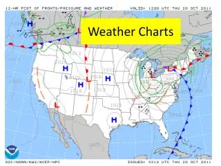
WFO All Hazards Support GIS Tools • Impact and risk assessment • Radar & Warning Polygons Integrating radar data and warning polygons with geographical layers promotes situational awareness and provides an effective means of potential impact assessment. RIDGE radar and warning polygons to KMZ/KML files. www.srh.noaa.gov/ridge/kmzgenerator.htm
WFO All Hazards SupportGIS Tools • Integrate locally created maps Flood prone locations and low water crossings
WFO All Hazards SupportGIS Tools • NDFD – Hazard Grids?
WFO All Hazards SupportGIS Tools Hysplit NESDIS Hazardous Mapping System (http://www.ssd.noaa.gov/PS/FIRE/)
WFO All Hazards SupportGIS Tools • Collective storm reports & survey results • Serve government agencies, emergency management, media & the general public with a detailed regional hazard maps. • Provide a consistent one stop location for the graphical depiction of severe weather events • Assist post storm impact assessment and recovery efforts by the emergency management community, and local, state, and federal agencies such as FEMA and Homeland Security • Effectively representing the impact of severe weather to the public and highlighting why the NWS exists. • Support WFO's and the scientific community in post event analysis. • Meeting the demand for graphics from local and national media.
WFO All Hazards Support Andy Foster WFO Springfield, Missouri