Download
1 / 1
10 likes | 116 Views
MET-8 Band Number. Central WL ( m). N. Tbb With AIRS Spectral Gaps (K). Tbb With AIRS Spectral Gaps Filled (K). 4. 4.2. 7. -2.5. -2.5. 5. 6.2. 7. -7.0. -3.2. 6. 7.3. 7. -0.9. -0.2. 7. 8.7. 7. 0.4. 1.1. 8. 9.7. 7. -0.2. 0.1. 9. 10.8. 7. 0.4. 0.5. 10.

E N D
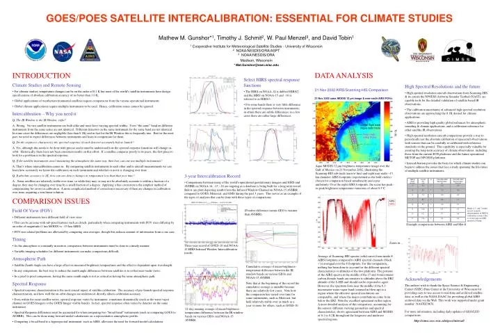
MET-8 Band Number Central WL (m) N Tbb With AIRS Spectral Gaps (K) Tbb With AIRS Spectral Gaps Filled (K) 4 4.2 7 -2.5 -2.5 5 6.2 7 -7.0 -3.2 6 7.3 7 -0.9 -0.2 7 8.7 7 0.4 1.1 8 9.7 7 -0.2 0.1 9 10.8 7 0.4 0.5 10 12.1 7 0.7 0.6 11 13.4 7 0.3 0.5 21 Nov 2002 case. MODIS 12 m image & near-nadir AIRS FOVs: Texas Gulf of Mexico aircraft flight track (Aqua nadir track) Tb (K) Near nadir AIRS FOVs S-HIS FOR GOES/POES SATELLITE INTERCALIBRATION: ESSENTIAL FOR CLIMATE STUDIES Mathew M. Gunshor*1, Timothy J. Schmit2, W. Paul Menzel3, and David Tobin1 1 Cooperative Institute for Meteorological Satellite Studies - University of Wisconsin 2 NOAA/NESDIS/ORA/ASPT 3 NOAA/NESDIS/ORA Madison, Wisconsin * Mat.Gunshor@ssec.wisc.edu DATA ANALYSIS INTRODUCTION • Select HIRS spectral response functions • The HIRS on NOAA-14 is dubbed HIRS/2 and the HIRS on NOAA-15 and –16 is referred to as HIRS/3. • For some bands there is very little difference in the spectral response between instruments; in others there are subtle differences; in a few cases there are rather large differences. • Climate Studies and Remote Sensing • For climate studies, temperature changes can be on the order of 0.1 K but most of the world’s satellite instruments have design specifications of absolute calibration accuracy of no better than 1.0 K. • Global applications of weather/environmental satellites require comparisons from the various operational instruments. • Global climate applications require multiple instruments to be used. Hence, calibration issues cannot be ignored. • Intercalibration – Why you need it • Q: The IR Window is the IR Window, right? • A: Wrong. No two satellite instruments are built alike and most have varying spectral widths. Even “the same” band on different instruments from the same series are not identical. Different detectors on the same instrument for the same band are not identical. In some cases the differences are negligible (less than 0.1K) and in fact for the IR Window this is frequently true. But for the most part, we need to expect differences between instruments and learn to compensate for them. • Q: Do the engineers characterize the spectral response of each detector accurately before launch? • A: Yes, although this needs to be done with precise and it must be understood how the spectral response functions will change in-orbit. Historically, there have not been consistent results on this effort. If a satellite compares poorly to its peers, the first place to look for a problem is in the spectral response. • Q: If the satellite instruments aren’t measuring the atmosphere the same way, then how can one use multiple instruments? • A: That’s where intercalibration comes in. By comparing satellite instruments to each other and to aircraft measurements we can learn how accurately we know the calibration on each instrument and whether or not it is changing over time. • Q: If absolute accuracy is 1K, how can one detect changes in temperature less than that over time? • A: Some satellites are relatively stable over time, so while they may or may not be absolutely accurate to within a fraction of a degree, they may be changing over time by a small fraction of a degree. Applying a bias correction is the simplest method of compensating for errors in calibration. A more complicated method of correction is necessary if there are changes in calibration over time, requiring a non-linear solution. • High Spectral Resolutions and the future • High spectral resolution aircraft observations from Scanning-HIS, & its cousin the NPOESS Airborne Sounder Testbed (NAST), are capable tools for the detailed validation of satellite based IR observations. • The calibration uncertainty of advanced high spectral resolution observations are approaching the 0.1K desired for climate applications. • AIRS is providing high quality global radiances for atmospheric sounding & climate applications, and a calibration reference for other satellite IR observations. • High spectral resolution aircraft comparisons provide a way to periodically test the absolute calibration of spacecraft observations with sensors that can be carefully re-calibrated with reference standards on the ground. This capability is especially valuable for assuring the long-term accuracy of climate observations, including those from the current EOS platforms and the future operational METOP and NPOESS platforms. • Intercalibration provides the basis for which climate studies can begin to address the issues that face a study spanning the life-times of multiple satellite instruments. 21 Nov 2002 AIRS/Scanning-HIS Comparison Aqua MODIS 12 m brightness temperature image over the Gulf of Mexico on 21 November 2002, illustrating the Scanning-HIS sub-track (narrow line) and eight near nadir ~15 km diameter AIRS footprints (represented as the bold circles) chosen for comparison based simultaneity and scene uniformity. Over the eight AIRS footprints, the scene has peak-to-peak brightness temperature variations of about 0.5°C. • 3-year Intercalibration Record • Comparisons between many of the world’s operational geostationary imagers and HIRS and AVHRR on NOAA-14, -15, -16 are ongoing as a database is being built for a long term record. Below are plots depicting results from the Infrared Window Channel on NOAA-15 AVHRR compared to GOES, Meteosat, and GMS during the past 3 years. This serves as an example of the types of analyses that can be done with these types of comparisons. COMPARISON ISSUES AIRS SHIS Bands 4, 5, and 7 results are not accurate measurements of MET-8 calibration accuracy due to severe gaps in AIRS spectral coverage • Field Of View (FOV) • Different instruments have different field of view sizes • This can be an issue with sub-pixel features such as clouds, particularly when comparing instruments with FOV sizes differing by an order of magnitude (1 km MODIS vs ~15 km AIRS) • FOV-size related problems are alleviated by comparing area averages, though this reduces amount of information from a one case. • Timing • As the atmosphere is constantly in motion, comparison between instruments must be done in a timely manner. • Variable imaging schedules for different instruments can make comparisons difficult. • Atmospheric Path • Satellite Zenith Angle can have a large effect on measured brightness temperatures and the effect is dependent upon wavelength. • In any comparison, the best way to reduce the zenith angle differences between satellites is to collect near-nadir views. • In a pixel to pixel comparison, having the same zenith angle is not as critical as having the same atmospheric path. • Spectral Response • Spectral response characterization is the most crucial aspect of satellite calibration. The accuracy of pre-launch spectral response characterization, and how well the on-orbit changes are understood, directly affects calibration accuracy. • Even within the same satellite series, spectral response varies by instrument, sometimes dramatically (such as the water vapor channel on GOES Imagers or the GOES Imager visible bands). In fact, spectral response often varies by detector on the same instrument. • Spectral Response differences must be accounted for when comparing two “broad-band” instruments (such as comparing GOES to AVHRR). This can be done using forward model calculations on a representative atmospheric profile. • Comparing a broad-band to a hyperspectral instrument, such as AIRS, alleviates the need for forward model calculations. (Positive difference means GEO is warmer than AVHRR). Example comparisons between AIRS and Met-8 Zoom in… Three-year record of GOES-10 and NOAA-15 HIRS Infrared Window Intercalibration results. Average of Scanning-HIS spectra (solid curve) from inside 8 AIRS footprints compared to AIRS spectral channels (black +’s) averaged over the 8 footprints. For this comparison, nothing has been done to account for the different spectral characteristics or altitudes of the two platforms. The portions of the AIRS spectra in the middle of the 15 and 4-micrometer carbon dioxide bands are sensitive to altitudes above the ER2 altitude of the S-HIS and should not be expected to agree. However, the spectrum from near the middle of the 6.3-micrometer water vapor band (zoomed in blow-up) is a region where the effective spectral resolutions are comparable, and where the major contributions come from below the ER2. Note the excellent agreement in this region. A more detailed analysis of this comparison, accounting for the sensors' different viewing geometries and spectral characteristics, shows agreement between AIRS and MODIS of 0.1 to 0.2K throughout the longwave and midwave spectral regions. Cumulative average of mean-brightness-temperature difference between the IR window bands on various GEOs and NOAA-15 AVHRR. Note that at the beginning of the record the cumulative average is unstable because there are relatively few cases. Note how the comparison has varied over time for some instruments, such as Meteosat, but held relatively stable over as much as a year or more for others, such as GOES-10. Acknowledgements The authors wish to thank the Space Science & Engineering Center (SSEC) Data Center at the University of Wisconsin for providing easy-to-use access to real-time and archived satellite data; as well as the NASA DAAC for providing global AIRS archived data via the Web. This work was supported under grant number: NA07EC0676. 21-day running average of mean-brightness-temperature difference between the IR window bands on various GEOs and NOAA-15 AVHRR. For more information, including daily updates of GEO/LEO comparisons: http://cimss.ssec.wisc.edu/goes/intercal/