Download
1 / 11
110 likes | 595 Views
Drawing. Design. Import/Export. Communication. Machine control. Machine guidance. Datalogging ... with coordinates roadlines and drawings both numerical and graphical. ...

E N D
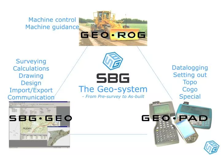
Machine control Machine guidance Surveying Calculations Drawing Design Import/Export Communication Datalogging Setting out Topo Cogo Special The Geo-system - From Pre-survey to As-built
GPS system for excavators 3D machine control
A field surveying software. When you want your instrument to be online with coordinates roadlines and drawings both numerical and graphical.
Site Navigator GeoPad with GPS for orientation and planning. Perfect for foremen and project managers. Chainage and offset Cross sections AutoCad drawings Low price and no cables
GPS system for excavators
3D machine control
Topcon system/4 Topcon system/5 Mikrofyn ScreedPro Concrete paver BladePro Road line model Gravel placer Novatron Road desc model Asphalt paver Createch Point reference DTM Base line Height reference Milling machine BPS Grid model Payloader 3B6 Help models Trimmer Wirtgen Road surveyor Serial DWG/DXF Topcon TS5 Rail surveyor GSM LandXML Plasser&Theurer Sleeper exc. mach CAN Bus ASCII AnPakke Prolec Sleeper layer USB Excel SBG Light bar Tamping mach Radio LAN Leica TPS Excavator Topcon AP-L1 Dozer Geodimeter 140T Grader Leica GPS Echo sounder Trimble ATS Pos.dir.sensor Topcon GPS Ashtech Trimble GPS GeoTracer Models Hydraulics Machines Import/Export Communication Models Positioning sensors
3D machine control system One touch operation Graphical views 3D View Automatic data logging GPS skyplot Volume calculations Background drawings
CMI Concrete Paver / 4xLeica 1100TCA – WSO Sidney, Australia