Download
1 / 77
770 likes | 773 Views
Learn about the jet stream, a narrow current of strong winds in the midlatitude tropopause. Discover its characteristics, effects on weather, and its association with temperature gradients and air masses.

E N D
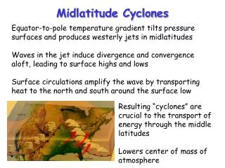
Jet Stream A jet stream (or jet) is a narrow current of strong winds. Can exist at several levels, but most often applied to the high velocity winds in the vicinity of the midlatitude tropopause
Midlatitude Jet Stream Facts • Can reach 250 mph (or more) • Centered on the upper troposphere…around 250 hPa (30,000 ft) • Stronger in winter. Generally, weakens and moves northward during summer. • Closely associated with a tropospheric temperature gradient (thermal wind!) • Not uniform zonally
Strahlstromung (German) for “jet stream” first used in 1939 • Big effects on bomber flights during WWII
Main Upper Tropospheric Jets Closely Associated with the Tropopause
http://itg1.meteor.wisc.edu/wxwise/AckermanKnox/chap7/subtropical_jet.htmlhttp://itg1.meteor.wisc.edu/wxwise/AckermanKnox/chap7/subtropical_jet.html
The Jet Stream The Jet Stream results from temperature gradients 500 mb 700 mb 850 mb Psurface Warm Cold
Where air masses of differing temperatures come together, we see fronts
Fronts An Important Midlatitude Weather Feature
Definition You Should NEVER Forget A front is a boundary between relatively uniform warm air and a zone in which temperatures cools rapidly
As a front passes there are changes in: • Temperature • Dew point • Wind direction • Pressure • cloudiness
Fronts and PressureFronts are associated with troughs of low pressure
Cold Front • Slope ~1:50, moves fast (20-30 mph), convection on leading edge
Warm Front • Smaller slope (~1:200), slower (1—15 knots), more stratiform clouds
Stationary Front similar structure to warm front, but without movement