Download
1 / 18
180 likes | 183 Views
This article discusses the issues faced with GIS data-sharing standards, specifically regarding digital parcel map data. It provides a perspective from the local assessor's office and the local GIS manager, as well as insights from a private/public perspective. The article covers topics such as re-projecting maps, joining GIS to tax rolls and commercial tax records, naming conventions, and common practices.

E N D
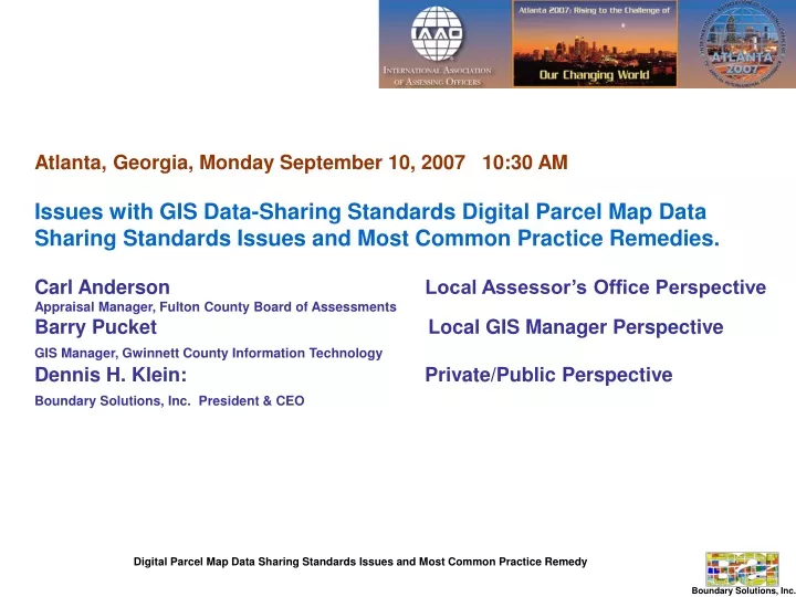
Atlanta, Georgia, Monday September 10, 2007 10:30 AM Issues with GIS Data-Sharing Standards Digital Parcel Map Data Sharing Standards Issues and Most Common Practice Remedies. Carl Anderson Local Assessor’s Office Perspective Appraisal Manager, Fulton County Board of Assessments Barry Pucket Local GIS Manager PerspectiveGIS Manager, Gwinnett County Information TechnologyDennis H. Klein: Private/Public PerspectiveBoundary Solutions, Inc. President & CEO
Dennis H. Klein Boundary Solutions, Inc.PRIVATE/PUBLIC PERSPECTIVE Digital Parcel Map Database Development Standards for Broad Use
A Private/Public Perspective Digital Parcel Map Database Development Standards for Broad Use • OUTLINEClassic Private Sector Data Model • Bumps and Grinds in the way of Easy Amalgamation. • Re-Projecting Maps • - Joining GIS to Tax Rolls and Commercial Tax Records- Annotation • - Naming Conventions • Emerging Most Common Practice
A Private/Public Perspective Classic Data Model Entering an address and being returned a parcel map with - Subject parcel boundary in the center of the screen.- Display of linked tax record attributes - Street names displayed within ROW.
QUESTION … What are the Bumps and Grinds in the way of …?
QUESTION … What are the Bumps and Grinds in the way of …?
A Private/Public Perspective BUMP AND GRIND 1. No or Bad Map Projection Files Some deploy data without a projection description (i.e., .prj). Some deploy with a projection file but it is wrong because … the out-of-the-box digital parcel map does not re-project correctly. Some deploy without description file but state the projection in the supporting metadata record but it is wrong. FINALLY, some deploy with a correct description file and/or correct metadata. Hats off to you for eliminating a big bump and grind.
A Private/Public Perspective BUMP AND GRIND 1. No or Bad Map Projection Files Stanley County, NC TIGER FILE COUNTY BOUNDRY NAD83 Lat Long World Degrees Stanley County, NC With Parcel File Re-Projected to View it within the TIGER County Boundary. IF YES, Projection file Correct. IF NO, Projection file Needs Correction.
A Private/Public Perspective BUMP AND GRIND 2. No Street Annotation Many deploy with the digital street centerline map produced by the data sponsor agency. This eliminates the Bump and Grind of not having common protocols for street annotation.
A Private/Public Perspective BUMP AND GRIND 2. No Street Annotation When all locally produced street centerlines are available in universal format (SHP), then all maps can have high quality standard right-of-way annotation. Digital parcel maps require In-ROW annotation so that the display of the parcel boundaries is uncluttered by street annotation.
A Private/Public Perspective BUMP AND GRIND 3. Not Able to join Tax Rolls to the GIS. Surprisingly, many jurisdictions have never thought to do this and when they try, they can’t, but is a must for map amalgamation.
A Private/Public Perspective BUMP AND GRIND 4. Can’t Join Commercial Records to GIS.Much more often, APN/PID/PIN attribute protocols used by the GIS have no or little commonality with the one shared with financial institutions.
A Private/Public Perspective BUMP AND GRIND 5.Inconsistent Theme / Layer Names Emerging Most Common PracticeTheme 1. Parcels.shp Parcel Layer Theme 2. Roads.shp Street Annotation Layer (Row Annotation) Theme 3. County.shp County Boundary (quality assurance)
A Private/Public Perspective BUMP AND GRIND 6.Inconsistent Field Names Emerging Most Common Practice APN PID/PIN/PARNO index field name (MANDATORY) Only mandatory field in Database Table. Equals values Assessor shares with title companies. FULL SITUS (NOT MANDATORY) Street Number, Street Name, City, Zip
A Private/Public Perspective BUMP AND GRIND 7.Inconsistent View Conventions Emerging Most Common Practice Only one view. View name = Name of Jurisdiction (i.e., Montgomery County, MD)
BUMP AND GRIND 8.Air Parcels - Most Common Practice To date, most jurisdictions in the NPDP Metadata Database that incorporate condo/air parcels into their parcel layer represent them as individual parcel boundaries, each linked to a property record. As needed their shape and location is modified to spatially best approximate their size and location. Some jurisdictions display every parcel’s true location and extents, without exception, by geocoding condo/air parcel polygons with multiple APNs linked to multiple property records.
Digital Parcel Map Standards A Private/Public Perspective • For Further Information • Dennis H. Klein, AICP PE • 381 1750 • dklein@boundarysolutions.com