Download
1 / 16
160 likes | 413 Views
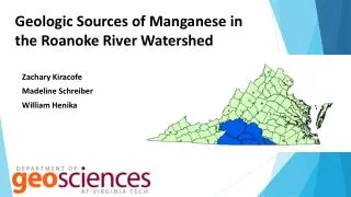
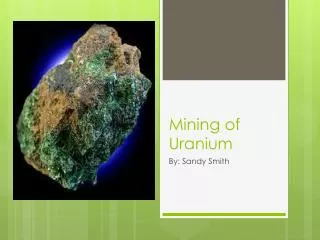
Evaluation of Potential Impacts of Uranium Mining on Drinking Water Sources in the Roanoke River Basin Assessment Approach . Presentation to Roanoke River Basin Bi-State Commission March 31, 2010. Background. Uranium in Virginia Leases were issued for uranium mining in the past

E N D
Evaluation of Potential Impacts of Uranium Mining on Drinking Water Sources in the Roanoke River BasinAssessment Approach Presentation to Roanoke River Basin Bi-State Commission March 31, 2010
Background • Uranium in Virginia • Leases were issued for uranium mining in the past • Coles Hill site in Pittsylvania County may have a large reserve • Uranium reserves are located upstream of drinking water supplies • Communities are concerned that uranium mining may impact their drinking water sources
Why the concern? Climate and landscape features in Virginia produce much greater precipitation than western US.
Project Description Coles Hill
Probable Maximum Precipitation Events in Virginia • Nelson County – August 1969 • 27 – 31 inches in 8-hours • Madison County – June 1995 • 30 inches in 14 hours
Extreme Flooding and PMP Events Average stream flow in VA – 1 cfs per square mi USGS Extreme Floods – 50 to 300 cfs per square mi
Project Description • Phase I Assessment: • Assume a PMP-type catastrophe and sediment release • Estimate of contaminated sediment to reach Kerr Reservoir • Assess potential increase in background radiation levels in Kerr Reservoir • Phase II Assessment: • Detailed analysis based on Phase I results (if deemed necessary).
Project Description • Phase I Assessment: • Banister and Roanoke Rivers will be modeled • One-dimensional numerical model will be used • CCHE1D: National Center for Computational Hydroscience and Engineering (NCCHE) at the University of Mississippi • CCHE1D simulates unsteady flows and sediment transport in dendritic channel networks • CCHE1D also simulates transport and fate of radionuclide's
Project Description • Phase I Assessment: • A number of containment failure scenarios will be run to represent: • Release quantities - small and large • Release durations – short and long • HEC-RAS model will also be run to address model uncertainty in sediment transport • Model will assume certain amounts of sediment release from hypothetical catastrophe • Phase 1 to be complete in Fall 2010
One Dimensional Modeling Objectives • Following a hypothetical PMP-event which releases certain quantities of mill tailings and effluents into the Banister or Roanoke Rivers: What amount of radionuclide-contaminated sediment and water might reach Kerr Reservoir? • In the short term (i.e. during the high-flow caused by the extreme precipitation event that triggered the failure) and • In the long term (during subsequent high-flow events of lesser magnitude, but higher frequency) What would be the potential increase in background radiation levels and other contaminants levels in Kerr Reservoir?
SENSITIVITY ANALYSIS • Modeling parameters: • Manning’s roughness, • adaptation coefficient, • sediment transport capacity formula, etc. • Meteorological Parameters: • Two different extreme events (500-yr & 100-yr storm events will be considered for short-term impact simulations) • Small and largereleased tailings • Short and longduration releases • This sensitivity analysis will provide information about the relative impact of each variable on the results.
UNCERTAINTY ANALYSIS • Three variables will be considered: • Volume of the sediment released • Initial radioactivity level of the tailings and the effluents • The distribution coefficient, Kd.
Independent Expert Review Panel • Specialized in key disciplines: • Uranium Milling/Disposal of Milling Waste/Geotechnical • Surface/Sub-Surface Water Contamination • Sediment Transport, Unsteady Hydrodynamic Modeling • Hydrology • Water Chemistry/Treatment • Assist in development of the approach for the Phase 1 • Review adequacy of data collected, critique the assumptions and the Phase 1 assessment design • Review, Critique and Evaluate Phase 1 report and conclusions