Download
1 / 13
130 likes | 288 Views
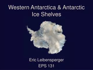
ITALIAN ANTARCTIC NATIONAL RESEARCH PROGRAM P.N.R.A. PERMAFROST AND CLIMATE CHANGE IN ANTARCTICA P.I. Prof. Mauro Guglielmin Insubria University - Varese, Italy. Permafrost and active layer Monitoring

E N D
ITALIAN ANTARCTIC NATIONAL RESEARCH PROGRAM P.N.R.A. PERMAFROST AND CLIMATE CHANGE IN ANTARCTICA P.I. Prof. Mauro Guglielmin Insubria University - Varese, Italy
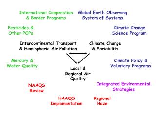
Permafrost and active layer Monitoring • Research Team: P.I. Prof. Mauro Guglielmin, Fabio Bajo, (DBSF, Insubria University, Varese), Francesco Dramis (DSG, Roma3 University) Andrea Strini (DSG,Milan University). • Project, installation, maintainance, management of all the permafrost and active layer stations and of the Calm Grid. Data archive and elaboration. • International agreement with B.A.S. (Cynan Ellis Evans, Roger Worland), Landcare Research ltd and Waikato University (Aislabie J., Balks M.), DNA-CADIC (National Direct. of the Ant. and Arg. Ant. Inst.,Centro Austral Inv. Cient. , Strelin). Signy Island Permafrost station and Calm Grid Oasi (Victoria Land) new borehole (30.3 m)
1 2 The drilling facilities include two equipment for: • 1) deep borehole (up to 30 m) • 2) shallow borehole (up to 7-8 m).
Permafrost and active layer monitoring stations Future IPY planned Permafrost and active layer monitoring stations Signy Jubany Anchorage Island Cape Ross Cape King In red the stations planned for the future. P.I. = 1 Guglielmin M.; 2 = Guglielmin M., Worland R (BAS); 3 = Guglielmin M., Balks M., Aislabie J. ; 4 = Guglielmin M., Strelin J. (DNA); 5 = Guglielmin M., Strelin J., Sone T. Mori J.; C: Continous monitoring; R: manual monitoring; * Calm Grid (100X100 m); ** Calm Grid (40x40m)
Permafrost study includes geophysical investigations (electrical surveys, ground probing radar) and coring of frozen sediments. Laboratory activities: chemical, isotopical, cristallographical, batteriological analyses of soil and ground ice. These tasks operating trough the cooperation also with other italian and foregneir researchers. Sampling Frost blisters Main goals of these activities are: Characterization of ground ice in different geomorphological features (rock glacier, debris covered glacier) Permafrost mapping Study of permafrost hydrology (ice blisters; talik) Analyses of permafrost ground ecosystem (yeasts, bacteria, fungi). Detection of subsea permafrost Tethys Bay (MZS): subsea permafrost found on the sea floor Megan Balks shows the longest permafrost core collected at Bull Pass
ICE WEDGES ANALYSES RESEARCH TEAM P.I. Prof.RaffiRossana,Sega Simone Department of Earth Science – “La Sapienza” University – Roma, Italy Stenni Barbara, Flora Onelio, Genoni Laura Department of Geological, Environmental and Marine Sciences - University of Trieste, Italy
MAIN RESEARCH GOALS • Definition: • of the ice-wedge thermal regime • of the processes occuring in the formation of • ice-wedges ice
INVESTIGATED AREA From Cape HallettPeninsulatoRicker Hills From Ross SeaCoasttoHelliwell Hills (Rennick Glacier)
EXCAVATED ICE-WEDGE POLYGON SITES • 45 IceWedges • 4 SandWedges • FIELD DATA COLLECTED • ActiveLayerDepth • Permafrost Table Depth • Ground Surface Temperature • Icewedge temperature profile • Air Temperature • Air Humidity • Incoming and reflectedsolarradiation • Soil color byMunsellSoil Color Chart • Icewedgestudyincludeslaboratoryactivities: cristallographical, isotopical, chemicalanalysesofice-wedgeice.
3 ICE-WEDGE THERMAL MONITORING STATIONS • Data loggers installed at three ice-wedge polygon sites along a longitudinal transect: • # 2 Testor 171-4 with 4 NTC (acc. +/- 0.2°C); • # 1 Campbell CR1000-XT with 4 PT100 (acc. +/- 0.1°C). • In each site the following temperatures are recorded in continuous since January 2004 : • - Air • Ground surface (-2 cm) • Ice-wedge top • Ice-wedge bottom “Rossana” Boomerang Glacier 74° 30’ 13’’ S 163° 50’ 10’’ E 874 m a. s. l. “Eleonora” Mount Jackman 72° 23’ 07’’ S 163° 10’ 49’’ E 1269 m a. s. l. “Viki” Baker Rocks 74° 12’ 27’’ S 164° 50’ 01’’ E 11 m a. s. l.
Terrestrial Ecology • Research Team: P.I. Nicoletta Cannone (Ferrara University), • Renato Gerdol (Ferrara University); Chiara Siffi (Ferrara University); Rosanna Piervittori (Turin University), Sergio Favero Longo (Turin University) • Main research goals: • - Selection of the most representative vegetation communities and sites to set up a network of permanent plots for the long term monitoring along two latitudinal transects at: 1) Victoria Land (Continental Antarctica) and 2) Tierra del Fuego-Antarctic Peninsula • Assessment of climate change impacts on terrestrial ecosystems through the monitoring of permanent plots and the detection of vegetation changes; • CO2 fluxes monitoring, soil changes within the monitoring network sites and plots • International Cooperations: • British Antarctic Survey; • Latitudinal Gradient Project; • SCAR- EBA (Evolution and Biodiversity in Antarctica)
Victoria Land Monitoring Network • - Survey of 26 study sites across 5 degrees of latitude (72°S – 77°S) along two main transects (1-coastal transect, 2-slope inland transect) • - Selection of 13 sites, installation and description of 19 permanent plots for the long term monitoring • Assessment of the influence of the latitudinal gradient on biodiversity patterns along the two transects; • Description of soil characteristics of the permanent plots • Monitoring of the ground surface temperature under different vegetation types CH Cape Hallett, RR Redcastle Ridge, CC Crater Cirque, CK Cape King, AI Apostrophe Island, CP Cape Phillips, EP Edmonson Point, CW Cape Washington, GO Gondwana, MK Mount Keinath, BC Boulderclay, II Inexpressible Island, CS Cape Sastrugi, SC Simpson Crags, TF Tarn Flat, LI Lamplugh Island, PI Prior Island, SN Starr Nunatak, CR Cape Ross, GI Gregory Island, KP Kar Plateau, FP Finger Point, DI Dunlop Island, MP Marble Point, FL Fryxell Lake