Download
1 / 23
230 likes | 332 Views
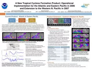
Advanced Applications of the Monte Carlo Wind Probability Model: A Year 2 Joint Hurricane Testbed Project Update. Mark DeMaria 1 , Robert DeMaria 2 , Andrea Schumacher 2 , Daniel Brown 3 , Michael Brennan 3 , Richard Knabb 4 , Pablo Santos 5 ,

E N D
Advanced Applications of the Monte Carlo Wind Probability Model: A Year 2 Joint Hurricane Testbed Project Update Mark DeMaria1, Robert DeMaria2, Andrea Schumacher2, Daniel Brown3, Michael Brennan3, Richard Knabb4, Pablo Santos5, David Sharp6, John Knaff1 and Stan Kidder2 1NOAA/NESDIS, Fort Collins, CO 2CIRA, Colorado State University, Fort Collins, CO 3NCEP National Hurricane Center, Miami, FL 4The Weather Channel, Atlanta, GA 5NOAA/National Weather Service, Miami, FL 6NOAA/National Weather Service, Melbourne, FL Interdepartmental Hurricane Conference March 2011
Outline • Brief overview of the MC model • Model computational improvements • Hurricane Landfall Probability Applications • Input for WFO products • HuLPA program for NHC
Monte Carlo Wind Probability Model • Estimates probability of 34, 50 and 64 kt wind to 5 days • 1000 track realizations from random sampling of NHC/CPHC or JTWC track error distributions • Intensity of realizations from random sampling of NHC/CPHC or JTWC intensity error distributions • Special treatment near land • Wind radii of realizations from radii CLIPER model and its radii error distributions • Serial correlation of errors included • Probability at a point from counting number of realizations passing within the wind radii of interest • Replaced NHC strike probability program in 2006
MC Probability Example Hurricane Bill 20 Aug 2009 00 UTC 1000 Track Realizations 34 kt 0-120 h Cumulative Probabilities
Forecast Dependent Track Errors • Use GPCE input as a measure of track uncertainty • GPCE = Goerss Predicted Consensus Error • Divide NHC/JTWC track errors into three groups based on GPCE values • Low, Medium and High • Reduces or increases probabilities ~10% • Evaluation in 2009 showed improved skill in all basins • GPCE version implemented in 2010
Current JHT Project Tasks • Model Improvements • Adjust time step for small/fast storms • Improve azimuthal interpolation of wind radii • Improve spatial interpolation for text/grid product consistency • Evaluate wind radii model • Advanced Applications • Application to WFO local products • Landfall timing and intensity distributions • Probabilities integrated over coastal segments • Automated guidance for watch/warnings
M1. Time Step AdjustmentCompleted and Implemented in 2010 Example:Hurricane Gordon, 19 Sept 2006 18 UTC R64 ~ 25 nmi, c = 28 kt ∆t = 2 hr ∆t = 1 hr
M2. Improve Azimuthal Interpolation • Special conditions • Slow moving, large storm • Max winds near 50 or 65 kt • Initial wind radii = 0 in some quadrants • Azimuthal interpolation of wind threshold radii can be smaller than next lower threshold 0-120 hr Cumulative Probabilities for TS Fay 18 UTC 20 Aug 2008
M2. Improve Azimuthal Interpolation t=0 hr probabilities for TS Fay 18 UTC 20 Aug 2008 34 kt 50 kt 50 kt (corrected) • Solution: Impose radius of max wind as lower bound on outer wind radii interpolation • Ready for implementation in 2011
M3. Improve spatial interpolation • Graphical Products • Probabilities generated on 0.5 deglat/lon grid • Interpolated to 5 km grid for NDFD • Text Product • Probabilities calculated at specified coastal points • NDFD and text values sometimes disagree • Test higher resolution gridded product • Hurricane Charley (2004) and Ike (2008) test cases
M3. Improve spatial interpolation:Convergence Tests Comparison of direct and interpolated probabilities at coastal points
0.5 deg grid Max Error = 20.1% @ Marquesas Key, FL Min Error = -24.1% @ N Marquesas Key, FL Reduced to ~10% with 0.25 deg grid Recommend running at 0.25 deg grid in 2011
M4. Evaluation of Wind Radii Model MC model (t=72 hr) and observed distributions of 34 kt wind radii Conclusion: MC radii adequate Few alternatives given limited input (track, max wind)
A1. WFO Local Products Extensive verification (2003-2010) completed for P. Santos and D. Sharp to guide probability threshold selection
A2-A4. Landfall Applications • User interface written for product testing • Hurricane Landfall Probability Applications (HuLPA) • Java program as ATCF prototype • Applications • Landfall timing/intensity distributions • Time of arrival/departure distributions of 34, 50 and 64 kt winds • Integrated coastal probabilities • Automated guidance for watches/warnings • Plots of all 1000 realizations
HuLPA: Plotting 1000 Realizations Full Tracks Single Time (72 hr) Hurricane Earl 06 UTC 01 Sept 2010
Hurricane Earl 9/1 11pm EDT No GPCE NHC GPCE Impact of GPCE Input on Automated Watch/Warnings
Hurricane Earl 9/2 11pm EDT No GPCE NHC GPCE Impact of GPCE Input on Automated Watch/Warnings
Model and Application Documentation • Operational Tropical Cyclone Wind Speed Probabilities. Part I: Recent Model Improvements and Verification • Operational Tropical Cyclone Wind Speed Probabilities. Part II: Advanced Applications • M. DeMaria, J. Knaff, M. Brennan, D. Brown, C. Lauer, R. DeMaria, A. Schumacher, R. Knabb, D. Roberts, C. Sampson, P. Santos, D. Sharp, K. Winters • To be submitted to Weather and Forecasting, March 2011
Future Plans • Possible 2011 Modifications • New radii interpolation • Prevents inconsistent 34, 50, 64 kt probabilities • Increase grid resolution from 0.5o to 0.25o • Reduces inconsistency between gridded and text products • Requires modification of NHC driver programs • Test HuLPA in real time in 2011