Download
1 / 60
620 likes | 795 Views
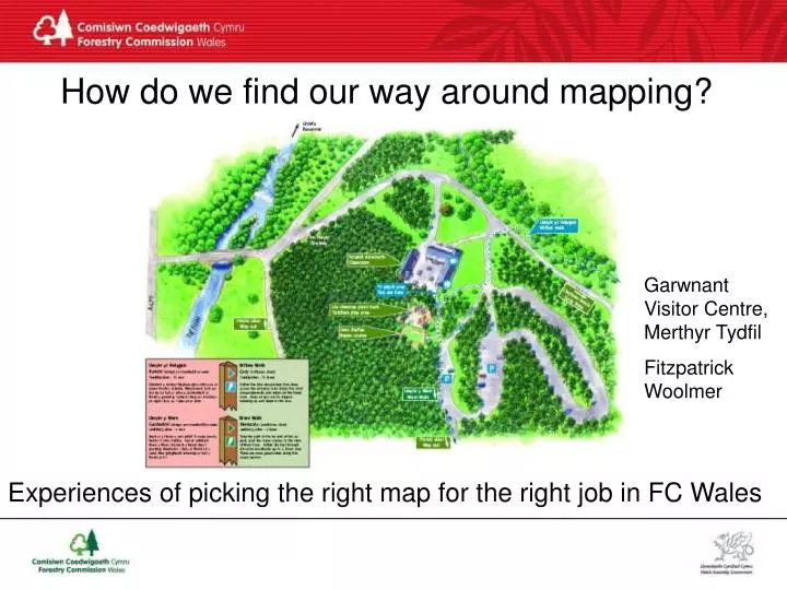
How do we find our way around mapping?. Garwnant Visitor Centre, Merthyr Tydfil Fitzpatrick Woolmer. Experiences of picking the right map for the right job in FC Wales. Who did that map?. Courtesy of Pembrokeshire Coast National Park. Community interpretive map. Brechfa Creu-ad.

E N D
How do we find our way around mapping? Garwnant Visitor Centre, Merthyr Tydfil Fitzpatrick Woolmer Experiences of picking the right map for the right job in FC Wales
Who did that map? Courtesy of Pembrokeshire Coast National Park
Community interpretive map Brechfa Creu-ad
Communityinterpretive placenames map Coed y Brenin Creu-ad
Communityinterpretive placenames map-detail Coed y Brenin Creu-ad
Communityinterpretive placenames map-detail Coed y Brenin Creu-ad
Close-up of inset location map Coed Maenarthur, Ystwyth Valley, Ceredigion, Argraff
The starting point: 1:25000 OS map Ty’n y Groes, Coed y Brenin Ordnance Survey
Mountain BikeOS based map in FCW walks map style Carron Valley Trail, FC Scotland
Mountain BikeOS based contour heavy map Glentress, FC Scotland
Mountain BikeOS based even more simplified map Wolftrax trails, FC Scotland
Mountain BikeOS based simplified map Learnie Red Rock trails, FC Scotland
Mountain Bike drawn map Fire Tower Trails, FC Scotland
Mountain Bike OS based map Current FC Wales standard MB map The Beast, Coed y Brenin Argraff
Mountain Bike map with route profile Gorlech Trail, Brechfa Forest Argraff/dlc
Back to the starting point: 1:25000 OS map Ty’n y Groes, Coed y Brenin Ordnance Survey
Flat OS based map Mynydd Penrhos Mountain Trail, Ty’n y Groes, Coed y Brenin Argraff
Actual painting before graphic designer’s ‘layer’ Ty’n y Groes, Coed y Brenin Argraff
Painted local map based on aerial photography and OS mapping Llyn Geirionydd, Gwydyr Forest Park Atkins-Heneghan
Painted straight-down view based on aerial photo Mynydd Penrhos Mountain Trail, Ty’n y Groes, Coed y Brenin Argraff
Example area/local panel Lower Wye Valley Argraff
Painted area map based on aerial photography and OS mapping Lower Wye Valley Argraff
Horse riding trailsaerial photography map Dyfnant Soft Trails, Dyfnant Forest Argraff
Horse riding trailsaerial photography map Dyfnant Soft Trails, Dyfnant Forest Argraff
Aerial photo based Newborough, Anglesey Argraff
Aerialphoto Dolgellau
Computer generated OS based map Waterfalls area, Brecon Beacons National Park Jon Dixon
Flat OS based map with relief shading Abergynolwyn, Dyfi Forest Lorna Jenner
Painted area map showing relief Lorna Jenner
Painted area map showing relief Forest of Dean, FC England
Computer generated/painted landscape map Simon Holt Simon Holt
Painted oblique view with inset walk map Talley/Talyllychau, Carmarthenshire/Sir Gar Argraff
inset walk map Talley/Talyllychau, Carmarthenshire/Sir Gar Argraff
Painted based on aerial photos and OS maps Afan Forest Park Gary Short
panoramic painted map Kerry Ridgeway, Ceri near Newtown Simon Holt
Panorama style with walking routes Geirionydd, Gwydyr Forest, unknown
panoramic painted map Bwlch Nant yr Arian Argraff
panoramic painted map - same artist different style Bwlch Nant yr Arian Argraff
‘Skiing’ map style Neath Port Talbot/Ridler Webster
3D Relief style Queen Elizabeth Forest Park FC Scotland
panoramic painted map - world’s best artist Yellowstone National Park, Berann
panoramic painted map - world’s best artist Everest, Berann
Tactile map Caerphilly CBC Dave Penberthy
Tactile mapdetail Caerphilly CBC Dave Penberthy
Tactile reliefmap:mountains Glen Coe, unknown
Tactile mapsandblastedwood Craig-y-nos Country Park, Brecon Beacons National Park
‘Vector’ or computer generated visitor centre map Afan Forest Park Gary Short
Close-up of Vector map Afan Forest Park Courtesy Gary Short