Download
1 / 19
190 likes | 439 Views
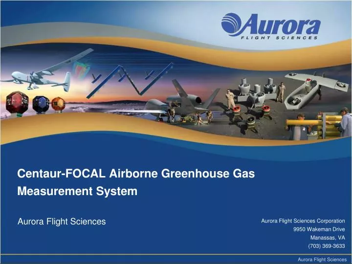
Centaur-FOCAL Airborne Greenhouse Gas Measurement System. Aurora Flight Sciences. Aurora Flight Sciences Corporation 9950 Wakeman Drive Manassas, VA (703) 369-3633. Unmanned Flight Innovation. 22 years of innovation in robotic aircraft

E N D
Centaur-FOCAL Airborne Greenhouse Gas Measurement System Aurora Flight Sciences Aurora Flight Sciences Corporation 9950 Wakeman Drive Manassas, VA (703) 369-3633
Unmanned Flight Innovation 22 years of innovation in robotic aircraft Demonstrated experience, mature processes, and flight validated technology Direct experience in high performance UAS development including advanced payload and communications system integration
Arctic Regional Carbon Flux Measurements Areas of high methane emissions in the Arctic include Alaska, Western-Canada, and Siberia. These emissions will likely increase as the Arctic ice cap continues to retreat each summer and Arctic region continues to warm
Arctic Permafrost Changes • Permafrost • Soil that remains frozen for more than 2 years • Contains biomass that has not decomposed • Much is older than last ice age • Recent changes • Expansion of thermokarst lakes due to elevated surface temperatures, rapid Arctic warming • Melted biomass anoxic decomposition producing methane • Changes largely unexpected and not widely modeled • Risks • Methane >20 times more powerful GHG than CO2 • 1400-1850 GtC sequestered in soils • IF 0.5% of permafrost melts annually, CO2 equivalent will be equal to all other man made GHG sources (not happening yet) • Risk of irreversible tipping point if triggered • Significant uncertainty – timing, processes, and impact
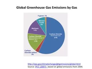
Other GHG Flux Measurements • Biogenic (natural) • Ocean methane hydrates • Ocean microbes – methane release from ice cracks • Wetlands, peat, and forests under stress • Fossil carbon release from retreating glaciers • Ocean carbon exchange • Anthropogenic (man-made) • Hydraulic fracturing sites – fugitive emissions • Well heads and storage tanks • Natural gas pipelines and aging infrastructure – leak detection • Refineries • Port facilities and transportation networks • Agriculture (ruminants and rice farming) • Waste treatment and landfills • Municipalities
The Climate Intelligence Cycle • Slow today (glacial pace) • 2-9+ year cycle not unusual • Changes in the Arctic can happen rapidly • i.e. 2007 and 2012 sea ice extent • Risk areas: permafrost, sea ice, glaciers • Sparse sustained regional observations • Limited early warning capability 1. Planning and Direction: Guidance documents: ~ 1-4 years Program formulation: ~ 1 year Proposal/award cycle: ~ 0.5-1 year 2. Collection: (Airborne) Instrument development, integration, deployment, collect: 0.5-2 yrs (New satellite) Development, launch, calibration, collection: 5-12 years (Legacy satellite) Collection: weeks/months 3. Processing: Data analysis: < 0.5 year Global climate model updates: 2-5 years 4. Analysis and Production: Peer reviewed journals: ~ 0.5-1 years 5. Dissemination: US and UN assessment reports: 4-9 years
The Mission PlatformAurora’s Centaur Optionally Piloted Aircraft (OPA) • DA-42MPP Converted to OPA • Manned/Unmanned, Hybrid – Airspace Flexibility • Self-deployable operations • Minimal footprint • 4 hour conversion to OPA • MALE UAS (Predator A class) • World-wide sustainment • 135-160 KTAS cruise; 80 KTAS loiter • 800lb payload capacity • 200 lbs X 24 hrs for unmanned • Flexible payload locations • Efficient operation – 7 gal/hr heavy fuel • Mobile STANAG 4586 GCS • Fully autonomous operation, including ATOL, waypoint navigation & mission action commands
Centaur-FOCAL for GHG Monitoring • Optionally piloted capability • Airspace flexibility • Precision, automated collection patterns • Very low altitude flight • High GHG spatial resolution • Affordable regional and local coverage • Low fuel consumption, heavy fuel engines • Low aircraft cost – acquisition and maintenance • Real time isotopologue fluxes • Unprecedented specificity of CO2 and CH4 isotologues • Discriminates natural and anthropogenic sources • Measures vertical wind speed • Unique ability to quantify fluxes and link to sources • Point and dispersed sources
Our Team • Co-Principle investigators • Developed sensor payload • Provide data analysis • Co-Principle investigators • Developed BAT Probe • Provide data analysis CENTAUR • Aircraft provider • Payload integrator • Flight operations
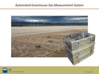
Flux Measurements • High precision and accuracy measurements of vertical wind relative to Earth • High precision and accuracy measurements of carbon isotopologues • Integrated Cavity Output Spectroscopy (ICOS) – continuous wave tunable laser • QCL and cavity enhancement • Aircraft capable of flying at slow speeds, close to the ground, and having power/weight/volume capable of supporting scientific payload
The Best Air Turbulence (BAT) ProbeMeasures Vertical Wind Speed to 2 cm/s • The BAT probe consists of a 155 mm hemisphere with ports arranged to measure the pressure distribution over its surface. • Pressure differences yield angle of attack and angle of sideslip which are converted to wind speed relative to the probe and aircraft. • A GPS/INS system measures speed of aircraft relative to the ground. • Calibrations in a wind-tunnel and in flight yield vertical wind speed to a precision and accuracy of 2 cm/s. The BAT probe mounted on Aurora's Centaur aircraft
The FOCAL Payload(Flux Observations of Carbon from Airborne Laboratory) • Detection system to measure the fluxes of methane, nitrous oxide, and water vapor. CH4, N2O, H2O, HDO • Detection system to measure the fluxes and isofluxes of carbon dioxide and its isotopologues. CO2, 13CO2, CO18O • Detection system to measure the isofluxes of methane. CH4, 13CH4
Arctic Regional Carbon Flux Measurements Aerial photo of the a small section of Alaska's North Slope showing the heterogenous landscape of thermokarst lakes, drain basins, rivers, and permafrost.
Operations Aerial view of the North Slope region. The black spots are lakes. Due to the heterogeneity of the geography and geomorphology, quantifying the region's methane emissions requires measuring coastal waters of the Arctic ocean, lakes, rivers, and interstitial permafrost across the entire region.
Other Systems - Highlights • Ground monitoring stations • >300 GHG ground monitoring stations • Permafrost bore hole temperature sites • Ships: NOAA, US Navy • Satellites • NASA Aqua • JAXA GOSAT • Future: NASA OCO2, ASCENDS • Airborne systems • NOAA/ESRL CCGG group – flask measurements • HIPPO • In-service Aircraft for a Global Observing System (IAGOS) • Japanese airliner samplers • Myriad limited research efforts • Processing Exploitation and Dissemination (PED) • NOAA National Climate Data Center
Advantages of UAS • Long duration in/over target • Longer dwell than LEO satellites • Less transient than balloons • Longer duration than manned aircraft • Dangerous operations – flight through volcanic ash, thunderstorms, hurricanes • High altitude • Lower cost for high altitude ops • Very low altitude flight • Repetition – “dull” missions • Autonomous parcel tracking • High accuracy – 3D position • Short slant range • In situ measurements • Responsive– not bound by Kepler, respond to measurements • Payload flexibility – change between missions • Emplacement of other systems – UUV, USV, UAS, buoys, UGS, dropsondes • Extends measurement range of field sites and ships