Download
1 / 1
10 likes | 150 Views
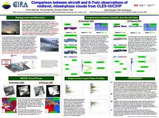
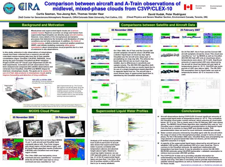
CloudSat. 1825 UTC on 05 Nov 2006 Aqua MODIS: Cloud top temperature CloudSat CPR cloud classification. Supercooled liquid layer from CALIPSO. Convair-580. Comparison between aircraft and A-Train observations of midlevel, mixed-phase clouds from C3VP/CLEX-10.

E N D
CloudSat 1825 UTC on 05 Nov 2006 Aqua MODIS: Cloud top temperature CloudSat CPR cloud classification Supercooled liquid layer from CALIPSO Convair-580 Comparison between aircraft and A-Train observations of midlevel, mixed-phase clouds from C3VP/CLEX-10 Curtis Seaman, Yoo-Jeong Noh, Thomas Vonder Haar (DoD Center for Geosciences/Atmospheric Research, CIRA/Colorado State University, Fort Collins, CO) David Hudak, Peter Rodriguez (Cloud Physics and Severe Weather Section, Environment Canada, Toronto, ON) Comparisons between Satellite and Aircraft Data Background and Motivation 05 November 2006 25 February 2007 Mixed-phase and supercooled liquid clouds are a serious aviation hazard. Rapid ice accretion on wings and frames from supercooled liquid droplets can directly cause aircraft crashes. However, many details of the microphysical and dynamic processes that determine the formation and dissipation of icing conditions are not fully understood. In addition, the fields ofremote sensing, radiative transfer, numerical weather prediction (NWP), and climate modeling commonly utilize gross assumptions about mixed-phase cloud properties due to a lack of extensive in situ observations. CloudSat Aircraft Ka CALIPSO CloudSat Aircraft Ka CALIPSO LWC & cloud mask LWC & cloud mask On 5 Nov 2006, the A-Train and the Convair-580 aircraft sampled a broad Ac cloud. CALIPSO saw a distinct liquid layer at cloud top (top right). CloudSat saw the aircraft and a deep layer of precipitating ice virga (top left). The airborne Ka-band radar did not see as much virga (top middle), due to differences in sensitivity and sample volume. The 2B-CWC-RO algorithm (left) mis-identified the ice virga as mostly liquid due to its use of a simple temperature-based algorithm to separate liquid from ice. The aircraft saw a much thinner layer of supercooled liquid than is identified by the CloudSat retrieval (below). On 25 Feb 2007, the A-Train and the Convair-580 aircraft sampled a broad As cloud. This cloud was classified as “ice” by MODIS as well as CloudSat. 2B-CWC-RO had LWC only at cloud base where temperatures were above -20 oC (left). Significant amounts of supercooled LWC were observed by the aircraft at cloud top (below left and right) at temperatures down to -32 oC. CALIPSO saw some parcels of LWC also (above right). The 2B-CWC-RO assumption that no liquid water can exist at temperatures below -20 oC is incorrect in this case. In this study, extensive in situ observations of mixed-phase clouds have been collected from a research aircraft with coincident remote sensing data from the A-Train satellite constellation (Aqua, CloudSat, CALIPSO, PARASOL, Aura) during the joint Canadian CloudSat/CALIPSO Validation Project (C3VP) and 10th Cloud Layer EXperiment (CLEX-10) field experiments. Coincident aircraft observations have been analyzed and compared with satellite observations and retrievals from CloudSat, CALIPSO and MODIS (Aqua) for mid-level, mixed-phase clouds. The goals are to assess the use of A-Train data products in mixed-phase clouds and to improve forecasting and detection of icing conditions. IWC & cloud mask IWC & cloud mask altitude (left) Experimental set-up. The Convair-580 research aircraft was flown along the CloudSat ground track while the A-Train satellites passed overhead, providing coincident observations of mixed-phase cloud conditions from in situ and remote sensing instrument platforms. altitude LWC LWC icing icing temperature This research was supported by the Department of Defense Center for Geosciences/Atmopheric Research at Colorado State University under Cooperative Agreement W911NF-06-2-0015 with the Army Research Laboratory. temperature MODIS Cloud Phase Supercooled Liquid Water Profiles Conclusions • Aircraft observations during C3VP/CLEX-10 reveal significant amounts of supercooled liquid water at temperatures down to -32 oC. This contradicts the CloudSat cloud water content retrieval, which assumes all cloud water below -20 oC is ice. This is clearly seen in the 25 February 2007 case shown above. The MODIS Cloud Phase algorithm also classified this case as “ice”. CloudSat uses a simple temperature parameterization to distinguish liquid from ice that is common to many NWP and climate models. This parameterization does not work for most mid-level, mixed-phase clouds. • Water content amounts retrieved by CloudSat agree with the aircraft within the range of values of the microphysical probes, except in terms of cloud phase. For the 5 November 2006 case, CloudSat likely sees precipitating ice virga (based on ground based lidar data not shown), yet the retrieval algorithm assumes it is liquid. • A majority of the supercooled liquid layers observed by aircraft have an adiabatic LWC profile, with maximum LWC at or near cloud top. This is contrary to the CloudSat retrievals. No significant relationship with temperature has been found. It may be possible to correct the 2B-CWC-RO/RVOD retrievals using CALIPSO backscatter + adiabatic assumption to retrieve more accurate LWC/IWC profiles. • The C3VP/CLEX-10 data set is providing valuable information for understanding and improving forecasts and retrievals of mixed-phase clouds and icing. This data is now being used to provide improvements to satellite retrieval algorithms as well as numerical model parameterizations for these clouds. 05 November 2006 25 February 2007 For the two cases here we have Aqua MODIS 12 mm Tb with aircraft and CloudSat track overlayed (above left), True Color images with target region circled (above right), and IR Cloud Phase algorithm results (Collection-5 MYD06) with CloudSat track and target region circled. The 5 Nov 2006 case had patchy cirrus overhead and was classified as “uncertain”, while the 25 Feb 2007 case had no cirrus overhead and was classified as “ice”. Analysis of 55 vertical cloud profiles from CLEX-9 and CLEX-10 aircraft data shows that supercooled liquid water is poorly correlated with temperature (above) and absolute height (above right). Relative to cloud top (right), however, we see LWC typically peaks at or near cloud top. 41 of the 55 supercooled liquid layers are less than 1 km thick. 29 of the 55 profiles exhibit a LWC profile that is (or is nearly) adiabatic. Seaman@cira.colostate.edu and Noh@cira.colostate.edu