Download
1 / 39
390 likes | 498 Views
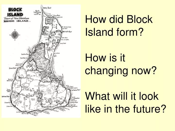
How did Block Island form? How is it changing now? What will it look like in the future?. Block Island: a product of Erosion and Deposition. weathering: the change/breakdown of rock on Earth’s surface erosion : movement or transportation of weathered materials

E N D
How did Block Island form?How is it changing now?What will it look like in the future?
Block Island:a product of Erosion and Deposition • weathering: the change/breakdown of rock on Earth’s surface • erosion: movement or transportation of weathered materials • agents of erosion: gravity, wind, glaciers, and water (ocean currents and waves, streams, groundwater) • deposition: the leaving behind of materials carried by erosion • agents of deposition: gravity, wind, glaciers and water (same as for erosion)
Wind Erosion • Wind: erodes land by carrying away rock particles • mostly smaller particles: sand and rock dust (silt and clay) are carried by wind
Wind Deposition • deposition by wind: most common – dunes (mounds of wind-blown sand) • gentler slope of a dune – faces wind
Slumping: erosion from groundwater and gravity Large block falls off a cliff or bluff forms- sea cliffs/bluffs
Erosion by ocean waves • physical weathering: force of the water weathers and erodes the shoreline affecting beaches
Ocean Wave Deposition • beaches: deposits of sand or larger particles on ocean (or lake) front • beach changes seasonally – remember beach profile?? • berm: top of the sloping surface (above is part for recreation) • sand bar: long underwater ridge of sand carried away from beach
Wave anatomy • Wavelength: distance between 2 crests or 2 troughs • Waveheight (2 X amplitude): height from trough to crest • How could you determine these??
Wave characteristics • Waveperiod: the time is takes for a wave to pass a fixed point • Wavefrequency: the number of waves that pass by in a given time. • How could you determine these??
Wave characteristics 2 • Wave speed: the distance traveled by a given point on the wave (such as a crest) in a given interval of time. In equation form:
Longshore Currents • general movement of sand along beach: in same direction that waves hit shore • longshore current: movement of water and sediment parallel to, and near shoreline • animation: http://www.learnnc.org/lp/multimedia/14706 • Real video: http://www.youtube.com/watch?v=l70ioFTD6TY&safe=active&safety_mode=true
Features from longshore current deposition: • Headland: land surrounded by water on three sides • spit: long narrow deposit of sand connected at one end of shore • tombolos: ridge of sand deposits connecting islands to mainland
Glacial Erosion • Glaciers are “rivers of ice” slowly flowing, moving sediments and changing the surface and shape of the ground beneath it • Last glacial ice age in NE ended about 18,000 years ago
Glacial Deposits • glacial till: unsorted glacial materials • stratified drift: sorted and deposited in layers by meltwater Glacial erratic
Features from glacial deposition: • Glacial moraines: landforms made from glacial till • terminal (end) moraine: deposited at the end
More features from glacial deposition: • moraine • erratics: large boulders transported by glaciers
More Glacial Deposition features • drumlins: low tear-shaped mounds of till • kettles: depressions left from melting ice
Stratigraphy • Stratigraphy is the study of strata, or layers • Stratigraphy can tell us about how the soil was deposited, they are clues to the land’s origin
Your tasks in the field(gathering evidence for your big 3 questions)
Creating a Contour/Elevation Map • Use your elevation observations to determine the higher/lower points on BI • Draw contour lines onto the map
Task 2: Sieving soil, to tell particle size • You will collect soil samples to sift with “sieves” • These will separate the soil into different sized particles – gravel, fine gravel, coarse sand, fine sand and silt and clay • Sieving Purpose: this tells how the soil got there
Sand, different sizes deposit by different ways • How is sand classified? If you classify sand by size, you look at the diameter of each sand particle. Very coarse sand, like you might see in a sand box, has the largest particles. The diagram below shows the actual size of sand particles from 0.5 to 2 mm in diameter. • very fine 0.05 - 0.01mm • fine 0.1 - 0.25mm • medium 0.25 - 0.5 mm • coarse 0.5 - 1 mm • very coarse 1 - 2 mm
Conclusions from sieving and soil profiling: • The bigger the sand particle size, the steeper the beach typically is: • Steep, big particle beaches are formed from strong deposition forces and erosion • This makes them less stable • Flat, small particle beaches are formed from gentle deposition forces, and are more stable
Task 3: create a beach profile • Beach profiling provides clues as to: • how the beach formed • how is it changing now
How does the beach change over time? • The shape of the beach is in continual change due to the weather and tides. • In calmer weather with regular tides, sand is gradually deposited onto the beach from sand bars out in the ocean, dunes and berms may form. • In stormy weather, the beach erodes and sand is brought from the beach to sand bars, which run parallel to the shore (provides better surfing).
Task 4: Measuring wind speed and direction • Wind speed: use an anemometer • Wind direction: use the compass