Download
1 / 17
170 likes | 177 Views
Methodology for Delineating Cities and Rural Areas in Mexico UNHQ, New York, 28-30 January 2019 (Mexico) Edgar Vielma Orozco. Summary. 1oooooooooooooooooooooooooooooooooooooooooooooooooooooooooooooooooooooooooooooooooooooooooooooooooooooooooooooooooooooooooooooooooooooooo.

E N D
Methodology for Delineating Cities and Rural Areas in Mexico UNHQ, New York, 28-30 January 2019 (Mexico) Edgar Vielma Orozco
Summary 1oooooooooooooooooooooooooooooooooooooooooooooooooooooooooooooooooooooooooooooooooooooooooooooooooooooooooooooooooooooooooooooooooooooooo 1oooooooooooooooooooooooooooooooooooooooooooooooooooooooooooooooooooooooooooooooooooooooooooooooooooooooooooooooooooooooooooooooooooooooo 1oooooooooooooooooooooooooooooooooooooooooooooooooooooooooooooooooooooooooooooooooooooooooooooooooooooooooooooooooooooooooooooooooooooooo The National Institute of Statistical and Geographic Information (INEGI) and the National Geostatistical Framework (MGN) Considerationsonthe methodology proposed for Delineating Cities and Rural Areas in Mexico 2020 Final thoughts
The National Institute of Statistical and Geographic Information • The National Institute of Statistical and Geographic Information (INEGI) is in Mexico the autonomous public organization that generates information on demographic, social, economic and environmental phenomena and its relation with the national territory in order to contribute to the development of the country. • The National Geostatistical Framework (MGN, for its acronym in spanish) is a unique and national system designed by INEGI to correctly reference the statistical information of the censuses and surveys with the corresponding geographical places, provides the position of localities, municipalities and entities of the country, using geographical coordinates. • The MGN, besides guaranteeing geographic coverage and national monitoring of the Economic Censuses, Population and Housing Census, Agricultural Census and Surveys, is a tool for the stages of planning, surveying, treatment, presentation and dissemination of the information collected in field.
The National Geostatistical Framework (MGN) • The MGN divides the national territory into areas with identifiable limits in the field, called Geostatistical Areas, with three levels of disaggregation: State, Municipal and Basic, which may be urban or rural. The rural basic geoestatistical areas are divided into geoestatistical locations (with less than 2500 inhabits); one or more urban basic geoestatistical areas conform one urban geosetatistical locations. • Some levels of MGN disaggregation very after the Intercensal Survey 2015 correspond to the following: 32 StateGeostatisticalAreas 2 458 Municipal GeostatisticalAreas 4 562 UrbanGeostatisticalLocations 50 821 Rural GeostatisticalLocations 2 323 131 Geostatistical blocks
The methodology proposed applied to Mexico Applied procedure Create the reticle —square cells of 1 Km2. Trim the block of houses. Count the population for each cell according the blocks —total or partial— inside the grid cell. Separate those grid cells with a population greater than or equal to 1500 inhabitants (high density grid cells); cluster them and select those clusters with at least 50’000 inhabitants (urban centre). Separate those grid cells with a population greater than or equal to 300 inhabitants and less than 1500 inhabitants (moderate density grid cells); cluster them and select those clusters with at least 5’000 inhabitants (urban cluster). Separate those grid cells with a population below 300 inhabitants (low density grid cells) and other cells that do not belong to an urban centre or urban cluster. Classify resulting clusters and cells according to the degree of urbanization level 2
The methodology proposed applied to Mexico • The coverage of the grid cells of 1 km2 was generated for the entire national territory. • Fuente: INEGI, Censo de Población y Vivienda 2010.
The methodology proposed applied to Mexico • The cell coverage of 1 km2 was superposed on the MGN to characterize the cells based on density and population information. • The population assigned to each cell corresponds to the sum of the total or partial population contained.
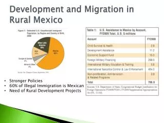
Findings of the application of the proposed methodology • Of the total of 1’960’333 grid cells covering the national territory, 269’166 correspond to inhabited areas in the country. • Up to 3 113 clusters were generated from the cells with a population density of 1 500 or more inhabitants / km2 (high density cells), which means 69.6% of the total population. The map shows the 7 groups of highest population strata in the central part of Mexico (Mexico City, Toluca, Cuernavaca and Puebla)
Evaluation of the applicability of the parameters for the delineation of urban and rural areas • The proposed definitions are very similar to the National Geostatistical Framework used at INEGI, but in any case they could be made comparable because INEGI has geo-referenced Census data with enough level of disaggregation: block of houses and localities. So the proposed methodology could be successfully adopted and adapted in Mexico. • The main technical obstacles to implementing the proposed methodology around the world could be the absence of geo-referenced data to place the data in the correct grid cell. Not having a sufficient level of disaggregation of the data for an accurate measurement in the cells of the grid.
Considerations to the methodology proposed in the Mexican case • The concept of contiguity should be defined in a homogeneous way for all the countries: • Two grid cells boundary, or • Two grid cells are contiguous if they share a boundary or one vertex. • It is because in several cases is useful to use both, depending on the purposes. Example: Zamora and Jacona are two localities conurbated, but the cells do not recognize their contiguity because they are touched in a vertex.
Considerations to the methodology proposed in the Mexican case In Mexico, efforts have been made to resolve the urban-rural dichotomy through the methodology for the Delimitation of Metropolitan Areas. • The criteria to define the category of central municipality of the metropolitan areas are: • Intermunicipal conurbation of 100 thousand or more inhabitants. • Cities with: • 100 thousand or more inhabitants with a high degree of physical and functional integration with neighboring municipalities; • 500 thousand or more inhabitants or state capitals; • 200 thousand or more inhabitants, not more than 20 kilometers from the border zones or located on the coasts:
Considerations to the methodology proposed in the Mexican case • The criteria to define the category of external municipality of the metropolitan areas are: • Geographical. Distance of 15 kilometers to the central city. • Functional integration. Percentage of employed population from 15 to 70 years of age that travels daily (15% or more of the Economically Active Population occupied resident works in the central municipalities of the ZM or 10% or more of the Economically Active Population that works in the municipality resides in the central municipalities). • Urban character. Employed population from 15 to 70 years in non-primary activities (75% or more). Average urban density (20 or more inhabitants per hectare). • Urban policy.
Considerations to the methodology proposed in the Mexican case Results 74 metropolitan areas were identified. 13 metropolitan areas exceeded one million inhabitants. This group concentrates 46.6 million, which is equivalent to 62% of the metropolitan total. 23 metropolitan areas have between 500 thousand and less than one million inhabitants, with 17.9 million people, 23.8% of the metropolitan total. 38 metropolitan areas have less than 500 thousand inhabitants, with a population of 10.6 million, that is, 14% of the metropolitan total. The Valley of Mexico is still the metropolitan area with the largest number of demarcations and municipalities, with 76.
Considerations to the methodology proposed in the Mexican case • We believe that the population and population density data are insufficient to delineate cities and rural areas, because there are some low density areas that look like urban areas, since they have sufficient public services and infrastructure. • Accordingly, complementary information should be used, such as density of economic establishments and occupied personnel, as well as public services, infrastructure and urban furniture, among others.
Convenience of presenting the proposed methodology to the United Nations Statistical Commission The proposed methodology has a set of virtues that translates into an excellent opportunity to have a global delimitation of the different types of settlements based on a basic but concrete typology, which is elaborated based on clear, homogeneous and systematic criteria, in order to generate, disseminate and compare different types of statistics between countries and regions. The experience of its use in the European Commission confirms the correctness of this delimitation, for this reason we highly recommend that the methodology be presented to the Statistical Commission of the United Nations, which will undoubtedly be of great benefit to improve the measurements and the production of indicators, of the member countries.
Final thoughts Four final thoughts In the same sense of comparability, consider transforming the metric-based reticle into a degree-based reticle —30” or 15”— in order to avoid problems with cartographic projections and origin coordinates, as well as gaps and overlapping areas. We suggest to use a worldwide coverage, where each grid cell has a unique id. Consider to include density of economic establishments, of occupied personnel and dwellings, as well as existence of services inside the dwellings and infrastructure, in the local unit. Provide technical assistance to countries that may have difficulties in adopting this methodology. Thank you very much