Download
1 / 19
190 likes | 409 Views
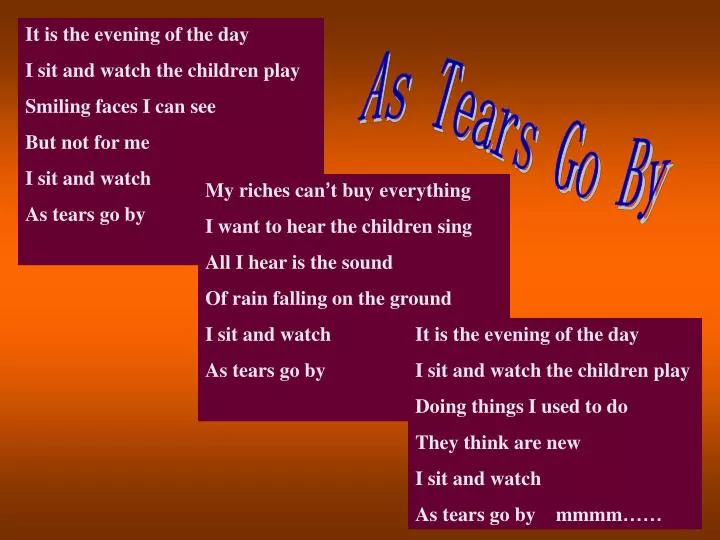
It is the evening of the day I sit and watch the children play Smiling faces I can see But not for me I sit and watch As tears go by. As Tears Go By. My riches can ’ t buy everything I want to hear the children sing All I hear is the sound Of rain falling on the ground I sit and watch

E N D
It is the evening of the day I sit and watch the children play Smiling faces I can see But not for me I sit and watch As tears go by As Tears Go By My riches can’t buy everything I want to hear the children sing All I hear is the sound Of rain falling on the ground I sit and watch As tears go by It is the evening of the day I sit and watch the children play Doing things I used to do They think are new I sit and watch As tears go by mmmm……
IQ Test is to as is to … C D A B —
For the picture sequence(一连串) on the left, find the picture that follows logically(逻辑上) from one of the six below. A B C D E F
A map of the world China New Zealand
Talk about the map Name Location Area Population Capital Language Minority Resource
Background to China: Full country name______________________________ Location _________________________________ Area___________________________ Population _______________________________ Capital city__________________ Languages___________________ Religions_________________ Minorities _______________________ Major products/industries_____________________________ The People’s Republic of China East Asia 9,600,000 square kilometers 1,300,000,000 (approximately) Peking/Beijing Mandarin / Putonghua Buddhism(佛教) 56 Silk , iron, oil, coal, clothing, etc.
Competition in asking and answering Where is …? What’s the position of …? Where is … located? ▲ ▲ ▲ ▲ ▲ ▲ vvvv ▲ ▲ ▲
Guessing game Instruction A: A student will come to the front and guess the names of places his or her classmates will describe. The Yellow River India Moscow Iraq Hong Kong Hainan Island Taiwan Strait The Pacific Ocean Pakistan Japan Mongolia Shanghai North Korea People’s Republic of China South Korea The Chang Jiang River
Guessing game Instruction B: A student will come to the front and guess the names of places by asking different questions. The USA Shen Zhen Russia Macao
Pair work • Create a dialogue by asking your partner about the country you want to visit in the future.
Taiwan Island (China) Eastern Asia, Taiwan Strait, off the southeastern coast of China , surrounded by seas
Dolphin Island is a small country that lies about _______ kilometres off the coast of Japan, in the _______ of the Pacific Ocean. From the beaches in the north, to the rocks on the coast in the south, the island is less than ______ kilometers long, and from the west to the east coast the island is nowhere more than ______ kilometers wide. _____ small islands, some of them only large rocks, lying off the eastern coast, also belong to Dolphin Island. Winfield, the ________ city, lies on the ____________ coast. The highest mountain on Dolphin Island, Mount Ashton in the west, is a dead volcano. It is part of a range of mountains, running from north to south _______ the western coast. The beaches in the north and on the eastern coast are _______ with fine white sand. Dolphin Island has a mild sea climate. Most of the land can be used as farmland. The south of the island is covered with forests. 1500 middle 100 80 7 capital southwestern along covered
Dolphin Island has only_______ cities: The town of Ashton Creek lies in the ________, Winfield in the __________, Turnpike in the _______ and Epsom on the _______ coast , about _____ kilometers from Ashton. A railway line connects these cities. There is a small river that runs from the foot of Mount Ashton, through the northern town into the ocean. Dolphin Island is popular with tourists ________ from East Asia and the United States. Most of them stay in the seaside town of Ashton Creek, where many hotels have been built over the past ______ years. Most of the people on the island make a living from farming. In the summer months, some people get a nice, extra income out of tourism, while in winter fishing is also important. 4 north southwest centre eastern 40 both 5
Ashton Creek Mount Ashton Turnpike Epsom Forest Winfield Match the places in their proper position in the map of the island: Mount Ashton /Forest/ Ashton Creek / Winfield / Turnpike/ Epsom /
Discussion Suppose you want to visit a lonely island with two friends, what will you bring and why?
Homework Surf the internet to find some information about New Zealand. Three students will be asked to report it to your classmates.