Download
1 / 11
110 likes | 117 Views
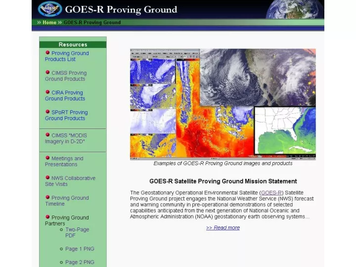
The GOES-R Proving Ground program engages the National Weather Service (NWS) and other state and local offices in pre-operational demonstrations of selected capabilities of the next-generation GOES-R satellite. This includes observations such as radiances, normalized vegetation index, land and sea surface temperatures, stability indexes, and more.

E N D
GOES-R Proving Ground The GOES-R Proving Ground engages NWS and other state and local offices in pre-operational demonstrations of selected capabilities of next generation GOES.
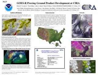
Radiances - Observed MODIS 7-bands Normalized Vegetation Index - MODIS Land surface temperature - MODIS Sea/Lake Surface Temperature - MODIS Total totals, K-index, Lifted Index Stability Indexes - MODIS Total Precipitable Water (MODIS) GOES CAPE Stability Indices GOES Convective Cloud Top Heights Radiances - Simulated NWP imager radiances Natural Color RGB - MODIS GOES Sounder Ozone Mesoscale Winds - GOES imager Stability Indexes - AIRS AVHRR Cloud-top type/temperature/phase/optical depth Satellite-NWP Sky Cover Conditional Stability Nearcasting Weather Event Simulator PG Products from CIMSS
GOES-R algorithm being demonstrated in operational AWIPS Convective Initiation/Cold Top Cooling Interaction with Sullivan (MKE) NWS Office CI likely CI occurring Lightning 05:02 UTC 04:30 UTC 06:30 UTC Forecaster generated screen captures from AWIPS at MKE. Product from UW/CIMSS Satellite product leads the radar signature 4
WES beta-version status (ABI radiances) Distributed more copies at the AMS annual meeting. Poster will be presented. Beta release packaged: This contains the June-04-05-2006 storm outbreak (CONUS and mesoscale), Hurricane Katrina, band differences, a beta release of WES guide, etc. Comments received 5
.MARINE...04Z TAMDAR SOUNDING VCNTY OF MKE SHOWING WINDS HAVE INCREASED TO 25KTS AT 2900 FT AROUND 04Z. ALONG WITH FORECAST SOUNDINGS FOR LATE THIS MORNING...THINKING SFC WNDS WITH GUSTS AOA 22KT MAY MIX DOWN TO LAKE SFC A LITTLE EARLIER. HENCE...MOVED SMALL CRAFT ADVISORY START TIME TO 16Z AS PRES GRADIENT TIGHTENS. GRADIENT BEGINS TO LOOSEN AS CDFNT SWEEPS IN FROM THE NORTH AFT 06Z/11. WL BE CLOSE TO RETURNING TO SMALL CRAFT ADVISORY LEVELS ON MONDAY IN LOW LEVEL COLD AIR ADVECTION BEHIND DEPARTING CDFNT. FINALLY SOME CLEARING OVER NEARSHORE WATERS. TERRA MODIS IMAGE FROM 1640Z/09 SHOWS CONSIDERABLE INCREASE IN ICEPACK OVER NEARSHORE WATERS. AREA FORECAST DISCUSSION NATIONAL WEATHER SERVICE MILWAUKEE/SULLIVAN WI 343 AM CST SUN JAN 10 2010
Sample Images TPW SST(Daytime) CTT
Area Forecast Discussion MAIN SHORT TERM FORECAST PROBLEM IS EAST FLOW AND MARINE LAYER INFLUENCE OVER EASTERN WISCONSIN...AND DENSE FOG POTENTIAL IN THE WEST. THINK MOST OF THE DENSE FOG WOULD BE IN THE RIVER VALLEYS...WITH A TENDENCY FOR PATCHY FOG AND SOME STRATUS AGAIN IN THE EAST WITH MORE OF A GRADIENT. MODIS 1 KM IMAGERY LAST NIGHT SHOWED THE DENSE FOG IN LONE ROCK AND BOSCOBEL WAS CONFINED TO THE IMMEDIATE WISCONSIN RIVER VALLEY...IMPORTANT INFORMATION. THE LOCAL RIVER VALLEY DENSE FOG IS NOT SEEN IN THE NORMAL 2 KM GOES. (HENTZ/MKX)
AVHRR in AWIPS • CIMSS continues to test and evaluate AVHRR imagery in AWIPS (individual channels, and derived cloud products) • Plan to begin distribution to NWS Central Region • VISITview training lesson
VISITview training lesson will be completed by the end of January