Download
1 / 33
330 likes | 522 Views
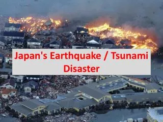
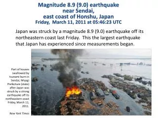
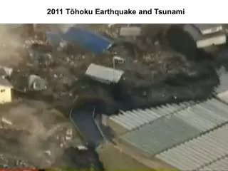
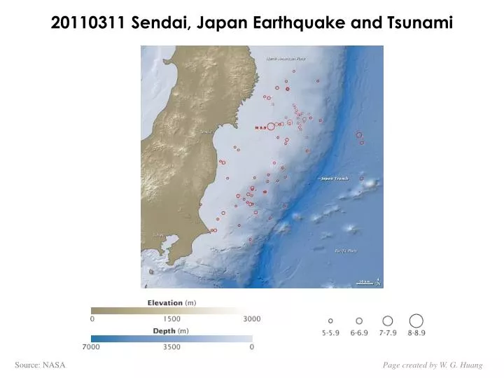
20110311 Sendai, Japan Earthquake and Tsunami. Source: NASA. Page created by W. G. Huang. Credit: JMA. Page created by W. G. Huang. The depth of the Pacific Ocean floor. Credit: NOAA. Tsunami Wave Height Model Shows Pacific-Wide Impact. Credit: NOAA.

E N D
20110311 Sendai, Japan Earthquake and Tsunami Source: NASA Page created by W. G. Huang
Credit: JMA Page created by W. G. Huang
The depth of the Pacific Ocean floor Credit: NOAA
Tsunami Wave Height Model Shows Pacific-Wide Impact Credit: NOAA
How Shifting Plates Caused the Earthquake and Tsunami in Japan Source: U.S. Geological Survey Page created by W. G. Huang
Credit: NOAA Page created by W. G. Huang
Source: NOAA Page created by W. G. Huang
Swirling waves on the coast at Oarai, Ibaraki prefecture Photograph: AP Credit: Guardian Unlimited Page created by W. G. Huang
A tsunami wave washes away buildings in Sendai, Miyagi prefecture Photograph: Keystone/Rex Features Credit: Guardian Unlimited Page created by W. G. Huang
People on top of a building at Sendai airport Miyagi prefecture as cars, planes and debris are swept past Photograph: Kyodo/Reuters An office building on fire in Tokyo Photograph: Kyodo/Reuters Credit: Guardian Unlimited Page created by W. G. Huang
Water surges through Iwaki, Fukushima prefecture Photograph: AP Credit: Guardian Unlimited Page created by W. G. Huang
Houses ablaze in Natori city, Miyagi prefecture Photograph: AFP/Getty Images Credit: Guardian Unlimited Page created by W. G. Huang
Water surges through part of Kesennuma city in Miyagi prefecture Photograph: AFP/Getty Images Credit: Guardian Unlimited Page created by W. G. Huang
The sea engulfs homes in Natori, Miyagi prefecture Photograph: Keystone/Rex Features Credit: Guardian Unlimited Page created by W. G. Huang
Natural gas storage tanks burn at the Cosmo oil refinery, Ichihara, Chiba prefecture Photograph: Reuters Credit: Guardian Unlimited Page created by W. G. Huang
The Fukushima Nuclear Power Plant Aerial view of the plant The Fukushima Nuclear Power Plant Page created by W. G. Huang
This is a satellite image of Japan showing damage after an Earthquake and Tsunami of the Kengaya bridge Credit: DigitalGlobe Page created by W. G. Huang
This is a satellite image of Japan showing damage after an Earthquake and Tsunami at the Fukushima Dai-Ni Nuclear Power plant. Credit: DigitalGlobe Page created by W. G. Huang
This is a satellite image of Japan showing damage after an Earthquake and Tsunami at the Fukushima Dai-Ichi Nuclear Power plant. Credit: DigitalGlobe Page created by W. G. Huang
This is a satellite image of Japan showing damage after an Earthquake and Tsunami at the Sendai Port, Japan. Credit: DigitalGlobe Page created by W. G. Huang
This is a satellite image of Japan showing damage after an Earthquake and Tsunami at the Kirin Plant, Sendai. Credit: DigitalGlobe Page created by W. G. Huang
2004 年蘇門達臘地震所觸發之巨大海嘯 Running for their lives!!! Map credit: http://www.asiantsunamivideos.com/ Page created by W. G. Huang
2004年12月26日南亞地震海嘯可侵入內陸達四公里2004年12月26日南亞地震海嘯可侵入內陸達四公里 Page created by W. G. Huang
Banda Aceh Shore 海嘯前(攝於2004年6月23日)與海嘯後(攝於2004年12月28日)之衛星影像 Image Credit: “DigitalGlobe” Page created by W. G. Huang
Banda Aceh Shore 海嘯前(攝於2004年6月23日)與海嘯後(攝於2004年12月28日)之衛星影像 Image Credit: “DigitalGlobe” Page created by W. G. Huang
Kalutara Water Detail (斯里蘭卡) 海嘯前(攝於2004年1月1日)與海嘯入侵前之退潮(攝於2004年12月26日)之衛星影像 150 公尺 首都 可倫波 Kalutara Image Credit: “DigitalGlobe” Page created by W. G. Huang
2004 年蘇門達臘地震的死亡人數:298,055 孟加拉 2 阿拉伯海 孟加拉灣 緬甸 59 泰國 8,506 印度 16,389 斯里籣卡 43,832 馬爾地夫 82 東非 137 馬來西亞 74 印尼 228,948 Map Credit: Guardian Unlimited Page created by W. G. Huang
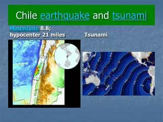
1900年以來發生於世界各地的大地震 Maule, Chile 2010 02 27 Mw 8.8 Sandai, Japan 20110311 Mw 8.8 Source: USGS Page created by W. G. Huang
海嘯 (Tsunami) 海嘯的英文通常被稱為Tsunami (發音: soo-NAH-mee),來自日語「津波」,”tsu”指港口(harbor) ,”nami”指波浪(waves)。目前已愈來愈少人使用tidalwave,以便和潮汐作區別。海嘯是指海洋中綿延數百公里的波浪,在廣闊的深海大洋中其行進速度最快可高達每小時1000公里左右,2004年12月26日印尼蘇門答臘地震所引發的海嘯在75分鐘內便前進了600公里(亦即時速480公里/小時)。海嘯在靠近淺水區的速度則驟降,可疊加形成高度達數十公尺的水牆,這些水牆對海岸地區的衝擊往往能釀成巨大的傷亡。 Page created by W. G. Huang
Tsunami Generation: This animation by Prof. Miho Aoki from the University of Alaska Fairbanks Art Department provides a very nice look at how a tsunami can be generated by a subduction zone earthquake.
Earthquake-generated tsunamis • Seafloor deformed by earthquake • Wave initiated with small amplitude and high speed in deep water • Speed decreases and amplitude increases in shallow water Page created by W. G. Huang
海嘯和一般的風所引起海浪兩者有許多的不同,主要的差異在於它們的來源,速度與尺度的大小海嘯和一般的風所引起海浪兩者有許多的不同,主要的差異在於它們的來源,速度與尺度的大小 Tsunamis and normal waves are many differences between the two. The primary differences are size, speed and source. Page created by W. G. Huang
Pacific Tsunami Warning Center PTWC Alaska Tsunami Warning Center ATWC Alaska DART station The PTWC was established in 1948, following the 1946 tsunami in Hawaii that left more than 150 people dead. The ATWC was established in 1967 as a result of the 1964 9.2 earthquake in Alaska that left 132 dead—122 of those deaths have been attributed to the tsunami that was generated. Hawaii Pacific Tsunami Warning Center PTWC 黃色表地震帶 Photo courtesy DART Map Credit : U.S. National Oceanic & Atmospheric Administration (NOAA) and U.S. National Tsunami Hazard Mitigation Program Page created by W. G. Huang