Download

1 / 26
320 likes | 665 Views
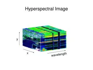
Hyperspectral Image preprocessing. Contact: mirza.waqar@seecs.edu.pk. Mirza Muhammad Waqar. Contents. Georeferencing Hyperspectral Data Radiometric Calibration Minimum Noise Fraction (MNF), Transformation Principal Component Analysis (PCA) Pixel Purity Index (PPI).

E N D
Hyperspectral Image preprocessing Contact: mirza.waqar@seecs.edu.pk Mirza Muhammad Waqar
Contents • Georeferencing Hyperspectral Data • Radiometric Calibration • Minimum Noise Fraction (MNF), Transformation • Principal Component Analysis (PCA) • Pixel Purity Index (PPI)
Georeferencing Hyperspectral Data • Because all of the airborne sensors described are either • pushbroom or whiskbroom scanners, • They all require a direct georeferencing system in order to reconstruct a • coherent, geometrically-correct, 2-dimensional image.
Radiometric Calibration • Radiometric error may be introduced into reflectance values measured by the sensor from two environmental sources: • the atmosphere • the terrain slope and aspect. • The atmosphere obviously has absorption characteristics that will alter the spectral signature seen by an airborne or spaceborne sensor of a remotely sensed object on the ground.
Cont… • These effects will vary over time and space because the composition of the atmosphere between the sensor and the target varies over time and space. • The most important atmospheric constituents to consider are • water vapor • carbon dioxide • Ozone • nitrous oxide • Methane • carbon monoxide • oxygen.
Cont… • Jensen (2007) states that "only when training data from one time or place must be extended through space and/or time is atmospheric correction necessary for image classification and many types of change detection." • If training samples are extracted from the dataset to be classified, then atmospheric correction may be unnecessary, as the training set and the data to be classified are influenced equally by the atmosphere.
Cont… • Furthermore, if change detection is to be performed from two thematic classifications, • atmospheric correction may not be necessary • as long as the training sets for each classification were drawn from the dataset to be classified. • In hyperspectral image analysis, it is also important to recognize that some materials can be identified by their absorption characteristics in a particular spectral band, not just by their reflectance.
Cont… • On the other hand, radiometric calibration, including atmospheric correction, becomes much more important • particularly in hyperspectral data analysis, when one is trying to match • the remotely sensed spectral signatures to • spectral libraries created independently in a laboratory or using field spectrometers. • In this case, not only must the spectrometers themselves be calibrated for radiometric accuracy, but atmospheric effects may need to be removed to correctly identify the remotely sensed signatures
Cont… • Even if ground measurements are obtained at the same time as the remote sensing data. • They probably are not affected by the same atmospheric or bi-directional reflectance effects as the corresponding pixel in the airborne or spaceborne dataset.
Assignment - Atmospheric Correction Models • Flat Field Correction • Internal Average Relative Reflectance (IARR) • Empirical Line Calibration • Automated atmospheric removal program (ARM)
Flat Field Correction • The Flat Field Correction method normalizes images • to an area of known “flat” reflectance (Goetz and Srivastava, 1985; Roberts et al., 1986). • The average AVIRIS radiance spectrum from the ROI is used as the reference spectrum, which is then divided into the spectrum at each pixel of the image.
Internal Average Relative Reflectance (IARR) • Used to convert raw DN values to relative reflectance. This is done by dividing each pixel spectrum by the overall average spectrum. • The IARR calibration method normalizes images to a scene average spectrum. • Apparent reflectance is calculated for each pixel of the image by dividing the reference spectrum into the spectrum for each pixel.
Cont… • This is particularly effective for reducing imaging spectrometer data to relative reflectance • in an area where no ground measurements exist and little is known about the scene (Kruse et al., 1985; Kruse, 1988).
Empirical Line Calibration • The Empirical Line correction method forces image data to match • selected field reflectance spectra (Roberts et al., 1985; Conel et al., 1987; Kruse et al., 1990).
Topographic Normalization • When performing spectral analysis in images acquired in variable terrain, the effects of • Relief • Slope • Aspect • should also be considered. • Shadows are dependent on the • Angle of incident light • Orientation of the terrain with respect to that light.
Cont… • A good terrain model, along with the • Time and date of the imagery Can be used to algorithmically reduce or eliminate topographically induced variations in reflectance. • This can be important in the classification of a single image, as it can create differences between the training samples and areas in the image to be classified • For example, a constant type of forest stand can have a different appearance on different terrain slopes (Jensen, 2005).
Minimum Noise Fraction Transformation (MNF) • Hyperspectral Imaging generates vast volumes of data. • 100s or more bands might not be necessary to identify and separate the surface materials of interest to a particular study. • Furthermore, some bands might contain more noise than others, making them more of a detriment than an aid to the analysis.
Cont… • Eliminating noise and reducing the spectral dimensionality of the data are the goals of • Principal Component Analysis (PCA) • Minimum Noise Fraction Transformation (MNF). • Information contained in individual hyperspectral bands may be, in some regions of the spectrum, highly redundant.
Cont… • The many redundant bands may be collapsed into a much smaller set of MNF bands • without losing the critical information needed to differentiate or identify surface materials. • Furthermore, the noise can also be identified and eliminated using the same methods.
Note • MNF results are applicable to that particular dataset or others with very consistent and similar spectral characteristics. • If a project involves many hyperspectral images collected over a large area, the MNF results from one image or set of images may not apply to others in the project.
Pixel Purity Index Mapping (PPI) • Imagine how much more difficult it would be to identify appropriate pixels or groups of pixels with ideal hyperspectral signatures. • Use Pixel Purity Index(PPI) to find the most spectrally pure (extreme) pixels in multispectral and hyperspectral images.
Pixel Purity Index(PPI) to find the most spectrally pure (extreme) pixels in multispectral and hyperspectral images.
Hyperspectral Data Acquisition Raw Radiance Data Spectral Calibration At-Sensor Spectrally Calibrated Radiance Spatial Pre-Processing and Geocoding Radiometrically and Spatially processed radiance image Atmospheric Correction, solar irradiance correction Geocoding reflectance image Feature Mapping Data analysis for feature mapping Absorption band characterization Spectral feature fitting Spectral Angle Mapping Spectral Unmixing Minral Maps