Download
1 / 38
380 likes | 386 Views
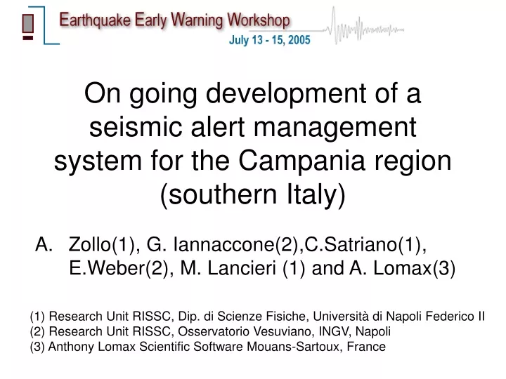
On going development of a seismic alert management system for the Campania region (southern Italy). Zollo(1), G. Iannaccone(2),C.Satriano(1), E.Weber(2), M. Lancieri (1) and A. Lomax(3). (1) Research Unit RISSC, Dip. di Scienze Fisiche, Università di Napoli Federico II

E N D
On going development of a seismic alert management system for the Campania region (southern Italy) Zollo(1), G. Iannaccone(2),C.Satriano(1), E.Weber(2), M. Lancieri (1) and A. Lomax(3) (1) Research Unit RISSC, Dip. di Scienze Fisiche, Università di Napoli Federico II (2) Research Unit RISSC, Osservatorio Vesuviano, INGV, Napoli (3) Anthony Lomax Scientific Software Mouans-Sartoux, France
Outline HOW WHAT WHY • WHY an earthquake early warning system in southern Italy • WHAT are the system architecture and components • HOW does it work
SAMS: A Seismic Alert Management System for the Campania Region HOW WHAT WHY A pilot project to experiment a system for earthquake early warning and rapid evaluation of ground motion scenarios in the Regione Campania Objectives: • Early-Warning and Rapid Ground shaking scenarios • Remote control and protection of a selected target Time Schedule: end 2005 real-time seismic network completion end 2006 upgrade data transmission system Financial support: Campania Region - Department of Civil Protection AMRA Regional Center for Analysis and Monitoring of Environmental Risks
Regional historical seismicity HOW WHAT WHY Campania Region Tyrrenian sea
Ground shaking during the 1980, Irpinia Earthquake, Ms=6.9 HOW WHAT WHY Peak accelerations & velocities modified from Cabanas et al., 1998 Intensity map, modified from De Rubeis et al., 1996
Recent earthquake activity HOW WHAT WHY INGV catalogue (1981-2002), M>2.5
Rate of occurrence HOW WHAT WHY southern Apennines Probability map of moderate to large earthquakes (M5.5) in Italy for the next 10 years (Cinti et al., G3, 2005)
Potential targets for an EWS in Campania region city of Napoli 4 small towns hospitals railways highways industries gas/electric pipelines fire stations HOW WHAT WHY
Peculiarities / criticalities HOW WHAT WHY • Moderate events (M4.5) are of interest social impact, loss of occupancy • Short hypocentral distances narrow “early warning” windows • Multiple rupture events complexity/ reliability of location/magnitude estimations
EEW seismic network & seismicity “Shake map” network “Early warning” network HOW WHAT WHY
Network architecture Stations Sub-nets Local Control Centers HOW WHAT WHY Three levels of data acquisition and transmission: > Stations (data loggers) > Local Control Center (sub-nets) > Network Control Center (Naples)
Communications 7-23 GHz 55-150 Mbps 2.4 GHz 54 Mbps HOW WHAT WHY Data transmission system: data logger LCC: point-to-point Wireless LAN bridge LCC LCC : backbone (SDH) / ADSL LCC Network center (Naples): backbone (SDH) / ADSL
Fonctionality HOW WHAT WHY • Local Control Center: Fully automated. Manages and processes the sub-net data (seedlink protocol & Earthworm data management system) • Data logger: on-site computational capabilities (event detection, automatic P time, peak amplitude, P-frequency,..) Local Control Center Seismic station
The seismic instruments HOW WHAT WHY Embedded Linux and Open Source Software 24-bit AD converter Removable mass storage (2 PCMCIA slots 5Gb) ARM720T processor, supervisory system 6 channels: 3 accelerometers + 3 seismometers (Short Period or Broad Band)
Operational mode EQK HOW STA1 WHAT LCC1 WHY • Event detection (STA1) • LCC1 linked to the closest station, verifies the event coincidence, collects and processes P-waveform data (time, amplitude, ..) • LCC1 estimates the hypocenter location and magnitude with errors (X, DX, M, DM) • New data entries from progressively distant stations LCC1 updates estimates of X,DX,M,DM • Alert notifications to end-users is sent after each up-dating step
Characteristic times for EEW HOW WHAT WHY Latency/computational time T_first_P T_S_target To 1.5 – 3.5 sec for eqk at depths of 4-16 km 3-5 sec
Source parameter estimates TPmax (4sec) Bagnoli (22 km) Calitri(20 km) Tpmax 1980 Irpinia earthquake Ms=6.9 HOW WHAT M WHY • Moment/Magnitude: • P and early-S max amplitudes • v^2 plots • instantaneous period • Location: • Trigger station order (Voronoi cells) • Equal differential time (Lomax,2004) Allen & Kanamori,2003
P-wave detection capability vs time To + 3 sec To + 4 sec To + 5 sec To + 6 sec HOW WHAT WHY At each time step, the map shows the number of stations which would record the first-P wave of an earthquake occurring at 12 km depth beneath the network
Evolutionary earthquake location 1/4 HOW WHAT WHY stations (operational) hypocenter Voronoi cell boundaries wavefront
Evolutionary earthquake location 2/4 HOW WHAT WHY First station detects arrival – constraint is Voronoi cells “conditional” EDT surface volume defined by stations without arrivals B A
Evolutionary earthquake location 3/4 HOW WHAT WHY Wavefront expands – EDT surfaces deform, constraint improves “conditional” EDT surface B A
Evolutionary earthquake location 4/4 HOW WHAT WHY Second station detects arrival – constraint includes EDT surface “true” EDT surface B A
Voronoi cells of Irpinia network HOW WHAT WHY Voronoi cells give the location of the eqk epicenter (no depth!) constrained by a single station trigger
Real time eqk location: Simulation HOW WHAT WHY The plotted quantity is proportional to the probability of earthquake location at a given point Map at 12 km depth Tnow=0.0 is the time of first-P at the closest station
Real time eqk location: Simulation HOW WHAT WHY
Real time eqk location: Simulation HOW WHAT WHY Second station detects P-arrival
Real time eqk location: Simulation HOW WHAT WHY
Real time eqk location: Simulation HOW WHAT WHY
Real time eqk location: Simulation HOW WHAT WHY
Real time eqk location: Simulation HOW WHAT WHY
Real time eqk location: Simulation HOW WHAT WHY
Real time eqk location: Simulation HOW WHAT WHY
Real time eqk location: Simulation HOW WHAT WHY
Real time eqk location: Simulation HOW WHAT WHY
Real time eqk location: Simulation HOW WHAT WHY P-wave arrives at nine stations within 2 sec from the first-P at the closest station
Real time eqk location: Simulation HOW WHAT WHY
Real time eqk location: Simulation HOW WHAT WHY
Conclusions • A high-density, high dynamics (strong motion + seismometers) seismic network is under installation in Campania region for “regional” early-warning applications • The main targets are strategic infrastructures located at distances such that expected S-wave lead time is around 20-30 sec • The network architecture is designed to have distributed levels of data storage, communication and decisions • On going development of methods for earthquake location, magnitude estimation. Need to provide parameter uncertainty variation with time engineering structural control • An example: the evolutionary earthquake location approach