Download
1 / 33
330 likes | 569 Views
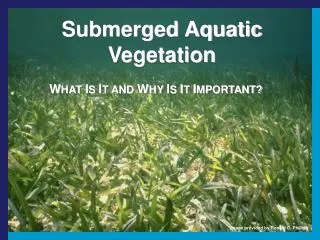
An Overview of Monitoring Submerged Aquatic Vegetation in Coastal North Carolina. Dean E. Carpenter, D. Env . Albemarle-Pamlico National Estuary Program Eastern North Carolina Environmental Conference 10 May 2012. SAV Questions.

E N D
An Overview of Monitoring Submerged Aquatic Vegetation in Coastal North Carolina Dean E. Carpenter, D. Env. Albemarle-Pamlico National Estuary Program Eastern North Carolina Environmental Conference 10 May 2012
SAV Questions • What is APNEP’s role in natural resources conservation in general and SAV conservation in particular? • How does SAV Partnership’s monitoring and assessment activities address SAV resources? • What are the particular technologies being developed and applied for SAV monitoring in coastal North Carolina?
Albemarle-Pamlico Estuarine System: Nation’s Second Largest Estuary Chesapeake Bay Albemarle Sound Pamlico Sound Cape Hatteras Cape Lookout
APNEP Mission “To identify, restore, and protect the significant resources of the Albemarle-Pamlico estuarine system.”
2012-2022 Comprehensive Conservation Management Plan • CCMP Outcomes • Ecosystem Outcome 2b: The extent and quality of upland, freshwater, estuarine, and near-shore marine habitats fully support biodiversity and ecosystem function. • CCMP Actions • Protection Action B2.2: Develop and implement a submerged aquatic vegetation (SAV) protection strategy. APNEP will work with its partners in protecting SAV habitats through mapping efforts, examination of permitting requirements, water quality and habitat issues, and education for boaters. • Restoration Action C3.3: Develop and implement a submerged aquatic vegetation restoration strategy. In conjunction with strategies to protect SAV (see B2.2), APNEP will work to restore areas capable of supporting SAV. This work will require study of effective restoration techniques, bathymetric mapping, water quality monitoring, and other efforts. APNEP will continue its contributions to the SAV Partnership to develop and promote a SAV restoration strategy.
SAV Partnership • Federal: ACE, FWS, NOAA, NPS, NRCS • Mixed: APNEP, NERR • State: DCM, DMF, DWQ, DWR, EEP, WRC, DOT • Academia: ECSU, ECU, NCSU, UNC-CSI, UNC-IMS, UNC-W, NC Sea Grant, DUML, CW&M-VIMS • NGOs: NCCF, TNC
The First Complete* Mapping of North Carolina’s Submerged Aquatic Vegetation Resources Don Field NOAA – NOS - NCCOS Center for Coastal Fisheries and Habitat Research Beaufort, NC
Monitoring and Mapping Objective Monitor and map the distribution and abundance of Submerged Aquatic Vegetation (SAV) in North Carolina’s and southeastern Virginia’s estuarine and coastal waters. The network will cover the waters from Back Bay, VA, to the NC/SC boundary.
Environmental Parameters for Submerged Habitat Mapping • Winds low – preferably 5 mph or less • Sun Angle 20 – 45 degrees to reduce glint • Low tide • Turbidity low • No clouds or haze • Adequate biomass of target
2007 Monitoring Activities • Resources: APNEP, FWS, DMF • NOAA IDIQ Contract Mechanism • Flights: Aerometric, Dewberry • Water Clarity Volunteer Network (Chappell-DMF) • 25 citizens: secchi depth • Ground Truth Network (Conrad – DMF)
Aerial Monitoring Phases • Image acquisition: Intergraph’s Z/I Digital Mapping Camera (DMC) • 24K feet above mean terrain • 1 m pixel resolution – 4 bands – Blue, Green Red and Near IR • Photogrammetric control coordination: airborne GPS + ground-based GPS receivers • Softcopy aero-triangulation • Digital imagery orthorectification using DEMs
Field Verification Parameters: Autumn 2007 • Position • Water Clarity • Temperature • Salinity • Depth • Species Identification • SAV Density
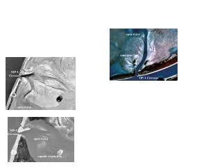
2007 Field Verification Points • 1056 random points visited (82% by DMF) • Points selected from areas where SAV was previously mapped or areas not previously mapped down to depth of 2m • Points visited with small boats, SAV visualized from boats when possible, wading when possible and rakes when water too deep and too turbid.
Autumn 2007 Spring 2008 Acquisition • 1,795.45 flight line miles • 1,347 images • Bogue, Back, and the mainland side of Core Sounds from 2006 – 0.3 m pixel size flown at 10,000 ft.
Manual On-Screen Digitization of SAV Polygons • Initially by DMF Personnel • NOAA – Bogue Inlet to Oregon Inlet • APNEP funded contract to finish off all other areas
Note….one less zero 250,000 200,000 150,000 100,000 50,000 Acres 138,741 acres
Oregon Inlet to Cape Lookout • -86,103 acres • 71% of State Total
Area South of Oregon Inlet • Length – 20 miles • Width – 4 miles • Total Area – 28,642 acres • 7th most SAV “State”
SAV in NC and Back Bay, VA 2006-2008 http://portal.ncdenr.org/web/apnep/resources/maps
Where Do We Go From Here? • Already at the five-year period from the initial acquisitions • Monitoring – NOAA, ECU, NCSU, APNEP obtained a CRFL grant to try to develop a statewide monitoring program • Challenges • Aerial surveys only in coastal regions • Inland regions must be surveyed on-the-ground (“invisible grass”) • SAV is highly seasonal • N. limit of Halodulewrightii • S. limit of Zostera marina • SAV is located in high and low salinity areas (APNEP 2011)
Developing Protocols in high-turbidity submerged aquatic vegetation (SAV) beds in North Carolina's estuaries using single-beam sonar and low-light video Cecilia S. Krahforst1, Joseph J. Luczkovich1, Christine Buckel2, Don Field2, Richard W. Curran1, Dean E. Carpenter3,Gayle R. Plaia4, W. Judson Kenworthy2 1 East Carolina University 2 National Oceanic and Atmospheric Administration 3 Albemarle-Pamlico National Estuary Program 4 North Carolina State University
SONAR Method Ping Number Target Strength (dB) Depth (m)
Video Method • High resolution low light camera • Differential GPS • Continuous stamped video – date, time & location • Camera fixed 13cm above bottom • Frame size ~0.25m2 • Individual frames classified for SAV presence/absence
2012 APNEP Ecosystem AssessmentCoasts, Sounds, Near Marine: Extent & Pattern • Extent of Submerged Aquatic Vegetation • Why Is the Extent of the Submerged Aquatic VegetationImportant? • What DoesThis Indicator Report? • What Do the Data Show? • Why Can’t This Entire Indicator Be Reported at This Time? • Understanding the Data • Technical Notes
Manage SAV Adaptively • Most difficult step? • Senior management engagement • Trigger levels in plan
Acknowledgements Don Field Jud Kenworthy Christine Buckel Joe Luczkovich Cecilia Krahforst Dave Eggleston Anne Deaton