Download
1 / 32
320 likes | 449 Views
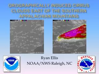
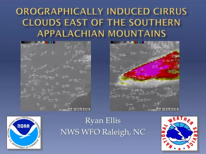
Orographically Induced Cirrus Clouds East of the Southern Appalachian Mountains. Ryan Ellis NWS WFO Raleigh, NC. Motivation.

E N D
Orographically Induced Cirrus Clouds East of the Southern Appalachian Mountains Ryan Ellis NWS WFO Raleigh, NC
Motivation • The development of orographically induced cirrus clouds east of the southern Appalachian Mountain chain can result in areas of unanticipated cloudiness downstream across the Carolinas and Virginia. • Adverse effect on forecast accuracy • Quantify environmental conditions • Address Null Cases • Create a forecasting technique for operations
Data • 24 (N=40) cases from 2009-2010 • 43 (N=87) cases from 2011-2012 (N=events covering more than one station ie: cirrus at KGSO and KRNK in same day) • 344 Null Case Soundings (soundings representative of orographic cirrus environment with no cirrus occurring)
Case Study 10/29/08 IR satellite pictures showing conditions before a cirrus outbreak, and after the onset, just four hours later.
Satellite Imagery Visible and water vapor imagery depicting the 10/29 outbreak. A fetch of moisture can be seen upstream of the cirrus. Areas of enhanced moisture can be seen in the flow. These are believed to act as catalysts in setting off an event like the one shown.
500 mbGeopotential Height 500 mbgeopotential height pattern for 10/29/08 showing a typical setup for orographic cirrus including the low centered over New England and a strong ridge to the west. This is typically known as a “Northwest Flow Pattern”
GSO Sounding Tropopause Increasing Wind Speed and Slight Backing With Height From Top of Inversion to Tropopause InversionTarget Range Top of Inversion GSO sounding for 10/28 showing the main inversion from about 850mb to 800 mb with a secondary inversion and near isothermal layer above. Winds are backing slightly with height and increasing in speed up to the tropopause. The 00z sounding is usually more beneficial to analyze given the diurnal pattern identified. This is also an opportunity to use the Eastern Region enhanced short term forecast process.
Events vs. Non-Events GREEN = Cases RED = Non-Cases
Forecasting Process • When diagnosing an outbreak, analyze sounding data first for orographic cirrus trademarks. • Next look at water vapor imagery for an upstream moisture fetch. Enhancements in the moisture are potential catalysts for orographic events. • Check angle of flow with respect to ridge axis. Orthogonal flow usually creates larger, more expansive outbreaks that affect the temperature most. • Adjust sky cover and temperature forecasts as needed in an enhanced short term forecasting mode.
Conclusions • Orographic cirrus outbreaks can affect temperature forecasts by as much as 10˚F. • Outbreak events usually set up in a stable environment with a mid to upper level low pressure system to the northeast and a strong upper level ridge to the west. • An inversion typically exists between 850 and 700 millibars. • Winds are generally unidirectional from the northwest with some slight backing throughout the profile from the top of the inversion to the tropopause.
Conclusions • A pre-existing upstream moisture source is usually necessary to trigger the onset of an orographic cirrus outbreak. • Lack of upstream moisture source and incorrect synoptic pattern are the biggest reasons for null cases. • Atmospheric soundings can be used to access the susceptibility of the environment to orographic cirrus. • Infrared and water vapor imagery can be used to identify moisture fetches and their likelihood of producing orographic cirrus events within the enhanced short term forecasting mode.
Forecasting Guide http://www.erh.noaa.gov/rah/science/rah.orographic.cirrus.forecasting.guide.pdf Ryan.Ellis@noaa.gov
Future Work • Publish journal article on the findings of the research to this point. • In the future we would like to attempt to compile verification statistics for temperature and cloud cover data during orographic cirrus outbreaks.
References • Conover, J.H., 1964: The Identification and Significance of Orographically Induced Clouds Observed by TIROS Satellites. J. Appl. Meteor., 3, 226-234. • Durran, D.R., 1986: Another Look at Downslope Windstorms. Part I: The Development of Analogs to Supercritical Flow in an Infinitely Deep, Continuously Stratified Fluid. J. Atmos. Sci., 43, 2527-2543. • Ellrod, G. 1983: Orographic Cirrus Along the Appalachian Mountains. U.S. Department of Commerce Satellite Applications Information Note. 83/2, 8-C-1 – 8-C-5.
Acknowledgements Lindsey Anderson – North Carolina State University Jonathan Blaes – SOO WFO Raleigh, NC