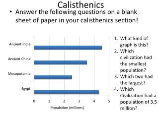
Download
1 / 14
140 likes | 296 Views
Calisthenics. Longitude and latitude are used to: a. Tell the difference between cultures. b . Locate places on a world map. c . Navigate rivers. d . Get from one highway to another . Latitude is labeled: a. North and East b . West and South c . North and South

E N D
Calisthenics • Longitude and latitude are used to: a. Tell the difference between cultures. b. Locate places on a world map. c. Navigate rivers. d. Get from one highway to another. • Latitude is labeled: a. North and East b. West and South c. North and South d. East and West • Longitude goes from: a. North to East b. West to South c. North to South d. East to West
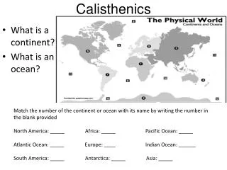
SWBAT define, identify and use political maps, physical maps and resource maps. Describe the differences between political, physical and resource maps and know when to use them.
Political Map • A Political Map shows the boundaries and locations of political units. • Political units are communities that are united under a government. • Countries, states, counties, cities, and towns are political units. Many features depicted on a political map are made by humans.
Physical Map • Physical Maps: A physical map shows the location and the topography, or shape, of the Earth’s geographic forms. • You use the SCALE to find the elevation.
How do you tell the difference! • How to tell the difference between a physical and political map: • Identify what the map is showing. • Ask: Is the main focus of the map made by humans or nature? • Made by humans? ➔ Political Map • Made by nature? ➔ Physical Map
Resource Maps Resource maps show thenatural resources found in a region. Use themap key to find the location of resources.