Download
1 / 21
210 likes | 376 Views
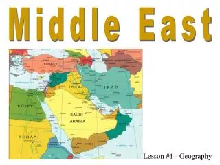
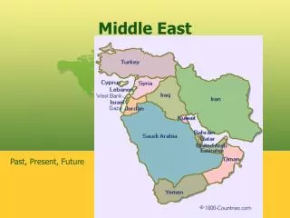
Brett Kohler and N athan Woods. Middle East digital atlas. Table O’ Contents. Section 2 Euphrates River Jordan River Tigris River Suez Canal Persian Gulf Strait of Hormuz Arabian Sea Red Sea Gaza Strip. Section 1 Map of Political Features Afghanistan Iran Iraq Israel

E N D
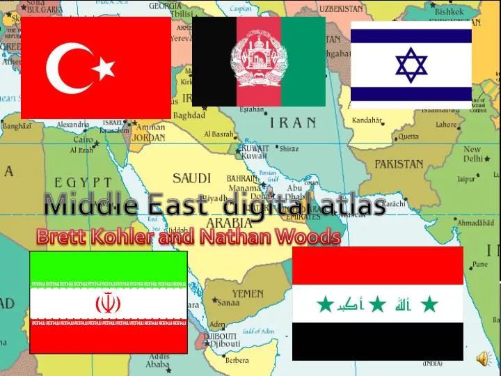
Brett Kohler and Nathan Woods Middle East digital atlas
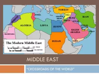
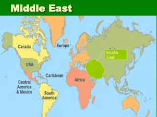
Table O’ Contents Section 2 Euphrates River Jordan River Tigris River Suez Canal Persian Gulf Strait of Hormuz Arabian Sea Red Sea Gaza Strip Section 1 Map of Political Features Afghanistan Iran Iraq Israel Saudi Arabia Turkey
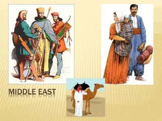
Map of political features Israel
Afghanistan • Government Type- Islamic Republic • Capital – Kabul • Independence day – August 19, 1919 • Religions - Sunni Muslim 80%, Shia Muslim 19%, other 1% • Population - 29,835,392 (July 2011 est)
Iran • Capital - Tehran • Government type - theocratic republic • Republic Day - April 1 , 1979 • Religion - Muslim 98%, other 2% • Population - 77,891,220 (July 2011 est.)
Iraq • Government Type - Parliamentary Democracy • Capital – Baghdad • Republic Day - July 14, 1958 • Religion - Muslim 97%, Christian or other 3% • Population - 30,399,572 (July 2011 est.)
Israel • Government Type - Parliamentary Democracy • Capital – Jerusalem • Independence Day – May 14, 1948 - from under British administration • Religion - Jewish 75.6%, Muslim 16.9%, Christian 2%, Druze 1.7%, other 3.8% • Population - 7,473,052 (July 2010 est.)
Saudi Arabia • Government Type – Monarchy • Capital – Riyadh • Independence Day – September 23, 1932 • Religion - Muslim 100% • Population - 26,131,703 (July 2011 est.)
Turkey • Government Type - Republican Parliamentary Democracy • Capital - Ankara • Republic Day, October 29, 1923 • Religion - Muslim 99.8%, other 0.2% • Population - 78,785,548 (July 2011 est.)
Euphrates river • -In 1990, the Atatürk Dam, the first in the Southeastern Anatolia project in Turkey, was completed. • - Plans ultimately call for 22 dams on the Tigris and Euphrates that altogether will provide enough water to irrigate over 3,700,000 acres (1.5 million hectares) of land • - This huge diversion of water in Turkey may have serious implications for other countries, such as Syria and Iraq, that rely on the river. • - The middle Euphrates traverses a wide floodplain in Syria, where it is used extensively for irrigation • - Euphrates Dam, 230 ft (70 m) high, constructed with Soviet aid at Tabqa, N Syria, is the main unit of the Tabqa Barrage Scheme. • - Below the dam the Euphrates receives the Belikh and Khabur rivers, its only major tributaries.
Jordan river • - river, c.200 mi (320 km) long, formed in the Hula basin, N Israel, by the confluence of three headwater streams and meandering S through the Sea of Galilee to the Dead Sea; the region of Palestine's longest and most important river and the world's lowest river below sea level. • - It flows through the northern section of the Jordan trough, a part of the Great Rift Valley; between the Sea of Galilee and the Dead Sea, the Jordan valley is called the Ghor. • - There it forms the border between Israel and the West Bank (W) and the nation of Jordan (E). • - The Jordan is fed by many small streams, with headwaters in Syria and Lebanon. • - Deep and turbulent during the rainy season, the Jordan is reduced to a sluggish, shallow stream during the summer.
Tigris river • - Tigris , river of SW Asia, c.1,150 mi (1,850 km) long, rising in the Taurus Mts., E Turkey, and flowing SE through Iraq to join the Euphrates River, with which it forms the Shatt al Arab. • - The Tigris is called the Hiddekil in the Bible • - It flows swiftly and receives many tributaries, including the Diyala, originating in the Zagros Mts., and the Great and Little Zab. • - The lower Tigris is connected to the Euphrates by semipermanent natural channels and by ancient canals • - Much of the marshland along the lower Tigris was drained in the early 1990s; restoration began in 2003.
Suez canal • - On 26 July 1956, before 100,000 Egyptians in the main square of Alexandria, Egyptian President Gamal Abdul Nasser announced his decision to nationalize the Suez Canal Company. • - This came as a rebuff to the recent withdrawal of the United states and Great Britain from their pledge to finance the construction of a high dam across the Nile River near Aswan. • - The Suez Canal lay formally under Egyptian sovereignty, but the implementation of these sovereign rights was regulated by an international convention agreed upon by Egypt and several maritime powers in 1888 in Constantinople. • - The revenue and daily administration of navigation through the canal were handled by an international company based in pairs and owned mainly by British and French shareholders. • - There was nothing illegal in the act of nationalization, since Nasser promised to compensate the shareholders faithfully and ensure there was no disruption of navigation.
Persian gulf • - Persian gulf of the Arabian Sea, 90,000 sq mi (233,100 sq km), between the Arabian Peninsula and Iran, extending c.600 mi (970 km) from the Shatt al Arab delta to the Strait of Hormuz, which links it with the Gulf of Oman. It is called the Arabian Gulf in the Arab world. • -The Persian Gulf, called the Arabian Gulf by the Arabs, is mostly shallow and has many islands, of which Bahrain is the largest • -The gulf is bordered by Oman and the United Arab Emirates to the south, to the west by Qatar and Saudi Arabia, to the north by Kuwait and Iraq, and along the entire east coast by Iran. • -It was generally thought that the gulf had previously extended farther north and that sediment dropped by the Tigris, Euphrates, Karun, and Karkheh rivers filled the northern part of the gulf to create a great delta • -But geologic investigations now indicate that the coastline has not moved and that the marshlands of the delta represent a sinking of the earth's crust as the Arabian land block pushes under Iran.
Strait of hormuz • -- Ninety percent of oil exported from Middle East Gulf producers is carried through the strait. • -- The bulk of the oil exported through the Strait of Hormuz travels to Asia, the United States and Western Europe. • --About three-quarters of Japan's oil imports and about 50 percent of China's pass through this strait. • -- An additional 2 million barrels of oil products, including fuel oil, are exported through the passage daily, as well as liquefied natural gas • -- The world's largest LNG exporter, Qatar, ships a total of 31 million metric tones annually through the strait to Asia and Europe. • -- The EIA predicts oil exports passing through the strait will double to between 30 million and 34 million barrels per day by 2020. (http://www.reuters.com/article/2010/01/07/us-iran-hormuz-factbox-idUSTRE6062OG20100107)
Arabian sea • -The Arabian Sea is located between the Indian and Arabian peninsulas. • -In Roman times its name was the Erythraean Sea, while the medieval Arabs called it the Sea of India. • -It formed a part of the principal sea route between India and Europe for centuries. • -northwestern part of the Indian Ocean, covering a total area of about 1,491,000 square miles (3,862,000 square km) and forming part of the principal sea route between Europe and India. • -The Indus River is the largest stream flowing into the sea.
Red sea • -Red Sea is a gulf or basin of the Indian Ocean between Africa and Asia • -The connection to the ocean is in the south through the Bab el Mandeb sound and the Gulf of Aden. • -In the north is the Sinai Peninsula, the Gulf of Aqaba and the Gulf of Suez (leading to the Suez Canal). • -The sea is roughly 1900 km long and at its widest is over 300 km. • - The sea floor has a maximum depth of 2,500 m in the central median trench and an average depth of 500 m, but it also has extensive shallow shelves, noted for their marine life and corals.
Gaza strip • - High population density, limited land and sea access, continuing isolation, and strict internal and external security controls have degraded economic conditions in the Gaza Strip - the smaller of the two areas in the Palestinian Territories. • - Israeli-imposed crossings closures, which became more restrictive after HAMAS violently took over the territory in June 2007, and fighting between HAMAS and Israel during December 2008-January 2009, resulted in the near collapse of most of the private sector, extremely high unemployment, and high poverty rates. • - Shortages of goods are met through large-scale humanitarian assistance - led by UNRWA - and the HAMAS-regulated black market tunnel trade that flourishes under the Gaza Strip's border with Egypt. • - However, changes to the blockade in 2010 included moving from a white list - in which only approved items were allowed into Gaza through the crossings - to a black list, where all but non-approved items were allowed into Gaza through the crossings. • - Israeli authorities have recently signaled that exports from the territory might be possible in the future, but currently regular exports from Gaza are not permitted. https://www.cia.gov/library/publications/the-world-factbook/geos/gz.html
1.Where does the Jordan river run threw? 2. What government type is Afghanistan? 3. Where is the red sea? 4. What is the capital of Iraq ? 5. Where is Saudi Arabia? Question page
Credits Websiteshttps://www.cia.gov/library/publications/the-world-factbook/geos/gz.html http://www.reuters.com/article/2010/01/07/us-iran-hormuz-factbox-idUSTRE6062OG20100107)https://www.cia.gov/library/publications/the-world-factbook/geos/tu.htm.
No I think it is The End…….or is it