Download
1 / 29
290 likes | 487 Views
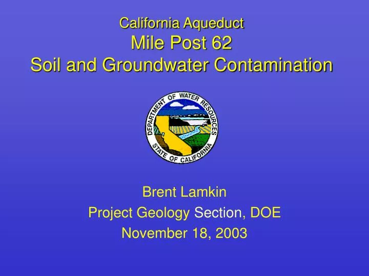
California Aqueduct Mile Post 62 Soil and Groundwater Contamination. Brent Lamkin Project Geology Section , DOE November 18, 2003. Introduction. Issue – Soil and groundwater contamination within DWR right-of-way, adjacent to the California Aqueduct Scope Monitor contamination

E N D
California AqueductMile Post 62Soil and Groundwater Contamination Brent Lamkin Project Geology Section, DOE November 18, 2003
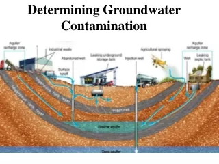
Introduction • Issue – Soil and groundwater contamination within DWR right-of-way, adjacent to the California Aqueduct • Scope • Monitor contamination • Provide technical support to SLFD • Protect and represent DWR interests in dealing with regulatory agencies and pipeline owner
Introduction (Cont.) • Location • Northwest Merced County • Approximately 4.5 miles upstream of O’Neill Forebay • Aqueduct Features • Constructed August 1964 – January 1968 • 32.6’ deep, 1.5:1 slopes, 40’ base width • 10,000 cfs capacity
Geologic Setting • Aqueduct Reach Constructed in: • Cretaceous shales, sandstones, & siltstones of the Moreno and Panoche formations • Tertiary shales, sandstones, siltstones, and claystones of the Tesla, Kreyenhagan, & Neroly formations • Quaternary alluvium, terrace deposits, and fill
Site Geology Moreno Formation • During construction mapped as weak shale interbedded with sandstone • Subject to air and water slaking & local bedding plane failures • Bedding dips SE into the Aqueduct excavation • Upper Moreno Slide Correction • 9,300’ upstream & downstream • Overexcavation and backfill 30’ behind right cut-slope and 7’ below invert
Site Geology (Cont.) • Quaternary Older Terrace Deposits • Poorly Graded Sand to Silty Sand and Lean Clays dipping 1-2 degrees SE • Quaternary Alluvium • Lean to Fat Clay with Sand topsoil • Fill - Compacted GC, SC, GM, SM, CL • Spoil – Silt and Silty Sand excavation material
1984 Petroleum Release • 16” Crude Oil Pipeline Rupture • 1,000 – 4,000 barrels released • Crude oil mixed with petroleum distillate • Located approx. 200 feet SW of Aqueduct • and 100’ downstream of pipeline crossing • Pipeline repair included excavation of contaminated soil around leak (150’x15’)
Site Investigation 1984-2001 • Soil Borings and Monitoring Wells • 26 Soil borings by Unocal (1984), all with PVC screen installed • 2 Monitoring and 2 extraction wells installed by OHM (1985) • 16 Monitoring and 12 extraction wells installed by B & C (1986-1991) • 5 Monitoring wells & extraction trench installed by PEG (1998)
Historic Groundwater Max. Contaminant Concentrations • Benzene – 390 mg/l (MW-11, Aug. 2001) • Purgable Pet. Hydrocarbons (C6-C12) – 1,100 mg/l (2E, May 1989) • Extractable Pet. Hydrocarbons (C9-C24) – 22 mg/l (1B, Aug. 2000) • Extractable Pet Hydrocarbons (C9-C36) – 49 mg/l (BC-4, Feb. 2001) • Up to 18’ of free product measured above groundwater surface
1997 Landslide & Liner Failure • Landslide • Approx. 120’ wide x 45’ high • Encroached 35’ into right side of canal • Occurred within untreated Moreno Fm. shale • Result of rapid dewatering to address MP 55 seepage of 800-1,000 gpm • Liner Failure • Exposed Aqueduct water to soil and groundwater contaminants • Reduced cross-sectional area of canal prism, and flow capacity, by approx. 10-15%
Contamination Released as a Result of the1997 Landslide • Surface Water in Aqueduct • 65 mg/l TPPH • 2,500 mg/l TEPH (C9-C24) • 3,900 mg/l TEPH (C9-C40) • 2.3 mg/l total xylenes • Excavated Soil • 360 mg/kg TEPH (C9-C40) • 98 mg/kg total xylenes • 26 mg/kg ethylbenzene
Recent Site Investigation 2001-2003 • Four monitoring wells installed by TRC • Aquifer testing to evaluate pump and treat remediation system (extraction trench) • Bioremediation studies and monitoring of electron receptors, metabolic by-products, and oxidation reduction potential • Passive contaminant extraction • Continued groundwater, surface water, and dewatering sump sampling and monitoring • DWR data analysis for contaminant trends
Recent Groundwater Max. Contaminant Concentrations • Benzene – 360 mg/l (MW-11, Aug. 2001) • Purgable Pet. Hydrocarbons (C6-C12) – 2,800 mg/l (MW-1, Aug. 2001) • Extractable Pet. Hydrocarbons (C9-C24) – 9,700 mg/l (BC-4, Feb. 2002) • Extractable Pet. Hydrocarbons (C9-C36) – 14,000 mg/l (BC-4, May 2002) • Others – Other VOCs, SVOCs, & Furans – ND • Max. thickness of free product is 0.02’
Recent Groundwater Contaminant Trends • Benzene • Areal Extent – Extensive, concentrated near release • Frequency of Detection – Most often in the spring • Concentrations – Average 27.5 mg/l, highest avg. in summer, 77% reduction between 01/02 and 02/03 • TRPH (Gasoline Range Hydrocarbons) • Areal Extent – Extensive, concentrated near release • Frequency of Detection – Most often in the summer • Concentrations – Average 426 mg/l, highest avg. in summer, 71-78% decrease between 01/02 and 02/03
Recent Groundwater Contaminant Trends (Cont.) • TEPH (Diesel Range Hydrocarbons) • Areal Extent – Extensive, concentrated near release and at Sump 62.39 • Frequency of detection – Most often in summer and winter • Concentrations – Average 1,451 mg/l, highest average in spring, reduction of 13% from 01/02 - 02/03 • TEPH (Crude Oil Range Hydrocarbons) • Areal Extent – Extensive, concentrated near release • Frequency of Detection – Most often in spring and summer • Concentrations – Average 2,096 mg/l, highest average in spring, increase of 68% from 01/02 - 02/03
Future Characterization and Remediation Activities • Define eastward limits of plume • Characterize soil and groundwater contamination at landslide for repair • Complete bioremediation feasibility study and implement remediation • Conduct removal of contaminated soil adjacent to landslide as part of Aqueduct liner repair • Continued monitoring