Download
1 / 10
120 likes | 284 Views
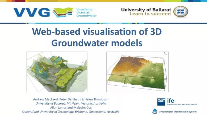
Web-based visualisation of 3D Groundwater models. Andrew MacLeod, Peter Dahlhaus & Helen Thompson University of Ballarat, Mt Helen, Victoria, Australia Allan James and Malcolm Cox Queensland University of Technology, Brisbane, Queensland, Australia. Background.

E N D
Web-based visualisation of 3D Groundwater models Andrew MacLeod, Peter Dahlhaus & Helen Thompson University of Ballarat, Mt Helen, Victoria, Australia Allan James and Malcolm Cox Queensland University of Technology, Brisbane, Queensland, Australia
Background VVG is an interoperable web-GIS that federates groundwater data from disparate sources to assist water managers make the correct choices for the sustainable use of a precious resource www.vvg.org.au
Web-based 3D visualisation • Traditional methods • VRML and X3D • Generally require a browser plugin • Natural Resources Canada – Groundwater Information Network (GIN) • Recent advancements • HTML5 and WebGL • Makes use of graphic processing capability of the viewing device • Once loaded, interactivity is excellent
The solution: a marriage • Groundwater Visualisation System (GVS) • Powerful, desktop based system • Based on open source technology • Visualising Victoria’s Groundwater (VVG) • Intuitive, web-based delivery system • Based on open source technology • The marriage • Web-based access via 2D map (VVG) • Rendering occurs on a remote server (GVS) • Image stream delivered from server to browser • HTML5 web sockets to provide real-time interactivity • Low latency, full duplex communication • No processing requirement on the end user device
What’s next • Scalability and speed • Number of simultaneous users • Size and complexity of models • Number of dynamically loaded features • Loading features and surfaces via web service (WMS, WFS, WCS, TMS) • Exposing more functionality • Water level animations • Hydrographs • 2D cross sections • Modelling on-the-fly • Improving the data
Thankyou • Primary funding supplied by the State Government of Victoria • Broadband Enabled Innovation Program (BEIP)