Download
1 / 66
660 likes | 755 Views
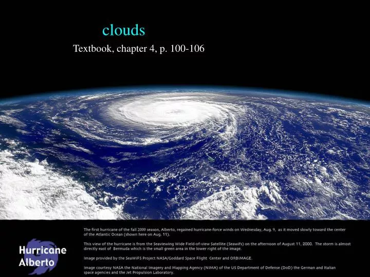
clouds. Textbook, chapter 4, p. 100-106. Cloud classification. Originally by Luke Howard (1850’s) Currently used nomeclature based on Abercromy & Hildebrandsson (1887) Linnean system (genus, species) morphological only, not genealogical

E N D
clouds Textbook, chapter 4, p. 100-106
Cloud classification • Originally by Luke Howard (1850’s) • Currently used nomeclature based on Abercromy & Hildebrandsson (1887) • Linnean system (genus, species) • morphological only, not genealogical • Latin Root Translation Example • cumulus heap fair weather cumulus • stratus layer altostratus • cirrus curl of hair cirrus • nimbus rain cumulonimbus
Cloud subclassification Further classification identifies clouds by height of cloud base. 3 levels Examples: the prefix "cirr-" (as in cirrus clouds) refers to high levels, the prefix "alto-" (as in altostratus) refers to middle levels.
Relative heights vary zonally H M L H M L H M L tropopause Tropics Midlatitudes Poles
High clouds composed of ice crystals fibrous or filamentous shape ice crystal concentration generally very small
Cirrus uncinus (mares’ tails) Height (km): 7-10 km+ Falling light snow [fallstreaks], not reaching the ground. distorted by upper-tropospheric wind shear.
Cirrus Cirrus uncinus Cirrus floccus Cirrus fibratus vertibratus Cirrus uncinus
Cirrus Cirrus uncinus Cirrus spissatus Cirrus spissatus with virga
Cirrostratus continuous sun shines thru, no precipitation process: widespread ascent aloft, or old thunderstorm anvil halo
Cs broken into waves sun shine thru, no precipitation process: widespread ascent combined with convective overturning in a thin layer. Cirrocumulus
Middle clouds * occur at altitudes where temperatures range between 0 and -25ºC (32 and -13ºF). * composed of supercooled water droplets, or are in mixed-phase (supercooled water droplets and ice crystals). Altostratus clouds occur as uniformly gray or white layers that totally or partially cover the sky. They are usually so thick that the sun is only dimly visible, as if viewed through frosted glass.
Altostratus Height (km): base=2-6 km, can be thick, liquid or ice, no precipitation reaching the ground. Process: widespread stable ascent, often preceding a surface warm front. Altostratus has a uniform and diffuse coverage
Altocumulus base=2-6 km, usually thin, usually liquid, no precipitation. Process: widespread ascent combined with convective overturning aloft (left) or with wave activity (right) clear regions descending air cloudy regions ascending air
Altocumulus Sharp cloud boundaries indicate the presence of water droplets rather than ice crystals. Altocumulus castellanus Altocumulus stratiformis
Low-Level Clouds * usually at temperatures above -5ºC (23ºF) * composed mostly of water droplets. geostationary satellite precipitation
Stratus Base>0.1 km, top<3 km, liquid (or ice), may have drizzle falling. Process: stable ascent, mixing Fog occurs when stratus meets the ground; when it lifts, it may break up into stratocumulus.
Nimbostratus steady light precipitation
Stratocumulus Shallow, usually liquid, no precipitation Process: forced or spontaneous overturning in a shallow layer
cumulus Buoyantly rising air parcels (thermals) become saturated Cu cloud base … LCL Shallow or deep Cumulonimbus Cu mediocris Cu humulis LCL
Fair-Weather Cumulus Widely separated heap clouds of small vertical development. With flat bottoms and rounded tops, they resemble a flock of sheep grazing in a pasture.
Cumulus congestus Larger and deeper cauliflower appearances to the tops. Base is flattish, representing the LCL. Can produce showers. Cloud top=5-7 km, above the freezing level but usually still liquid.
Cumulonimbus Look at this animation
Cumulonimbus: the most active member of the cumulus family Convective family over the South China Sea
A: cirrus B: cirrostratus C: cirrocumulus D: altostratus E: altocumulus F: stratus G: stratocumulus H: cumulus humilis I: cumulus congestus J: cumulonimbus J: nimbostratus Pop quizzes: cloud identification
cirrus • cirrostratus • cirrocumulus • altostratus • altocumulus • stratus • stratocumulus • cumulus humilis • cumulus congestus • cumulonimbus • nimbostratus a mid-level cloud in the lee of mountain ranges
cirrus • cirrostratus • cirrocumulus • altostratus • altocumulus • stratus • stratocumulus • cumulus humilis • cumulus congestus • cumulonimbus • nimbostratus
cirrus • cirrostratus • cirrocumulus • altostratus • altocumulus • stratus • stratocumulus • cumulus humilis • cumulus congestus • cumulonimbus • nimbostratus
Hint: it is overcast, but not raining • cirrus • cirrostratus • cirrocumulus • altostratus • altocumulus • stratus • stratocumulus • cumulus humilis • cumulus congestus • cumulonimbus • nimbostratus
cirrus • cirrostratus • cirrocumulus • altostratus • altocumulus • stratus • stratocumulus • cumulus humilis • cumulus congestus • cumulonimbus • nimbostratus
cirrus • cirrostratus • cirrocumulus • altostratus • altocumulus • stratus • stratocumulus • cumulus humilis • cumulus congestus • cumulonimbus • nimbostratus
Hint: this cloud layer is low • cirrus • cirrostratus • cirrocumulus • altostratus • altocumulus • stratus • stratocumulus • cumulus humilis • cumulus congestus • cumulonimbus • nimbostratus
Hint: this cloud layer is high • cirrus • cirrostratus • cirrocumulus • altostratus • altocumulus • stratus • stratocumulus • cumulus humilis • cumulus congestus • cumulonimbus • nimbostratus
cirrus • cirrostratus • cirrocumulus • altostratus • altocumulus • stratus • stratocumulus • cumulus humilis • cumulus congestus • cumulonimbus • nimbostratus this is a halo
Hint: it is raining • cirrus • cirrostratus • cirrocumulus • altostratus • altocumulus • stratus • stratocumulus • cumulus humilis • cumulus congestus • cumulonimbus • nimbostratus
A few other cloud visual clues1. anvil development view this animation process: buoyant ascent lightning usual (lightning is rare over the oceans) much precip evaporates if LCL is high
Cumulonimbus: Severe weather lightning, thunder, heavy rains, hail, strong winds, and tornadoes … Model simulations: Typical thunderstorm Severe thunderstorm
Cumulonimbus: Shelf clouds We are just ahead of a severe thunderstorm. Dewpoints are in the mid-70s. Winds gust to over 40 mph with the passage of this shelf cloud. Evaporatively cooled air is pushed out of the precipitation area by the downdraft, warm air slides up and over the gust front forming the concave-shaped shelf cloud.
Cumulonimbus: Mammatus clouds pockets of negatively-buoyant air, filled with snow suspended from the anvil base
Mesoscale Convective Complexes Radar animation
Orographic and wave clouds Orographic clouds are produced by the flow of air interacting with mountainous terrain. They often indicate areas of clear air turbulence. lee wave mountain wave