Download
1 / 8
80 likes | 265 Views
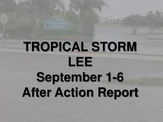
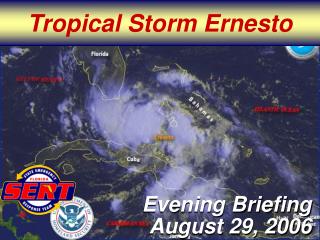
Update on Tropical Storm Lee. 3:30 pm – September 3, 2011. Key Points. Tropical Storm Lee has strengthened over the last 24 hours, and is now a strong tropical storm with maximum sustained winds of 60 mph over water east of the center.

E N D
Update on Tropical Storm Lee 3:30 pm – September 3, 2011
Key Points • Tropical Storm Lee has strengthened over the last 24 hours, and is now a strong tropical storm with maximum sustained winds of 60 mph over water east of the center. • The system is embedded in weak steering currents, and will move slowly and erratically toward the N and NE later this weekend. • On the track, widespread very heavy rainfall of 6-12” (locally heavier in spots) will be the major threat. • Gusty winds (a few gusts of 40-45 mph possible) will also cause some issues, with a few power outages possible. • Risk for a few tornadoes looks like it may be greater than initially expected, particularly along/SE of the Natchez Trace.
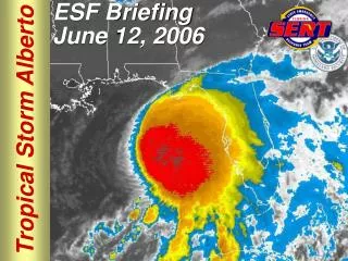
NHC Forecast • Currently just SW of Atchafalaya Bay, LA • Max sustained winds 60 mph (mainly over water E/SE of center) • Movement is nearly stationary • Minimum central pressure: 989 mb
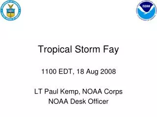
Recap • TS Lee will move slowly NE over the next few days, and continue to impact the Arklamiss through at least Monday night • Threats (primarily along and SE of a Delhi, LA to Columbus line): • Rainfall of 6-12” with locally heavier amounts • Some river and flash flooding possible • Winds gusting to 30-45 mph at times • A few trees/limbs down with some power issues • Isolated tornadoes