Download
1 / 27
270 likes | 275 Views
The Visible Infrared Imaging Radiometer Suite (VIIRS) on the Suomi NPP satellite offers unique characteristics for polar winds tracking, including higher spatial resolution, wider swath, and a day-night band. This article discusses the advantages of VIIRS over MODIS for polar winds product, with a focus on improved resolution at the edge of the swath.

E N D
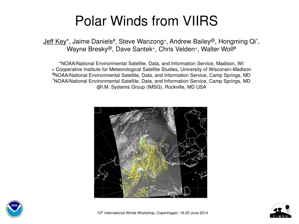
Polar Winds from VIIRS Jeff Key*, Jaime Daniels#, Steve Wanzong+, Andrew Bailey@, Hongming Qi^, Wayne Bresky@, Dave Santek+, Chris Velden+, Walter Wolf# *NOAA/National Environmental Satellite, Data, and Information Service, Madison, WI + Cooperative Institute for Meteorological Satellite Studies, University of Wisconsin-Madison #NOAA/National Environmental Satellite, Data, and Information Service, Camp Springs, MD ^NOAA/National Environmental Satellite, Data, and Information Service, Camp Springs, MD @I.M. Systems Group (IMSG), Rockville, MD USA 12thInternational Winds Workshop, Copenhagen, 16-20 June 2014
Unique Characteristics of VIIRS • The Visible Infrared Imaging Radiometer Suite (VIIRS) on the Suomi National Polar-orbiting Partnership (S-NPP) satellite was launched 28 October 2011. • VIIRS will be on the JPSS series of satellites, replacing AVHRR as NOAA’s operational polar-orbiting imager. • VIIRS’ unique characteristics relevant to a polar winds product include: • Higher spatial resolution (750 m for most bands; 375 m for some) • Wider swath than MODIS • Constrained pixel growth: better resolution at edge of swath • Day-night band (DNB) • Disadvantage: No thermal water vapor band so no clear-sky WV winds • The VIIRS polar winds processing utilizes the GOES-R AMV algorithm.
VIIRS Coverage: Wider Swath VIIRS has a wider swath (3000 km) than MODIS (2320 km), so the coverage will be better and will extend further south. VIIRS MODIS A wider swath means more winds with each orbit.
Improved Resolution at Edge of Swath • VIIRS method of aggregating detectors and deleting portions of the scans near the swath edge results in smaller pixels at large scan angles. • For thermal bands, VIIRS is 0.56 km2 (0.75 x 0.75 km) at nadir and 2.25 km2at the edge of the swath (0.37 -> 0.8 km for imager bands; 0.74 -> 0.74 km for DNB) • In contrast, AVHRR and MODIS are 1 km2 at nadir and 9.7 km2at edge of swath. • Additionally, VIIRS scan processing reduces the bow-tie effect.
Effects of Scan Angle on Winds Does the improved resolution away from nadir matter for wind retrieval? Good MODIS Winds (QI > 0.6) Not-so-good MODIS Winds (QI < 0.6) Nadir Nadir So it is clear that many of the winds toward the swath edges are filtered out by QC.
VIIRS Day-Night Band (DNB) • Satellite-based low light detection was pioneered by the Operational Linescan System (OLS), which has flown continuously on the Defense Meteorological Satellite Program (DMSP) since 1967. • VIIRS has a “Day/Night Band” (DNB), which offers marked advances over the heritage DMSP/OLS. • We are not yet using this band for AMVs. DMSP F-16 1/12/2011 0516UTC Aurora Borealis Sea Ice Barrow Open Water Channels (Courtesy of Steve Miller, CIRA)
GOES-R ABI and VIIRS Algorithm Unique features of the ABI wind retrieval methodology: Feature Tracking: The Sum-of-Squared Differences (SS) method is used in conjunction with the “nested tracking” algorithm that is very effective at capturing the dominant motion in each target scene being tracked to track the feature backward and forward in time. Target Height Assignment: Externally-generated cloud heightsare used. This approach offers the best opportunity to assign the most representative heights to targets being tracked in time and contains diagnostic performance metrics.
Clouds Heights: Externally-Generated vs Windco • Windco quality control eliminates many of the cases where heights are significantly different, but biases remain: Thin Clouds, QI > 0.6 Thick Clouds, QI > 0.6
Orbits VIIRS provides similar time coverage as Aqua, NOAA-19, and NOAA-18. Animation of Terra, Aqua, NPP and others (not NOAA-xx) at https://www.youtube.com/watch?v=WT-WhWHPyk4.
VIIRS Polar Winds Status • The VIIRS polar winds product became operational in NESDIS on 8 May 2014. • Many changes to the processing have been made, including the conversion of VIIRS data to a polar stereographic projection, conversion to AREA files, and integration into GEOCAT, all without McIDAS. • This is the first GOES-R algorithm to become operational.
Validation: Radiosondes September, 2013 – January, 2014 Requirements: Statistics are similar for comparisons with aircraft winds.
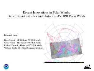
Direct Broadcast VIIRS Polar Winds • DB winds generated at Fairbanks, Alaska (the only site so far). • Uses the heritage algorithm (“windco”), not nested tracking. NESDIS ops DB Graphical comparison of DB (left) and operational (right) VIIRS winds
Direct Broadcast VIIRS Polar Winds Graphical comparison of DB (cyan) and operational (yellow) VIIRS winds together. DB (cyan) NESDIS ops (yellow) DB (cyan) NESDIS ops (yellow)
Latency • The time it takes to generate winds after the time of the last image in an orbit triplet is, on average, approximately 0.8 hrs for DB winds and 2.0-2.5 hrs for the operational winds. • 100 minutes (1.7 hrs) must be added to these numbers to obtain the actual latency of the wind observation because its time is that of the middle image/orbit.
All Polar Winds Products: History 10-day MODIS winds case study made available Real-time AVHRR winds MODIS DB winds at Fairbanks LEO-GEO winds MODIS DB winds at McMurdo Mixed-satellite MODIS winds VIIRS DB winds at Fairbanks Real-time Terra and Aqua MODIS winds AVHRR historical winds (v2) Metop AVHRR winds 2011 2012 2001 2002 2003 2004 2014 2010 2015 2009 2005 2006 2007 2008 2013 Daily AVHRR winds AVHRR HRPT winds from Rothera NESDIS MODIS winds on GTS MODIS DB winds at Tromsø VIIRS winds MODIS DB winds at Sodankylä ECMWF and NASA DAO demonstrate positive impact MODIS, AVHRR winds with nested tracking algorithm AVHRR HRPT winds from Barrow DB winds distributed via EUMETCast Terra MODIS winds in ECMWF operational system
The Polar Wind Product Suite LEO-GEO • Combination of may geostationary and polar-orbiting imagers • Fills the 60-70 degree latitude gap EW VIIRS • S-NPP (GOES-R algorithm) • Direct broadcast at Fairbanks (heritage algorithm) Notes: • NOAA-17 was decommissioned on 10 April 2013. AVHRR unusable since March 2010. • NOAA-16 was decommissioned on 9 June 2014. Operational MODIS • Aqua and Terra separately • Aqua and Terra combined • Direct broadcast (DB) at • McMurdo, Antarctica (Terra, Aqua) • Tromsø, Norway (Terra) • Sodankylä, Finland (Terra) • Fairbanks, Alaska (MODISdiscontinued) EW AVHRR • Global Area Coverage (GAC) for NOAA-15, -16, -17, -18, -19 • Metop-A, -B • HRPT (High Resolution Picture Transmission = direct readout) at • Barrow, Alaska, NOAA-18, -19 • Rothera, Antarctica, NOAA-18, -19 • Historical GAC winds, 1982-2012. Two satellites throughout most of the time series. Operational Operational Operational
European Centre for Medium-Range Weather Forecasts (ECMWF) - since Jan 2003. • NASA Global Modeling and Assimilation Office (GMAO) - since early 2003. • DeutscherWetterdienst (DWD) – MODIS since Nov 2003. DB and AVHRR. • Japan Meteorological Agency (JMA), Arctic only - since May 2004. • Canadian Meteorological Centre (CMC) – since Sep 2004. DB winds since Mar 2009. • US Navy, Naval Research Lab, Fleet Numerical Meteorology and Oceanography Center (FNMOC) –since Oct 2004. DB winds since Apr 2006. AVHRR GAC, Metop since Nov 2007. • Met Office – MODIS since Feb 2005. DB since Feb 2009. AVHRR GAC since May 2008. • National Centers for Environmental Prediction (NCEP) and the Joint Center for Satellite Data Assimilation - since Nov 2005. • Météo-France - since Jun 2006. • National Center for Atmospheric Research (NCAR), Antarctic Mesoscale Model (AMPS) - since Oct 2006. • Australian Bureau of Meteorology – since late 2007 • China Meteorological Administration (CMA) – since mid-2009 • HydroMeteorological Center of Russia (Hydrometcenter) – since 2010 Operational NWP Users of Polar Winds 13 NWP centers in 9 countries:
Respondents: • European Centre for Medium-Range Weather Forecasts (ECMWF) • NASA Global Modeling and Assimilation Office (GMAO) • DeutscherWetterdienst (DWD) • Japan Meteorological Agency (JMA) • Meteorological Services of Canada (MSC) • Naval Research Lab/FNMOC (two survey entries) • Met Office • National Centers for Environmental Prediction (NCEP) and the Joint Center for Satellite Data Assimilation • Météo-France • HydroMeteorological Center of Russia (Hydrometcenter) – since 2010 Polar Winds User Survey (May 2014)
Survey Comments: 1) MODIS AMVs are in operations, AVHRR are under investigation (work by D.Santek) and soon to be added to ops, VIIRS are currently being added to the BUFR data stream. 3) Ascii and NETCDF formats are fine for research purposes only 5) MODIS WV winds are about 90% in terms of counts of the all number of MODIS winds (WV+CloudDrift) Currently, we are using data in ASCII. Transition to BUFR will be needed soon for operational reasons. To accomplish this transition, we will need a BUFR reader and a period of parallel ASCII and BUFR data transmission. Thanks for your data, we like them! AVHRR winds and VIIRS winds of Q4 is not used in the JMA operational NWP system. JMA has a plan for use these winds. In our operational run we use polar winds that are used in NCEP, since we share and get data that are used in their GFS/GDAS run. We are using extra AVHRR polar winds for our next reanalysis (MERRA2). Thanks for your work pioneering these products. Polar winds will become increasingly vital as commercial and DOD entities ramp up their operations within this domain as sea ice retreat provides new opportunities. We are currently monitoring the direct broadcast MODIS winds but do not assimilate them.
Summary • Several unique characteristics of VIIRS are expected to influence the quality of the polar winds product: wider swath, higher spatial resolution across the swath. We have not expoited the day-night band (DNB) yet. • VIIRS polar winds became operational in May 2014. It uses theGOES-R AMV algorithm. • Validation statistics are good, being similar to MODIS winds. • Direct broadcast VIIRS winds are generated on-site at Fairbanks, Alaska. • The recent survey indicates that all polar winds products are utilized in NWP operations, though not all are used by every center. • Future work: MODIS and (maybe) AVHRR products will be converted to the nested-tracking (GOES-R) algorithm.