Download
1 / 1
10 likes | 107 Views
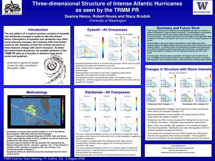
Three-dimensional Structure of Intense Atlantic Hurricanes as seen by the TRMM PR. Summary and Future Work. Eyewall—All Overpasses. Introduction. Schematic of typical rain pattern as seen by radar, according to Willoughby (1988). Outer eyewall. eye. Inner eyewall. Principle band.

E N D
Three-dimensional Structure of Intense Atlantic Hurricanes as seen by the TRMM PR Summary and Future Work Eyewall—All Overpasses Introduction Schematic of typical rain pattern as seen by radar, according to Willoughby (1988) Outer eyewall eye Inner eyewall Principle band Changes in Structure with Storm Intensity Secondary bands Rainbands—All Overpasses Methodology Acknowledgements TRMM and PMM Grant NAG5-13654 and NNX07AD59G NASA ESS Grant NNX06AF17H RAINEX National Science Foundation Grant ATM-0432623 Deanna Hence, Robert Houze and Stacy BrodzikUniversity of Washington CFAD analysis illustrates the differences in precipitation structure as a function of radius and quadrant in intense Atlantic hurricanes. The precipitation in the eyewall annulus was mostly uniform and intense, with evidence of occasional deep convective towers. The eyewall overall tends to be stronger on the right side, likely a response to stronger convergence, but is even more so in stronger (Category 4-5) storms. The precipitation was more shallow and stratiform in the middle radii (inner rainband region) and slightly deeper and more convective at the farthest radii (outer rainband region). In stronger storms, the rainbands are weakest and least present in the left-front quadrant, preferring the right side of the storm. In weaker storms, the left-rear quadrant is weakest, with the rainbands preferring the front of the storm. For future work, the study will be expanded to all tropical cyclone basins for all years of TRMM mission (1998-present) to study variability in structure associated with changes in storm intensity, location, and environment including shear and SST. The rain pattern of a tropical cyclone consists of eyewalls and rainbands arranged in patterns like that shown below. Interactions of eyewalls and rainbands may affect storm intensity changes, but relatively little information exists on the statistics of how the vertical structure of these features change with storm evolution. To better document these structures, we compile statistics of the TRMM PR data as a function of distance from storm center and quadrant.. Annulus 1 by Quadrant Annulus 1 Quad 4 Quad 1 Storm motion Quad 2 Quad 3 • Eyewall precipitation intense at all levels with generally uniform structure (tight gradients) associated with slantwise convection. • Deep, intense outliers suggest some deep convective towers within the eyewall region. • Right quadrants most intense at all levels, suggesting large particle generation associated with stronger convergence. • Left quadrants weaker, associated with weaker convergence and/or divergence. Left front suggests large particle advection at low levels. Left rear quadrant the weakest. Annulus 1 by Quadrant Quad 4 Quad 1 Quad 4 Quad 1 Storm motion Storm motion Quad 2 Quad 3 Quad 2 Quad 3 TRMM PR Reflectivity at 03:36 on 28 August 2005 dBZ Annulus 2 Annulus 3 Annulus 4 51 4 45 39 Storm motion 3 33 Overpasses when Category 1-2 Overpasses when Category 4-5 27 21 15 • Eyewall precipitation is deeper, more intense and uniform at all levels when storms are stronger (Category 4-5). • Eyewall precipitation is more variable, less deep and less intense when storms are weaker (Category 1-2). • Rainbands vary little in structure above the melting level as a function of intensity (not shown). Variability expressed below melting level. • When storms are stronger, right quadrants in the eyewall are deeper than the left quadrants. Rainbands favor right-front quadrant, left front quadrant weakest and least occurrence. • Front quadrants of eyewall are more uniform below the melting level than the rear quadrants when storms are weaker. Front quadrants favored for rainbands, left rear quadrant weakest and least occurrence. 1 9 2 3 Annulus 5 Annulus 6 Annulus 7 • Overpasses of storms that reached Category 4 or 5 in the Atlantic Basin between 1998-2007 while hurricane strength. • Contour Frequency by Altitude Diagrams (CFADS, Yuter and Houze (1995) ) generated by radius annulus, quadrant, as well as radius and quadrant for each storm overpass. • Annulus rings are based on the eye diameter (Re) reported by the National Hurricane Center: Annulus 1 (green) = Re+ 17 km, Annulus 2 (yellow) is 2R1, Annulus 3 (orange) is 3R1, etc. Annulus 10 is everything outside of Radius 9. • Quadrants (white) are determined counter-clockwise from the storm motion vector. • The inner rainband precipitation (Annuli 2-4) decreases in height with radius, are highly uniform above the melting level with a sharp brightband, suggesting stratiform precipitation. • The increase in variability below the melting level with radius without corresponding variability above suggests the increasing presence of convection with radius. • The outer rainband precipitation (Annuli 5-7) increase slightly in height with radius, decrease in uniformity above and below the melting level as well as intensity below the melting level. • Annuli 8-9 vary little from Annulus 10 (environmental tropical convection) PMM Science Team Meeting, Ft. Collins, CO, 5 August 2008