Download
1 / 4
70 likes | 407 Views
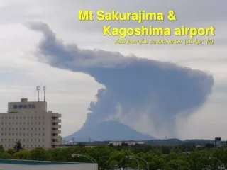
Sakurajima. Ing Team 3. Location. Longitude: 130.657°E 130°39'25"E Latitude: 31.585°N 31°35'6“N Located in Kyushu (Japan ) northern half of Kagoshima Bay. Properties of the Lava. The lava is andesite and content of SiO 2 is 57-66% Maximum range of flight of volcanic bombs: 3 km

E N D
Sakurajima Ing Team 3
Location • Longitude: 130.657°E 130°39'25"E • Latitude: 31.585°N 31°35'6“N • Located in Kyushu (Japan) northern half of Kagoshima Bay
Properties of the Lava • The lava is andesite and content of SiO2 is 57-66% • Maximum range of flight of volcanic bombs: 3 km • Maximum flow length of pyroclastic flows: 1.2 km
Historic Background • More than 7,300 explosive eruptions have been recorded in the past 45 years. • Largest eruptions took place in 1471-1476, 1779-1782, 1914. (During the 1914 eruption the pyroclastic flow connected the island to the mainland.)