Download
1 / 18
180 likes | 332 Views
WIPP Far-Field Hydrology. Kristopher L. Kuhlman 4 th US/German Workshop on Salt Repository Research, Design and Operations Berlin, Germany September 2013.

E N D
WIPP Far-Field Hydrology Kristopher L. Kuhlman 4th US/German Workshop on Salt Repository Research, Design and Operations Berlin, Germany September 2013 Sandia National Laboratories is a multi-program laboratory managed and operated by Sandia Corporation, a wholly owned subsidiary of Lockheed Martin Corporation, for the U.S. Department of Energy’s National Nuclear Security Administration under contract DE-AC04-94AL85000. SAND NO. 2013-7622C
Waste Isolation Pilot Plant (WIPP) WIPP site 4 × 4 mile square (6.5 km on a side) Google Maps image Transuranic (TRU) waste permanent underground geologic repository
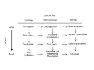
WIPP Hydrogeology • Repository in Salado Permian bedded salt • >500-m thick salt unit • Immeasurably low undisturbed permeability from surface • Human Intrusion required for repository breach • High-pressure Castile brine • Culebra Member Rustler Frm. • Most permeable unit • Laterally extensive • ~7.5-m thick dolomite • Fractured (dual-porosity) • Focus of hydrologic testing
Culebra Conceptual Model East West (Nash Draw) • Two types of processes control Culebra transmissivity (T) • Depositional • Lateral deposition of sediments or evaporites (mudstone/halite facies) • Alteration • Fracturing • Salado dissolution • Fracture in-filling • High T in West • WIPP-26 : -2.9 log10(T) m2/s • Low T in east • SNL-15 : -12.9 log10(T) m2/s
Single-Well Hydraulic Tests 30 km • >90 tested Culebra locations • Doesn’t include slug or drill-stem tests • Single-well tests show 10 orders of magnitude variation in T
Multi-Well Hydraulic/Tracer Tests ~30 m ~30 m ~30 m • 20 pad-scale pumping tests • 10 pads / 20 tests / 36 wells • 8 multi-well tracer tests • Convergent/Dipole/Single-Well Injection-Withdrawal • H-19: drilled 7 wells for tracer test in 1990s
Multi-Pad Hydraulic Tests • 17 multi-pad pumping tests • Up to13 observation wells/test • Observations up to 11 km away • 73 pump/observation pairs • Q up to 2.6 L/s (42 gpm) • Up to 63 days of pumping • Diffusivity (D=T/storativity) used to characterize multi-well response • Close match to single-well fractured/un-fractured distinction
Large-Scale Natural Stimuli “Tests” • Growing database of high-frequency observations. • Natural stimuli have large-scale effects • Precipitation • Barometric pressure • Earth-tides • Oil/gas/potash drilling • Mine collapses • “Free” testing stimuli • Poor source characterization • Hard to untangle multiple effects IMC-461 (in Nash Draw) pressure response and rainfall
Oil/Gas/Potash Drilling • Not natural stimuli, uncontrolled and ubiquitous • Discrete location/time affects smaller area (< 5km) • Questionable info available regarding “spud” dates • Simulation? • 2D groundwater flow due to pulse source
Potash Mine Subsidence • March 2012 large mine collapse (unoccupied) • ~1.5 km of roof fell • 3.0 magnitude event reported by USGS • 2 Culebra wells near collapse showed significant shifts in water level • Oscillatory response is not purely hydraulic • Model a geomechanical response?
Barometric Pressure & Earth-Tides • Previously removed to analyze pumping test data • Statistical approach (moving average least-squares fit) • Alternately, use physical model to explain effects • Estimate: • aquifer T, S, and porosity • vadose zone air permeability • Source is well defined • Simulation? • 1D vertical pressure wave • Solid stress/strain relation A: Original data B&C: Barometric only D: Barometric + Earth tide
Precipitation • Most rain in a few major storms in Chihuahua Desert • Shallow system dries out between rain events • Source poorly characterized spatially • Karst plumbing in Nash Draw is complex • Complex geology • Difficult to simulate hydrology • Simulation? • Include precipas source term in 2D model
Culebra in WIPP PA • Created 1000 random base realizations (GSLIB) • Large-scale pumping tests • Culebra gypsum content • Fracture presence • Overburden thickness • Calibrated 100 realizations to observed data • Pumping tests • Freshwater head piezometric surface • Ensemble prediction for solute transport in PA
Summary • Culebra Characterization historically focused on well testing • New focus on “data mining” existing and future high-frequency monitoring records • Use modeling to bring multiple scales of data together
Conclusions • SNL testing Culebra at a range of scales @ WIPP • Working to incorporate all data in site PA flow model • Methodologies applicable to other sites • Far-field hydrology is always very visible to stakeholders and regulators