Download
1 / 50
500 likes | 507 Views
Learn about the layers of the Earth and how to identify different types of rocks with this informative guide. Explore erosion, deposition, and the effects of physical processes on geological features.

E N D
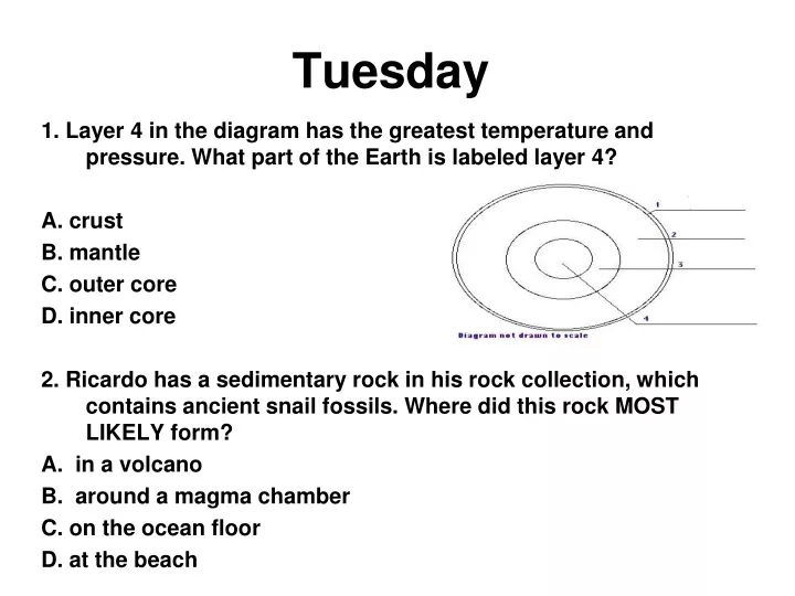
Tuesday 1. Layer 4 in the diagram has the greatest temperature and pressure. What part of the Earth is labeled layer 4? A. crust B. mantle C. outer core D. inner core 2. Ricardo has a sedimentary rock in his rock collection, which contains ancient snail fossils. Where did this rock MOST LIKELY form? A. in a volcano B. around a magma chamber C. on the ocean floor D. at the beach
Tuesday 3. Students want to identify a rock in a nearby field. Which of the following properties would be most useful in identifying the unknown rock? A. Luster B. Smell C. Mineral Content D. Specific Weight 4. Igneous rock forms from A. compaction and cementation of sediments. B. weathering and erosion of other rocks. C. magma deep within the Earth. D. evaporation of water from a pond.
Erosion & Deposition: Standard: S6E5: Students will investigate the scientific view of how the earth's surface is formed.Element: d.Describe processes that change rocks and the surface of the earth. e. Explain the effects of physical processes (plate tectonics, erosion, deposition, volcanic eruption, gravity) on geological features.
Essential Questions: • What is erosion? • What causes erosion? • What is deposition? • What causes deposition? • What are the effects of erosion and deposition?
What is erosion? Erosion is a natural process of moving weathered rock and soil to another place. Erosion has a constant impact on Earth’s surface. Over millions of years, it wears down mountains by removing byproducts of weathering and depositing them elsewhere
Causes of Erosion: • Gravity constantly pulls material downward. • Watersuch as rainwater,water from melting snow, rivers, streams, and waves carry rock and soil particles. • Winds move small particles of dust through the air and larger particles of sand along the ground. • Ice, in the form of glaciers, transport rock and soil particles as they move downhill.
What is deposition? Deposition is a natural process of laying down or depositing sediment in new locations. Deposition occurs when: • wind slows down or stops blowing. • water slows down or stops moving. • glaciers melt.
Gravity and Mass Movement Mass movement is the downhill movements of rock and soil. Gravity pulls material downward. A triggering event, such as heavy rain or an earthquake might loosen the rock and soil. As the material becomes looser, it gives way to the pull of gravity and moves downward.
Examples of Mass Wasting Landslide – a sudden fast movement of rock and soil Insane landslide in California https://www.youtube.com/watch?v=qEbYpts0Onw https://www.youtube.com/watch?v=Y6vs_lnBqwY
Italian landslide: Huge boulders destroy buildings in South Tyrol Examples of Mass Wasting Rockfall – individual blocks of rock drop suddenly and fall freely down a mountainside https://www.youtube.com/watch?v=-5SiQqSroIw http://atlas.nrcan.gc.ca/site/english/maps/environment/naturalhazards/landslides/fig_2_land_rockfall.jpg
Examples of Mass Wasting Rockslide – a large mass of rock slides as a unit down a slope http://data2.collectionscanada.ca/ap/a/a131072.jpg
Examples of Mass Wasting Mudflow – debris, or a mixture of rock, soil, and plants with a a large amount of water http://www.fas.org/irp/imint/docs/rst/Sect3/img004.jpg www.uwsp.edu/geo/faculty/ritter/images/lithos...
Example of Mass Wasting Creep – slow downhill movement of rock and soil https://www.youtube.com/watch?v=9C1fW4hWLUM The diagram shows how the hillside slowly slips over time.
1. What landform is pictured? 2. What caused the landform?
https://www.youtube.com/watch?v=fRUricroxcc http://ejordan0998.blogspot.com/2010/12/mass-movement-soil-creep.html
Mass wasting by an avalanche. It is similar to a landslide with ice and snow instead of rock.
cause Notes pg. 6
Water Water in all its forms causes erosion. Raindrops (especially in dry environments) create splash erosion that moves tiny particles of soil. Water collecting on the surface of the soil collects as it moves towards tiny rivulets and streams and creates sheet erosion. Streams and rivers move sediments. The faster water moves, the larger the objects it can pick up and transport.
River Valley- V-shaped valley formed when water flows quickly down a steep slope Features caused by Water Erosion
Features caused by Water Erosion https://www.youtube.com/watch?v=eShAgvcnsP0
As streams slowly cut through a plateau, they create flat-topped, rocky areasknown as outliers. A large outlier is called a mesa. A tower-like outlier is called a butte. Mesa Features caused by Water Erosion Butte Buttes are tall, steep-sided towers of rock. Buttes are created by erosion. They were formerly part of flat, raised sections of land known as mesas or plateaus.
When a river flows over more gently sloping land, it spreads out and erodes the land. The flat, wide areas of land along a river is a flood plain. Mesa Features caused by Water Erosion https://www.youtube.com/watch?v=qEz4MiOVTMM
web.cortland.edu/gleasong/phgsg3.html Alluvial Fan Features caused by Water Deposition Delta http://www.geo.uu.nl/fg/palaeogeography/pictures/delta_evolution/delta.jpg Delta- landform formed when sediment is deposited where a river flows into an ocean or lake Alluvial Fan- landform formed when sediment is deposited where a stream leaves a mountain range
southgakayakfishing.blogspot.com Features caused by Water Deposition http://www.fws.gov/midwest/BigMuddy/images/jameson_sandbars.jpg River sandbars are formed when rivers curve and slow down, dropping sediments.
Features caused by Water Deposition Incoming waves deposit sand to form ocean sandbars – long ridges of sand parallel to the shore
Flooding causes a river to rise above its banks and spread out over its flood plain. When the flood water finally retreats, it deposits sediment as new soil. Mesa Features caused by Water Deposition
Beach (shoreline) – landform formed when waves deposit sediments along a coast or shore Features caused by Water Deposition notjustgeorgia.com tripadvisor.com Two Ways To Make A Dune https://www.youtube.com/watch?v=5W3_y5_3w9A
Features caused by Water Deposition http://www.n-georgia.com/images/costIslndWeb.jpg Barrier Islands – storm waves pile up large amounts of sand above sea level forming a long narrow island parallel to the coast Jekyll Island Jekyll Island, at 5,700 acres, is the smallest of Georgia's barrier islands. The western side of Jekyll Island is fronted by Jekyll Creek and salt marsh, and the eastern edge of the island is defined by its beach and the Atlantic Ocean. http://www.georgiaencyclopedia.org/nge/Multimedia.jsp?id=m-2086
What landform is pictured? • What caused the landform?
Ice Glaciers are large masses of ice that move over land. On a mountain, the weight of a heavy mass of ice causes it to flow downward, usually slowly. On flatter land, the ice spreads out as a sheet. As glaciers form, move, and melt away they shape landscapes.
Feature caused by Erosion by Glaciers Valley glaciers form in mountains and flow down through valleys. This is a picture of a glacier which carves out a U-shaped valley where it flows dragging rocks and bouldersalong the way.
Continental Ice Sheets A continental ice sheet or glacier (Greenland, below) is a vast expanse of ice which completely covers all underlying terrain. They form in mountainous or non-mountainous regions and spread outward in all directions. www.homepage.montana.edu/.../ContinentalIce.jpg
Features caused by Deposition by Glaciers Glaciers deposit till (sediments) called moraines. Till is the mixture of sediments that a glacier deposits directly on the surface. Till can be clay, silt, sand, gravel, and boulders. Glaciers leave depressions that become filled with water to form bowl-shaped lakes, called kettle lakes. www.arctic.uoguelph.ca/.../pic36.jpg http://nsidc.org/glaciers/gallery/images/bylot_island_valley_large.jpg
http://capenews.net/blogs/latitude_somewhere/2009/11/29/west-barnstabel-conservation-area/http://capenews.net/blogs/latitude_somewhere/2009/11/29/west-barnstabel-conservation-area/ Till deposited by glaciers. http://faculty.unlv.edu/lachniet/Glaciers%20and%20ELA.html pubs.usgs.gov A striated and faceted limestone boulder in glacial till clearly demonstrates thepresence of a former ice cap in the Sierra Cuchumatanes. (Western Gautamala)
caves sinkholes Features caused by Water Erosion http://www.arenal.net/tour/venado-caves/images/cave_tour_pic.jpg http://www.sewerhistory.org/images/mi/min/min_spd1.jpg
Wind Wind has the power to transport and deposit sediment. It can shape landforms, especially in dry regions and in areas that have few or no plants to hold soil in place. Wind can build up dunes, deposit layers of dust, or make a land surface as hard as pavement. The Work Of The Wind https://www.youtube.com/watch?v=VXDKLUA4lpE
Sand Dune - hill, mound, or ridge of windblown sand Features caused by Wind Erosion & Deposition www.travelblog.org/.../tb_mui_ne_sand_dunes.jpg http://ngm.nationalgeographic.com/2012/11/sand-dunes/steinmetz-photography#/01-lut-desert-dasht-e-lut-iran-670.jpg
Loess – deposits of dust or silt Desert Pavement – wind blows dust away, leaving only larger rocks Features caused by Wind Erosion & Deposition http://www.backyardnature.net/loess/vertbluf.jpg http://pubs.usgs.gov/of/2004/1007/images/pavement2.gif
These rocks have been blasted by wind and sand causing them to become rounded. WIND ABRASION
Bottom of Pg. 9 • The wind hits a boulder. • It deposits the sediment. • Wind removes sand and other sediment from the ground by the process of erosion. • As the sediment piles up. • Piles of sediment cause sand dunes to forms.