Download
1 / 16
190 likes | 650 Views
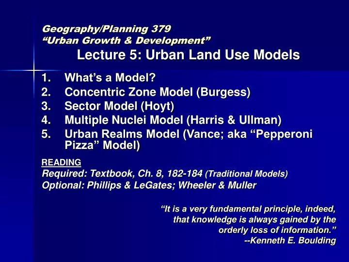
Geography/Planning 379 “Urban Growth & Development” Lecture 5: Urban Land Use Models What’s a Model? Concentric Zone Model (Burgess) Sector Model (Hoyt) Multiple Nuclei Model (Harris & Ullman) Urban Realms Model (Vance; aka “Pepperoni Pizza” Model) READING

E N D
Geography/Planning 379 “Urban Growth & Development” Lecture 5: Urban Land Use Models What’s a Model? Concentric Zone Model (Burgess) Sector Model (Hoyt) Multiple Nuclei Model (Harris & Ullman) Urban Realms Model (Vance; aka “Pepperoni Pizza” Model) READING Required: Textbook, Ch. 8, 182-184 (Traditional Models) Optional: Phillips & LeGates; Wheeler & Muller “It is a very fundamental principle, indeed, that knowledge is always gained by the orderly loss of information.” --Kenneth E. Boulding
1. What’s a model? • Best synonym: a model = “a representation” • A textbook definition: An idealized representation of a part of reality which is constructed so as to demonstrate certain of its properties.--Yeates and Garner, The North American City
1.What’s a model? Different kinds of models: • Scale or “iconic” models~ English model village http://www.bekonscot.com/models/ • Analogue models~ transform some properties to simulate real system • Conceptual models~ideas about how a system functions Three classic conceptual urban models: • One by a sociologist • One by a land economist • One by geographers
2. The Concentric-Zone Model • Proposed by Burgess – A sociologist at the University of Chicago: 1925 book titled The City • Based on a study of land use patterns and social group dynamics in Chicago • Geographically the city was visualized like 5 or 6 major rings, such as from a cross-section of a tree
New field in 1920s called human ecology based on ideas from biology such as: • Plant invasion • Species succession • Climax vegetation • Urban ecology: groups of people occupy over time different areas of the city like different plant species • Burgess said the zones were rings…
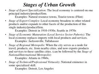
2. The Concentric-Zone Model 5 • Model based on Chicago, so rings are only semi-circular due to Lake Michigan 1A CBD Proper 1B Fringe of CBD 2 Zone in Transition or ‘Gray Zone’ 3 Lower Income Housing 4 Higher Income Housing 5 Commuters’ Zone 4 3 2 Wholesaling, warehousing, truck & railroad depots >>things that service CBD uses; cannot afford extreme land values of CBD proper; may need more land These uses haved moved out to circumpherential highways CBD = “Central Business District” In Chicago: “The Loop” Dept stores, office bldgs, banks, hotels, theaters >> things that service entire metro area 1B 1A Mixed residential and commercial usesOlder residential area; former homes of well-to-do have trickled down to low-income; Businesses and light manufacturing, print shopsZone of slums, rooming houses, newly arrived immigrants Suburban areas containing satellite cities Burgess called this ring: “Zone of Independent Workers’ Housing”Industrial workers. May have moved out from Zone 2 boarding houses as begin to assimilate, prosper, start families Important theoretical under-pinnings for this model provided by economists such as Alonso and Muth (who borrowed von Thunen’s ideas!) Single-family residences; streetcar suburbs
3. The Sector Model • This model proposed by a land economist working for U.S. federal government named Homer Hoyt • Based his model on a huge study of housing values in more than 100 cities • He posited a CBD around which other land uses cluster
3. The Sector Model • But important factor is not distance from CBD as in the concentric zone model, but direction away from CBD • Wedge-shaped land use zones: like pieces of pie • Does the “side” of town matter in Tucson?
3. The Sector Model (continued) • CBD • Wholesale & Light Manufacturing • Low-income Residential • Middle-Income Residential • High-Income Residential • SOURCE: http://www.geog.umontreal.ca/geotrans/eng/ch6en/conc6en/sectornuclei.html • Adapted from: H. Carter (1995) Urban Geography 4th Edition. London: Arnold, p. 126. • Which side is high-class residential? Why? • Why is lower-class residential where it is shown? • Discuss: Concept of “environmental justice”
3. The Sector Model (continued) • As growth occurs, similar activities stay in the same area and extendoutwards • Good for accommodating growth • Development axes; growth momentum • Concentric zone model requires redevelopment to change the amount of residential land use of different types • Why do land use areas take wedge shapes? • Follow older radial transport lines • High-class residential on higher ground or along an environmental amenity (e.g., wooded ravine) • Lower-class residential along “the tracks” coming in and out of town
3. The Sector Model (continued) • This theory is particularly good for residential land use • Both the concentric zone and sector models are monocentric representations of urban areas • How realistic are they for an auto-age metropolis like Tucson?
4.Multiple Nuclei Model • Developed by two geographers: Chauncey Harris & Edward Ullman in 1945 based on Seattle, Washington • Basic concept: cities don’t grow up around a single core but have several nodes • CBD need not be at the center (!) • Proximity to other locations (universities, airport, malls) can generate clusters of high-intensity land use
4.Multiple Nuclei Model • CBD • Wholesale & Light Manufacturing • Low-income Residential • Middle-Income Residential • High-Income Residential • Heavy Manufacturing • Outlying Business District (Mall) • Residential Suburb • Industrial Suburb • SOURCE: http://www.geog.umontreal.ca/geotrans/eng/ch6en/conc6en/sectornuclei.html
5. Urban Realms Model • Are any of these models just like Tucson? • Not the point of a model to exactly replicate all aspects of reality • How can a model be extended to become more realistic? • Example: Starfish-like growth during streetcar suburbs era with Concentric Zone Model (sketch)
5. Urban Realms Model • Today: A new urban reality that is not totally captured by any of the three standard pre-1950s models • Geographer James Vance in 1964 proposed “Urban Realms” (aka “Pepperoni Pizza”) model to describe Metropolitan L.A. • La-La Land is a vast poly-nucleated region linked by freeways and long-distance commuters
POP QUIZ Name ___________ Name that model: Proposed by a land economist, Homer Hoyt, it posits that different categories of housing occupy wedge-shaped areas radiating out from the CBD… Sector Model