Download
1 / 6
60 likes | 180 Views
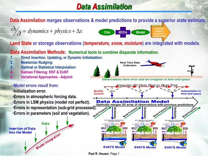
D ata A ssimilation. Data Assimilation merges observations & model predictions to provide a superior state estimate. Land State or storage observations ( temperature, snow, moisture ) are integrated with models. . Data Assimilation Methods: Numerical tools to combine disparate information.

E N D
Data Assimilation Data Assimilation merges observations & model predictions to provide a superior state estimate. Land State or storage observations (temperature, snow, moisture) are integrated with models. • Data Assimilation Methods:Numerical tools to combine disparate information. • Direct Insertion, Updating, or Dynamic Initialization: • Newtonian Nudging: • Optimal or Statistical Interpolation: • Kalman Filtering: EKF & EnKF • Variational Approaches - Adjoint: • Model errors result from: • Initialization error. • Errors in atmospheric forcing data. • Errors in LSM physics (model not perfect). • Errors in representation (sub-grid processes). • Errors in parameters (soil and vegetation).
Land Surface Data Assimilation Summary SSM/I Snow Observation Assimilation with Bias Correction Observation No Assimilation Assimilation Data Assimilation merges observations & model predictions to provide a superior state estimate. Remotely-sensed hydrologic state or storage observations (temperature, snow, soil moisture) are integrated into a hydrologic model to improve prediction, produce research-quality data sets, and to enhance understanding. Snow Cover Assimilation Theory Development Soil Moisture Assimilation Snow Water Assimilation Skin Temperature Assimilation
External LIS Internal Land Information Systemhttp://lis.gsfc.nasa.gov Co-PIs:P. Houser, C. Peters-Lidard 2005 NASA SOY co-winner!! Summary:LIS is a high performance set of land surface modeling (LSM) assimilation tools. Applications:Weather and climate model initialization and coupled modeling, Flood and water resources, precision agriculture, Mobility assessment … 200 Node “LIS” Cluster Optimized I/O, GDS Servers
Soil Moisture (May 2001) SW down ET U.MD AVHRR-Veg Cover Tsurface Merged Ppt Forcing Snow WE Objective:A 1/4 degree (and other) global land modeling and assimilation system that uses all relevant observed forcing, storages, and validation. Expand the current N. American LDAS to the globe. 1km global resolution goal Consistent Global Intercomparison Observed Forcing Land Data Assimilation CEOP
Summary of Selected LDAS Projects Merged Downward Shortwave Radiation (W/m2) 00Z 4/29/02 Global GSWP (Dirmeyer) MENA A-LDAS (Bolton) U.S. NLDAS (NOAA/NASA) Global GLDAS (Rodell) S. America SALDAS (Degoncalves) Europe ELDAS (Van Den Hurk) West Africa AMMA/African LDAS Japan CALDAS (Koike) Korea KLDAS (Byun) Canada CALDAS (Belair) Australia Australian LDAS France French LDAS (Boone) U.S. HRLDAS (Chen) U.S. Ameriflux DAS (Oak Ridge) EO-LDAS (ESA) China CN-LDAS (Xin)
Vision: A near-real time “patched” Global LDASAction: Overlay high-res regional LDAS model forcing and output over baseline low-res GLDAS model for best local informationAdvantage: Share land-hydrology data/forcing globally in a Hydrologic “GTS” frameworkIssues: Global consistency studies


![d ata[0]](https://cdn1.slideserve.com/3300577/slide1-dt.jpg)