Download
1 / 2
20 likes | 153 Views
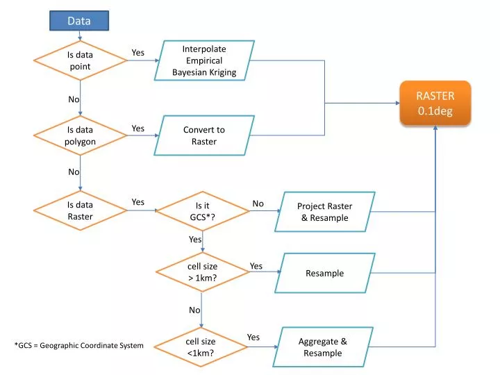
Data. Interpolate Empirical Bayesian Kriging. Is data point. Yes. RASTER 0.1deg. No. Is data polygon. Convert to Raster. Yes. No. Is data Raster. Is it GCS*?. Project Raster & Resample. Yes. No. Yes. cell size > 1km?. Resample. Yes. No. cell size <1km?. Aggregate & Resample.

E N D
Data Interpolate Empirical Bayesian Kriging Is data point Yes RASTER 0.1deg No Is data polygon Convert to Raster Yes No Is data Raster Is it GCS*? Project Raster & Resample Yes No Yes cell size > 1km? Resample Yes No cell size <1km? Aggregate & Resample Yes *GCS = Geographic Coordinate System
Interpolate Empirical Bayesian KrigingArcToolbox: Geostatistical Analysis> Empirical Bayesian Kriging. • Input: points • Output Parameters: • Output surface type: PREDICTION. • Run a second time with Output Parameters- Output Surface Type: PREDICTION STANDARD ERROR Project Raster ArcToolbox: Data Management Tools>Projections and Transformations>Raster>Project Raster Resample ArcToolbox: Data Management>Raster> Raster Processing>Resample Convert to Raster ArcToolbox: Conversion Tools> Polygon to Raster Aggregate ArcToolbox: Spatial Analyst>Generalization>Aggregate