Download
1 / 20
200 likes | 343 Views
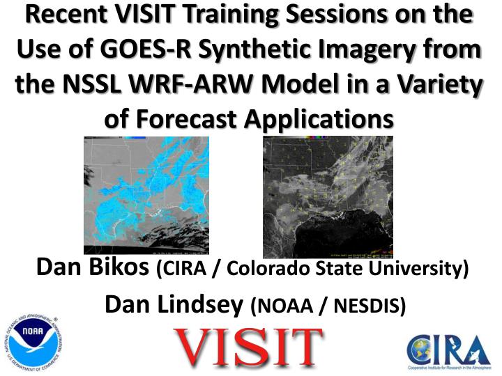
Recent VISIT Training Sessions on the Use of GOES-R Synthetic Imagery from the NSSL WRF-ARW Model in a Variety of Forecast Applications. Dan Bikos (CIRA / Colorado State University) Dan Lindsey (NOAA / NESDIS). Outline. Brief summary about synthetic imagery produced at CIRA.

E N D
Recent VISIT Training Sessions on the Use of GOES-R Synthetic Imagery from the NSSL WRF-ARW Model in a Variety of Forecast Applications Dan Bikos (CIRA / Colorado State University) Dan Lindsey (NOAA / NESDIS)
Outline Brief summary about synthetic imagery produced at CIRA. Summarize VISIT training sessions on applications of the synthetic imagery: Orographic cirrus Severe thunderstorms Low cloud / fog Extra-tropical cyclogenesis Sky cover / surface temperature forecasting (coming soon) Improvements / new products based on feedback.
Synthetic Imagery Summary NSSL 4-km WRF-ARW model run at 0000 UTC. Certain model output fields, including cloud water, cloud ice, temperature, water vapor, etc, are sent to CIRA and CIMSS. These WRF outputs are used as inputs to a model that generates the synthetic imagery Gaseous absorption is calculated for cloud-free grid points, and Modified Anomalous Diffraction Theory is used to obtain scattering and absorption by the cloud particles The model outputs brightness temperatures for a number of satellite bands. More information (June 2012 WAF):Bikos, D., Lindsey, D.T., Otkin, J., Sieglaff, J., Grasso, L., Siewert, C., Correia Jr., J., Coniglio, M., Rabin, R., Kain, J.S., and S. Dembek, 2012: Synthetic Satellite Imagery For Real-Time High Resolution Model Evaluation. Wea. Forecasting,27,784-795.
Synthetic Imagery GOES-R: 6.95 µm 10.35 µm 7.34 µm Current GOES: 6.5 µm 10.7 µm 7.4 µm (sounder) We generate hourly output for the 9- to 36-hour forecasts, valid 09Z of Day 1 to 12Z of Day 2 The bands are those that will be on GOES-R but the same principles can be applied to current GOES bands.
Utilizing Synthetic Imagery from the NSSL 4-km WRF-ARW model in forecasting Orographic Cirrus Dan Bikos and Dan Lindsey Acknowledgements: Louie Grasso, Bob Rabin, Jack Kain, Hiro Gosden, Deb Molenar
Orographic cirrus is more readily identified compared to looking at model output fields such as relative humidity. • Increased temporal resolution – hourly rather than model output times (NAM – 3 hourly ; GFS - 6 hourly)
Utilizing Synthetic Imagery from the NSSL 4-km WRF-ARW model in forecasting Severe Thunderstorms Dan Bikos and Dan Lindsey WRF-ARW GOES WRF-ARW GOES Acknowledgements: Louie Grasso, Bob Rabin, Jack Kain, Hiro Gosden, Deb Molenar
Synthetic 10.35 µm 13 hr forecast valid 1300 UTC 12 May 2010 GOES 10.7 µm 1302 UTC 12 May 2010 • MCS’s in the synthetic imagery are often full of holes and vastly underdone in terms of the areal extent of anvil cirrus.
The main role of the synthetic water vapor imagery is identifying shortwaves and jet streaks that may play a role in the initiation, maintenance and intensity of convection. WRF-ARW GOES
Utilizing Synthetic Imagery from the NSSL 4-km WRF-ARW model in Forecasting Low Clouds and Fog Dan Bikos and Dan Lindsey Acknowledgements: Louie Grasso, Bob Rabin, Jack Kain, Hiro Gosden, Deb Molenar
Utilizing Synthetic Imagery from the NSSL 4-km WRF-ARW model in Forecasting Cyclogenesis Dan Bikos and Dan Lindsey Acknowledgements: Louie Grasso, Bob Rabin, Jack Kain, Hiro Gosden, Deb Molenar
Identify cyclogenesis features we’re familiar with in GOES imagery in the WRF-ARW synthetic imagery. • Comparison between synthetic and GOES imagery to assess confidence in the evolution of cyclogenesis.
Improvements based on Feedback A common request has been: Can we get the model cloud output itself near the surface, to avoid the problem of intervening high clouds? Action: Experimental fog forecast product from NSSL WRF:
Improvements based on Feedback The most common request has been: Can we get the model 3-dimensional cloud output directly into our GFE? Action: Based on this request, will debut sky cover / temperature forecast training with instructions on how to display model output in the GFE.
Improvements based on Feedback Another request has been: Can we overlay model fields from the existing operational NAM? Run past 36 hours? Action: 4-km NAM-Nest imagery now being produced. 60 hr forecast. 10.7 µm band.
Feedback on Synthetic Imagery Eric Thaler, SOO at Boulder: “In my 30 years in the NWS, these synthetic satellite images are in my list of most exciting/useful innovations to help with operational forecasting. Indeed yesterday was an absolutely phenomenal case whereby the synthetic imagery gave me more confidence in the QPF that the models were predicting. What appeared to be a dry airmass upstream turned into a precipitation maker (lightning, too!) and the synthetic satellite imagery showed this absolutely wonderfully. Combining the output with QG diagnostics makes it even more helpful. It also did a superb job showing the clearing overnight. KEEP THE DATA COMING!!!!” Jon Zeitler, SOO at Austin/San Antonio: “Thanks again to everyone involved with the project and for working with us to get the product directly into AWIPS! It's greatly increased our confidence in forecasting the timing and areal coverage of low clouds/fog.”
Where to view synthetic imagery GOES-R proving ground (PG) products available in AWIPS via LDM Offices receiving PG products have been providing feedback to the developers. 4 km NSSL WRF-ARW synthetic imagery from CIRA: http://rammb.cira.colostate.edu/ramsdis/online/goes-r_proving_ground.asp Experimental Fog Product from NSSL WRF-ARW and NAM-Nest Synthetic Imagery found here: http://rammb.cira.colostate.edu/training/visit/links_and_tutorials/
Contact Questions? Dan Bikos: Dan.Bikos@colostate.edu Dan Lindsey: Dan.Lindsey@noaa.gov