Download
1 / 18
180 likes | 186 Views
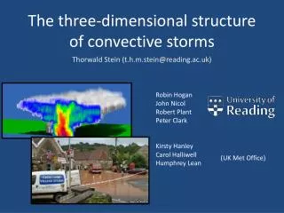
Track and analyze convective storms in real-time using the Chilbolton radar. Derive properties of storms including vertical velocity, 3D structure, rain and hail, ice water content, and more. Evaluate these properties in different model configurations and resolutions. Estimate updrafts and characterize storm intensity and spatial scale. Explore scientific and modeling questions related to storm structure, hail occurrence, turbulence, and more.

E N D
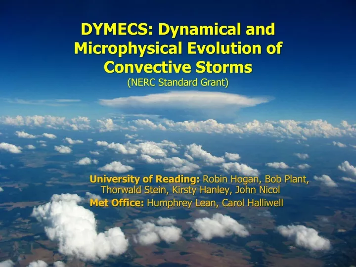
University of Reading: Robin Hogan, Bob Plant, Thorwald Stein, Kirsty Hanley, John Nicol Met Office: Humphrey Lean, Carol Halliwell DYMECS: Dynamical and Microphysical Evolution of Convective Storms(NERC Standard Grant)
The DYMECS approach: beyond case studies Track storms in real time and automatically scan Chilbolton radar Derive properties of hundreds of storms on ~40 days: • Vertical velocity • 3D structure • Rain & hail • Ice water content • TKE & dissipation rate NIMROD radar network rainfall Evaluate these properties in model varying: • Resolution • Microphysics scheme • Sub-grid turbulence parametrization
Nimrod radar 1.5-km model 500-m model 200-m model Kirsty Hanley
Nimrod radar 1.5-km model Too few 500-m model 200-m model Too many Kirsty Hanley
Smagorinsky mixing length plays a key role in determining number of small storms Storm size distribution 1.5-km model 500-m model Kirsty Hanley
20 April 2012 25 Aug 2012 500-m model best 200-m model best 1.5-km model best 200-m model best Kirsty Hanley
First 60% of storms by cloud-top height Next 30% Top 10% Observations 1.5-km model 1.5-km + graupel Vertical profile Ice density too low? Higher reflectivity core Thorwald Stein
First 60% of storms by cloud-top height Next 30% Top 10% Observations 200-m model 500-m model Vertical profile Thorwald Stein
Estimation of vertical velocities from continuity • Vertical cross-sections (RHIs) are typically made at low elevations (e.g. < 10°) • Radial velocities provide accurate estimate of the horizontal winds • Assume vertical winds are zero at the surface • Working upwards, changes in horizontal winds at a given level increment the vertical wind up to that point • Must account for density change with height Key uncertainty in models is convective updraft intensity and spatial scale Can we estimate updrafts from Doppler wind sufficiently well to characterize the distribution of intensity and spatial scale? John Nicol
Estimating retrieval errors from the Unified Model Vertical wind (m/s) Reflectivity (dBZ) Retrieved vertical wind (m/s) Horizontal wind (m/s) Retrieval error (m/s) John Nicol
dBZ u (m/s) w (m/s) 12:45 07 August 2011 16:37 07 August 2011 John Nicol
Scientific and modelling questions • What is magnitude and scale of convective updrafts? How do two observational methods compare to model at various resolutions? • What model configurations lead to the best 3D storm structure and evolution, and why? • How good are predictions of hail occurrence and turbulence? • How is boundary-layer grey zone best treated at high resolution, and what is the role of the Smagorinsky length scale? • Does BL scheme “diffuse away” gust fronts necessary to capture triggering of daughter cells and if so how can this be corrected? • Can models distinguish single cells, multi-cell storms & squall lines, and the location of daughter cells formed by gust fronts? • What are the characteristics common to quasi-stationary storms in the UK from the large DYMECS database? • Can we diagnose parameters that should be used in convection schemes from observations?
The “blob analysis” Does the surface rain rate look right in a couple of cases? If not, how do we fix the model? 16.00 on 26 August 2011 Met Office 1.5 km model Radar observations Rain rate (mm h-1) Forecast plan-view of rainfall NIMROD radar network rainfall
WP 3. Derive properties from radar scans • Cloud area, cloud-top height versus time into cell lifecycle • Surface rain rate, drop size, hail intensity from polarization variables (Hogan 2007) • Ice water content using radar reflectivity and temperature (Hogan et al. 2006) • TKE and dissipation rate from Doppler spectral width (Chapman and Browning 2001) • Updrafts…
Chapman & Browning (1998) • In quasi-2D features (e.g. squall lines) can assume continuity to estimate vertical velocity Updrafts? • Hogan et al. (2008) • Track features in radial velocity from scan to scan
WP4. Statistical analysis of observed storms Alan Grant (2007) suggested the following “testable relationships” in convection parameterization: where • eup is the mean in-cloud dissipation rate • wup is the cumulus vertical velocity scale • Lup is the horizontal length scale of the updrafts • Aup is the fractional area of some horizontal domain occupied by cumulus updrafts (equal to the cloud-base mass flux in a convection scheme divided by wup) • Dcld is the depth of the convective cloud layer • CAPE is the convective available potential energy
WP6. Modelling case studies & sensitivity tests • We use MONSooN so can share jobs between University and Met Office • Horizontal resolution • Down to 100 m; model currently predicts smaller cells as resolution increases • Sub-grid mixing scheme • Test 2D & 3D Smagorinsky, prognostic TKE and a stochastic backscatter scheme • Evaluate rate of change of cloud size with time, and TKE • Microphysical scheme • Test single- and double-moment liquid, rain, ice, snow, graupel and possibly hail, as well as interactive aerosol-cloud microphysics