Download
1 / 19
190 likes | 383 Views
. . . Real people. Real catchments. Real answers. Hydrology for the Environment, Life and Policy. To deliver social, economic and environmental benefit to stakeholders through sustainable and appropriate use of water by directing hydrological science towards improved integrated catchment management basins.

E N D
3. �Paradigm Lock�
4. The HELP Process A comprehensive assessment of what we know now (physical, socio-economic, legal, cultural baseline information).
Iteration between stakeholders and scientists to determine research plan.
Implementation of research in collaboration between scientists, managers and stakeholders
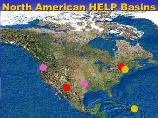
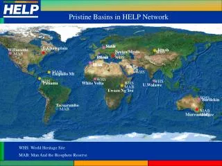
5. What makes HELP unique? Only international programme that is a catchment based activity which is interfacing scientific research with stakeholders needs.
Includes scientists, stakeholders, policy-makers, lawyers, environmentalists, etc.
Provides options as against imposing solutions.
Providing/testing/implementing and improving solutions.
IHP cross cutting program
Sharing experiences across a global network of basins.
6. Who are we? Teams of scientists (natural, social, economic, political) stakeholders, managers, policy and decision makers.
Focusing on �needs driven� water related issues and research.
International platform for basin experiences (comparing/sharing).
Contribution towards IWRM.
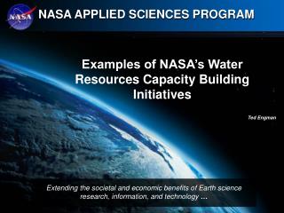
8. NASA�s applied sciences program is rather new � NASA always been known for its theoretical and basic science. The applied sciences program is designed to see if NASA`data and data products can be used to improve current operational procedures.
NASA�s applied sciences program is rather new � NASA always been known for its theoretical and basic science. The applied sciences program is designed to see if NASA`data and data products can be used to improve current operational procedures.
9. NASA�s applied sciences program is rather new � NASA always been known for its theoretical and basic science. The applied sciences program is designed to see if NASA`data and data products can be used to improve current operational procedures.
NASA�s applied sciences program is rather new � NASA always been known for its theoretical and basic science. The applied sciences program is designed to see if NASA`data and data products can be used to improve current operational procedures.
10. NASA�s applied sciences program is rather new � NASA always been known for its theoretical and basic science. The applied sciences program is designed to see if NASA`data and data products can be used to improve current operational procedures.
NASA�s applied sciences program is rather new � NASA always been known for its theoretical and basic science. The applied sciences program is designed to see if NASA`data and data products can be used to improve current operational procedures.
11. NASA MISSIONS FOR WATER MANAGEMENT These are the suite of existing and planned NASA missions that may be useful for water management These are the suite of existing and planned NASA missions that may be useful for water management
12. Many various land surface observations are required for successful implementation of land data assimilation systems. Many are listed here, with the ones in red being the most important and least well observed.Many various land surface observations are required for successful implementation of land data assimilation systems. Many are listed here, with the ones in red being the most important and least well observed.
13. Accurate land model prediction is essential to enable data assimilation methods to propagate or extend scarce observations in time and space. Land surface prediction models are based on water and energy balance (Input - Output = Storage Change), as well as various parameterizations that control the proceses depicted in the figures. There are hundreds of land surface models; we have focused on a few: Mosaic (Koster, 1996) is based on simple SiB physics, but includes a subgrid scale "mosaic� of vegetation patches. The CLM (Community Land Model, ~2001) is a community developed �open-source� model featuring 10 soil layers and a 5 layer snow scheme. The Catchment Model (Koster et al., 2000), models in catchment space rather than on grids, and uses Topmodel concepts to model groundwater. The NOAA-NCEP-NOAH Model (NCEP, ~2001), is the operational land surface model used by NOAA in operational prediction.
Accurate land model prediction is essential to enable data assimilation methods to propagate or extend scarce observations in time and space. Land surface prediction models are based on water and energy balance (Input - Output = Storage Change), as well as various parameterizations that control the proceses depicted in the figures. There are hundreds of land surface models; we have focused on a few: Mosaic (Koster, 1996) is based on simple SiB physics, but includes a subgrid scale "mosaic� of vegetation patches. The CLM (Community Land Model, ~2001) is a community developed �open-source� model featuring 10 soil layers and a 5 layer snow scheme. The Catchment Model (Koster et al., 2000), models in catchment space rather than on grids, and uses Topmodel concepts to model groundwater. The NOAA-NCEP-NOAH Model (NCEP, ~2001), is the operational land surface model used by NOAA in operational prediction.
14. Land surface data assimilation merges observations & model predictions to provide a superior state estimates. Remotely-sensed hydrologic state or storage observations (temperature, snow, soil moisture) are integrated into a hydrologic model to improve prediction, produce research-quality data sets, and to enhance understanding of complex hydrologic phenomenon. Land surface data assimilation is like driving your car down the road with your eyes closed, only opening them every few seconds to correct your trajectory (do not try this at home). Your glimpses of reality are essentially observations that help you to correct your model trajectory (car direction) to help you stay on the road (i.e. constrained to reality). The figures show classic example of the power of land surface soil moisture data assimilation, where new observations are used to correct a model trajectory. However, notice that the observations have small scale errors that are not characteristic of the larger scale spatial statistics. The assimilation technique used here filters out these errors so as to not introduce observation error into the prediction.
Land surface data assimilation merges observations & model predictions to provide a superior state estimates. Remotely-sensed hydrologic state or storage observations (temperature, snow, soil moisture) are integrated into a hydrologic model to improve prediction, produce research-quality data sets, and to enhance understanding of complex hydrologic phenomenon. Land surface data assimilation is like driving your car down the road with your eyes closed, only opening them every few seconds to correct your trajectory (do not try this at home). Your glimpses of reality are essentially observations that help you to correct your model trajectory (car direction) to help you stay on the road (i.e. constrained to reality). The figures show classic example of the power of land surface soil moisture data assimilation, where new observations are used to correct a model trajectory. However, notice that the observations have small scale errors that are not characteristic of the larger scale spatial statistics. The assimilation technique used here filters out these errors so as to not introduce observation error into the prediction.
15. Quantification and prediction of hydrologic variability is critical for initialization and improvement of weather/climate forecasts, and is critical for applications such as floods, agriculture, military operations, etc. Over the pate few years, we have seen significant maturing of hydrologic observation and prediction tools: Land surface observation tools: Observations of land surface forcing, storages(states), fluxes, and parameters are becoming more readily available. Land surface simulation tools: Land process models (Hydrology, Biogeochemistry, etc.) have evolved significantly over the past 15 years. Land surface data assimilation tools: land surface data assimilation tools have emerged to provide short-term state constraints based on observations, thus further improving predictions. This has lead to the development of the Land Data Assimilation System �LDAS� concept, which is aimed at bringing state-of-the-art tools together to operationally obtain high quality land surface conditions and fluxes. This is envisioned to occur through the optimal integration of land surface observations and predictions, continuous in time & space, at multiple scales, and in retrospective, realtime, and forecast modes.
Quantification and prediction of hydrologic variability is critical for initialization and improvement of weather/climate forecasts, and is critical for applications such as floods, agriculture, military operations, etc. Over the pate few years, we have seen significant maturing of hydrologic observation and prediction tools: Land surface observation tools: Observations of land surface forcing, storages(states), fluxes, and parameters are becoming more readily available. Land surface simulation tools: Land process models (Hydrology, Biogeochemistry, etc.) have evolved significantly over the past 15 years. Land surface data assimilation tools: land surface data assimilation tools have emerged to provide short-term state constraints based on observations, thus further improving predictions. This has lead to the development of the Land Data Assimilation System �LDAS� concept, which is aimed at bringing state-of-the-art tools together to operationally obtain high quality land surface conditions and fluxes. This is envisioned to occur through the optimal integration of land surface observations and predictions, continuous in time & space, at multiple scales, and in retrospective, realtime, and forecast modes.
18. NASA�s applied sciences program is rather new � NASA always been known for its theoretical and basic science. The applied sciences program is designed to see if NASA`data and data products can be used to improve current operational procedures.
NASA�s applied sciences program is rather new � NASA always been known for its theoretical and basic science. The applied sciences program is designed to see if NASA`data and data products can be used to improve current operational procedures.
19. NASA�s applied sciences program is rather new � NASA always been known for its theoretical and basic science. The applied sciences program is designed to see if NASA`data and data products can be used to improve current operational procedures.
NASA�s applied sciences program is rather new � NASA always been known for its theoretical and basic science. The applied sciences program is designed to see if NASA`data and data products can be used to improve current operational procedures.