Download
1 / 16
160 likes | 285 Views
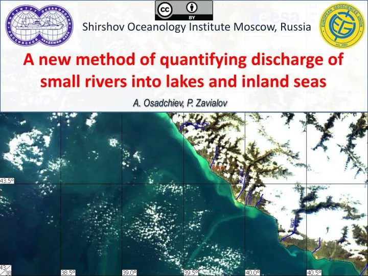
Shirshov Oceanology Institute Moscow, Russia. A new method of quantifying discharge of small rivers into lakes and inland seas. A . Osadchiev , P . Zavialov. Motivation. 1. Importance of river discharge estimates :

E N D
ShirshovOceanology Institute Moscow, Russia A new method of quantifying discharge of small rivers into lakes and inland seas A. Osadchiev, P. Zavialov
Motivation • 1. Importance of river discharge estimates: • Continental discharge is an important component of the global hydrological cycle (about 10% of the input part of the water budget of the ocean); • Buoyant inflow usually causes surface density stratification at the large shelf areas, and plays a significant role in physical, chemical, and biological processes there; • For the inland seas and certain shelf areas, fluvial discharges can play much more significant role. • 2. Complexity of river discharge estimation: • Direct measurements of discharge are expensive and laborious; • Indirect methods of river discharge estimation require ancillary ground-based information (e.g., gauge measurements, bathymetry, etc.) and are prone to uncertainties ; • There is a lack of discharge data for most of rivers in a global scale
River Discharge= River Plume + Dissipation River plumes can be recognized and identified using satellite imagery Schematic of a plume interaction with ambient environment
Principal scheme of estimating river discharge The initial satellite image. Suspended sediment concentration is used as a plume tracer.
Principal scheme of estimating river discharge • The initial satellite image. Suspended sediment concentration is used as a plume tracer. • Identification of border and spatial structure of the plume.
Principal scheme of estimating river discharge Q τ • The initial satellite image. Suspended sediment concentration is used as a plume tracer. • Identification of border and spatial structure of the plume. • Prescribing river discharge and external forcing model • configuration
Principal scheme of estimating river discharge Q τ • The initial satellite image. Suspended sediment concentration is used as a plume tracer. • Identification of border and spatial structure of the plume. • Prescribing river discharge and external forcing model • configuration • Modeling river plume under • prescribed conditions
STRiPE ‒ Lagrangian model of a river plume Transport equation for a particle wind stress pressure gradient force Coriolis force vertical friction lateral friction Schematic of the forces applied to an individual particle of the plume wind stress Coriolis force pressure gradient force interpolation lateral friction particle acceleration particle velocity vertical friction modeled particle distribution interpolated river plume salinity diffusion More details at:A. Osadchiev and P. Zavialov.Lagrangian model of a surface-advected river plume. Continental Shelf Research. 58: 96-106. 2013.
Details High variability of river plume is caused by variability of external forcing conditions, mainly, wind stress and discharge => we need to perform big number of model runs to simulate river plume under external forcing conditions with high resolution to determine the exact discharge; The main advantage of STRiPEcomparing to widely used Eulerian models (e.g., POM, ROMS, etc.) is its low computational cost, which enabled us to perform about 2000 simulations of the Mzymta River plume under various forcing and discharge conditions. The simulation results were organized as a data base, so the most similar river plume among the modeled results could be quickly found for every satellite image of the plume. … … … … … … Data base of river plumes simulated under various conditions
Principal scheme of estimating river discharge Q τ • The initial satellite image. Suspended sediment concentration is used as a plume tracer. • Identification of border and spatial structure of the plume. • Prescribing river discharge and external forcing model • configuration • Modeling river plume under • prescribed conditions • 5. Comparing the modeled and the • observed plumes.
Details In most cases there is no complete coincidence of the satellite plume image and best-fitting model result. Therefore similarity between satellite and modeled plumes is evaluated in two ways, comparison of their areas and comparison of their contours (e.g., normalized contour-vectors). plume area = N km2
Principal scheme of estimating river discharge Q τ river discharge = Q m3/s
Summary and conclusions • A method of estimating river discharge using satellite imagery and numerical modeling is developed. This method is an alternative for the expensive and laborious direct measurements of the river discharge. • This method was applied to the Mzymta River plume and was used to estimate the discharge rate of Mzymta River during the trial period (June-December, 2011). The method was verified against the in situ gaugemeasurements and showed good ability to produce realistic results. Future work • The future improvement of the quality of satellite imagery on the one hand, and increasing of the computer performance on the other hand will result in growth of efficiency and accuracy of this method. • We are looking forward for applying the method to the whole Black Sea shore to estimate total river discharge to the Black Sea and evaluate the role of numerous small rivers and watersheds in the total discharge. • We plan to use several river plume tracers (e.g., temperature, chlorophyll, dissolved organic) for estimating borders of river plumes with low sediment concentration.