Download
1 / 1
10 likes | 137 Views
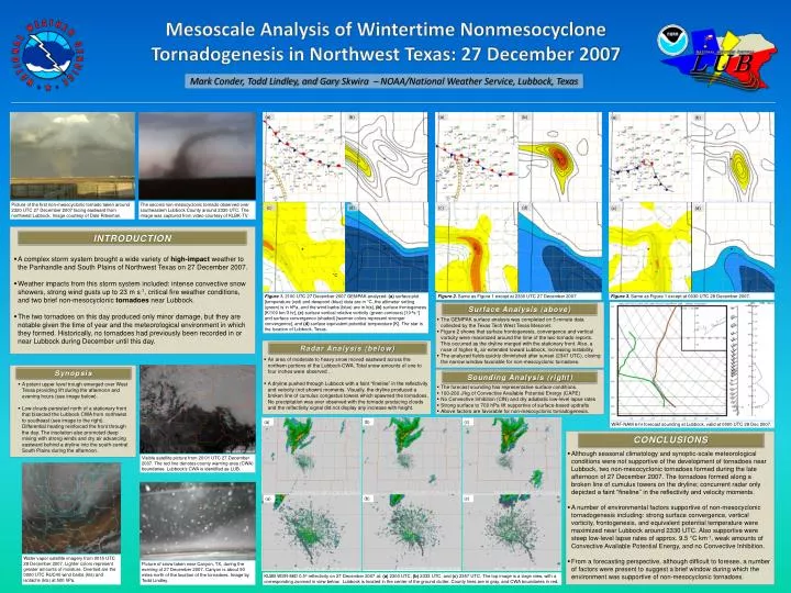
Mesoscale Analysis of Wintertime Nonmesocyclone Tornadogenesis in Northwest Texas: 27 December 2007. Mark Conder , Todd Lindley, and Gary Skwira – NOAA/National Weather Service, Lubbock, Texas. (a). (b). (a). (b). (a). (b). (c). (d). (c). (d). (c). (d).

E N D
Mesoscale Analysis of Wintertime Nonmesocyclone Tornadogenesis in Northwest Texas: 27 December 2007 Mark Conder, Todd Lindley, and Gary Skwira – NOAA/National Weather Service, Lubbock, Texas (a) (b) (a) (b) (a) (b) (c) (d) (c) (d) (c) (d) The second non-mesocyclonic tornado observed over southeastern Lubbock County around 2330 UTC. The image was captured from video courtesy of KLBK-TV. Picture of the first non-mesocyclonic tornado taken around 2320 UTC 27 December 2007 facing eastward from northwest Lubbock. Image courtesy of Dale Ritesman. CONCLUSIONS INTRODUCTION • Although seasonal climatology and synoptic-scale meteorological conditions were not supportive of the development of tornadoes near Lubbock, two non-mesocyclonic tornadoes formed during the late afternoon of 27 December 2007. The tornadoes formed along a broken line of cumulus towers on the dryline; concurrent radar only depicted a faint “fineline” in the reflectivity and velocity moments. • A number of environmental factors supportive of non-mesocyclonic tornadogenesis including: strong surface convergence, vertical vorticity, frontogenesis, and equivalent potential temperature were maximized near Lubbock around 2330 UTC. Also supportive were steep low-level lapse rates of approx. 9.5 °C km-1, weak amounts of Convective Available Potential Energy, and no Convective Inhibition. • From a forecasting perspective, although difficult to foresee, a number of factors were present to suggest a brief window during which the environment was supportive of non-mesocyclonic tornadoes. °C • A complex storm system brought a wide variety of high-impact weather to the Panhandle and South Plains of Northwest Texas on 27 December 2007. • Weather impacts from this storm system included: intense convective snow showers, strong wind gusts up to 23 m s-1, critical fire weather conditions, and two brief non-mesocyclonictornadoes near Lubbock. • The two tornadoes on this day produced only minor damage, but they are notable given the time of year and the meteorological environment in which they formed. Historically, no tornadoes had previously been recorded in or near Lubbock during December until this day. Figure 1. 2100 UTC 27 December 2007 GEMPAK analyzed: (a) surface plot [temperature (red) and dewpoint (blue) data are in °C, the altimeter setting (green) is in hPa, and the wind barbs (blue) are in kts], (b) surface frontogenesis [K/100 km/3 hr], (c) surface vertical relative vorticity (green contours) [10-5s-1] and surface convergence (shaded) [warmer colors represent stronger convergence], and (d) surface equivalent potential temperature [K]. The star is the location of Lubbock, Texas. Figure 2. Same as Figure 1 except at 2330 UTC 27 December 2007. Figure 3. Same as Figure 1 except at 0030 UTC 28 December 2007. Surface Analysis (above) • The GEMPAK surface analysis was completed on 5-minute data collected by the Texas Tech West Texas Mesonet. • Figure 2 shows that surface frontogenesis, convergence and vertical vorticity were maximized around the time of the two tornado reports. This occurred as the dryline merged with the stationary front. Also, a nose of higher θe air extended toward Lubbock, increasing instability. • The analyzed fields quickly diminished after sunset (2347 UTC), closing the narrow window favorable for non-mesocyclonic tornadoes. Radar Analysis (below) • An area of moderate to heavy snow moved eastward across the northern portions of the Lubbock CWA. Total snow amounts of one to four inches were observed . • A dryline pushed through Lubbock with a faint “fineline” in the reflectivity and velocity (not shown) moments. Visually, the dryline produced a broken line of cumulus congestus towers which spawned the tornadoes. No precipitation was ever observed with the tornado producing clouds and the reflectivity signal did not display any increase with height. Synopsis Sounding Analysis (right) • A potent upper level trough emerged over West Texas providing lift during the afternoon and evening hours (see image below). • Low clouds persisted north of a stationary front that bisected the Lubbock CWA from northwest to southeast (see image to the right). Differential heating reinforced the front through the day. The insolation also promoted deep mixing with strong winds and dry air advancing eastward behind a dryline into the south-central South Plains during the afternoon. • The forecast sounding has representative surface conditions. • 100-200 J/kg of Convective Available Potential Energy (CAPE) • No Convective Inhibition (CIN) and dry adiabatic low-level lapse rates • Strong surface to 700 hPa lift supportive of surface-based updrafts • Above factors are favorable for non-mesocyclonic tornadogenesis. (b) (c) (a) WRF-NAM 6-hr forecast sounding at Lubbock, valid at 0000 UTC 28 Dec 2007. Picture of snow taken near Canyon, TX, during the evening of 27 December 2007. Canyon is about 90 miles north of the location of the tornadoes. Image by Todd Lindley. (b) (c) (a) KLBB WSR-88D 0.5º reflectivity on 27 December 2007 at: (a) 2300 UTC, (b) 2333 UTC, and (c) 2357 UTC. The top image is a large view, with a corresponding zoomed in view below. Lubbock is located in the center of the ground clutter. County lines are in gray, and CWA boundaries in red. Water vapor satellite imagery from 0015 UTC 28 December 2007. Lighter colors represent greater amounts of moisture. Overlaid are the 0000 UTC RUC40 wind barbs (kts) and isotachs (kts) at 500 hPa. Visible satellite picture from 20:01 UTC 27 December 2007. The red line denotes county warning area (CWA) boundaries. Lubbock’s CWA is identified as LUB.