Download
1 / 22
220 likes | 333 Views
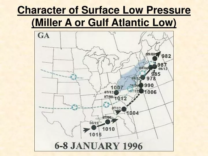
Character of Surface Low Pressure (Miller A or Gulf Atlantic Low). Miller A: February 1983. Animation of Surface Low. Character of Surface Low Pressure (Miller A or Gulf Atlantic Low).

E N D
Character of Surface Low Pressure (Miller A or Gulf Atlantic Low)
Miller A: February 1983 Animation of Surface Low
Character of Surface Low Pressure (Miller A or Gulf Atlantic Low) Miller A: Surface low tracks in a general northeast direction from the southeastern United States or the Gulf of Mexico. For us to have a good chance at receiving heavy snow, the low needs to stay to our south and east and preferably stay off the Delmarva Peninsula. It is also beneficial for the low to be just off the Virginia Capes while deepening and moving slowly in a NE or ENE direction.
HM—Miller A Threat (January 28, 2007) The story on the Miller A threat....The pattern goes like this, l/w carving out over the central usa w/ 3 different s/w in the flow....first s/w will race out ahead just before the main storm and move across the OH valley and north mid atlantic/new england w/ very minimal precipitation. The PV will continue to drop into southern canadian provinces and will force the heights lower in the l/wv. Therefore, the s/w will at some point "phase" and induce cyclogensis in western gulf of mexico which should fly up the east coast.Sounds beautiful dont it? Well, as classic as it sounds, it gets even more classic.... im sure you are all familar w/ this term... "rain at the coast, snow inland" ... The three s/w positions will determine the ultimate track, but im completely against any inland threat. The 00z GFS ensembles, 06z op GFS, ECMWF, UKIE, GGEM all against the 00z OP GFS inland solution. So in terms of models, the inland solution is far outweighed.
HM—Miller A Threat (January 28, 2007) The first s/w that runs out ahead will have some... some.... CAA and help position certain surface features. For the most part, it will not be a big player, but if it trends stronger, it could shift things at the surface for that of cooler in the east. It's affects wouldnt matter except for maybe the start of the precip on the east coast.The two s/w in the flow with one in Utah and the other in TX timing of "meshing" will determine ultimately track. Already you can see huge differences between 00z GFS inland run, and every other model. The trough is considerably further east on 06z GFS and every other operational model and most of the ensembles. Phasing /meshing takes place in southern plains/ms vally and the western GOM cyclogensis will rapidly race up the east coast in the fast flow. With Arctic air bleeding across midwest, gulf stream, and 120kt upper level jet, its possible this thing begins to intensify off mid atlantic coast from sub 1008mb to sub 995mb.
HM—Miller A Threat (January 28, 2007) At this point, FEB 2-3, a quick hitting storm should welcome the new month for the mid atlantic and new england. Despite having a coastal track, the fast flow up the east coast w/ no blocking in the atlantic/confluence in se canada, expect things to change to rain on the coastal plain. I anticipate a messy setup for majority of the east coast cities, but it will change to rain and end well above frz and wet. A considerable snow / ice potential exists inland md/pa into interior new england / upstate ny. For the most part, the cold air source is left over stale air w/ some CAA being pulled in from developing coastal storm. The bigger source of cold will be dropping into the midwest. PV will be in southern Canada will heights extending in a "trough like" pattern towards the northeast. So for now, expect a classic winter storm w/ rain at the coast, snow to mix to rain I95, ice in the interior where WAA pumps >0C in the mid levels but cold gets trapped, and then all snow inland.
HM—Miller A Threat (January 28, 2007) From this point on, I look for the Arctic air. The invasion w/ perhaps some of the coldest air of the whole season affecting most of the midwest into the northeast. Keep in mind the posts from above and apply those concepts to the ideas discussed in this post. This east coast runner has a lot of impact on the next potential threat period. How exactly it evolves and deepens can determine how the PV behaves in the FEB 7-12 period. It could potentially carve out lower heights SE in Canada/atlantic and setup the 500mb to be more condusive for SECS. The threat period would be in that DAY 10-15 period as PV begins to move into East canada and then revolve. IF... IF there is that potential lowered heights off the SE canadian coast b/c of the gulf storm, the atlantic could set up to allow a major east coast snow event/winter storm. Without it, we still need to pay attention b/c we will have plenty of Arctic air and the pacific will allow the STJ to bring more activity.
February 1-2, 2007 Storm: Why the Forecast Bust? Quick run down:- No negative NAO, no blocking, no 50/50 low- Upper level flow too flat and fast- Northern stream s/w didn't "pick up" the STJ wave, instead went towards the east- Lack of real phasing- Cold air was there, but no high to the north, thus eroded by first wave- Storm "split" into 2 frontal waves without a defined cyclone- Dry slot between 2 waves, convection robs moisture -Terpeast-
Character of Surface Low Pressure (Miller B or Atlantic Redevelopment Low)
Miller B: February 13-14, 2007 Miller B Storm: One surface low tracked into central Appalachians. Secondary low formed off the southeast coast and propagated NNE. Miller B Storm: One surface low tracked into central Appalachians. Secondary low formed off the southeast coast and propagated NNE. SNOW L L
Character of Surface Low Pressure (Miller B or Atlantic Redevelopment Low) Miller B: Surface low tracks from Northern Plains or Canada and dives southeast. This low weakens while a secondary or coastal low redevelops off the East coast. For Philadelphia to receive a heavy snow fall from a Miller B low requires a unique set of characteristics. The secondary (coastal) low must form to the south and east of Philadelphia. This low must also intensify, preferably in a rapid, bomb like, fashion yet be moving slowly. This low unlike the Miller A, is best for heavy snow when it moves in a more northerly direction rather than a NE or ENE direction.
Table V HINTS FOR FORECASTING MODERATE TO HEAVY SNOW (S+) Surface • Around 2 to 2.5 degrees latitude to the left of the track of the low (150-240 nm) • Approximately 5 degrees latitude ahead of the low • As long as low isdeepening, heavy snow will still occur • When low fills, the heavy snow usually ends. • When the cold surface anticyclone is to the N or NW--typically enhanced by confluent mid level flow • Optimum surface temperature 27 to 32F
Miller B: March 1960 March 1960 Surface Low Animation
Snowstorm Dynamics: Formation of Heavy Banded Snow Note how the cities along the I-95 corridor are often along the boundary between frozen and liquid precipitation. This makes winter weather forecasting one of the toughest forecasting aspects in ALL of meteorology.
Interior Snowstorm Characteristics: A Miss for Philadelphia The cyclone track is further west, usually crossing the Delmarva Peninsula. The cyclone also tracks in a more northerly direction going west of Cape Cod, Mass. Also, the high pressure is either too far north or too far east.
Interrelationships: Characteristics of Moderate Snowstorms High pressure systems are in a wide variety of locations. Many cyclonic redevelopment cases from the west and from the Gulf of Mexico. Wide variety of surface low tracks as well. However, all low tracks are south of Philadelphia. Moderate snowstorm events are the most capable events, outside the heavy snow events, to give Philadelphia an 8 inch or more snowfall.
Characteristics of All Snow Cases Versus Changeover Cases All snow cases. High pressure west of the state of Maine and north of PA/NY border. Changeover cases, high pressure is on top of the state of Maine or eastward.
Interrelationships: Characteristics of All Snow Cases Versus Changeover Cases To remain all snow, it is best if the low tracks NE or ENE staying away from coastline of the Northeast U.S. Why? If the low rides right up the coast, it pulls in too much low level warm air from the Atlantic Ocean. Therefore, the precipitation has a difficult time staying frozen throughout the entire atmosphere. Philadelphia can receive heavy snow from a changeover event, an interior event, and/or a moderate event. However, the chances of a widespread 8 inches or more across the entire Delaware Valley is very unlikely.