Download
1 / 1
10 likes | 129 Views
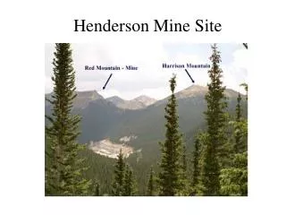
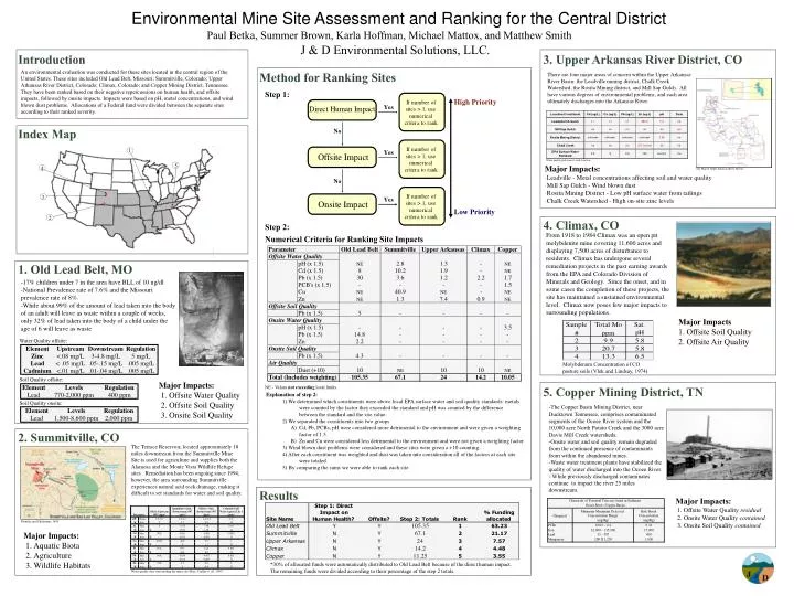
High Priority. Low Priority. Paul Betka, Summer Brown, Karla Hoffman, Michael Mattox, and Matthew Smith. J & D Environmental Solutions, LLC. Introduction. 3. Upper Arkansas River District, CO. Environmental Mine Site Assessment and Ranking for the Central District.

E N D
High Priority Low Priority Paul Betka, Summer Brown, Karla Hoffman, Michael Mattox, and Matthew Smith J & D Environmental Solutions, LLC. Introduction 3. Upper Arkansas River District, CO Environmental Mine Site Assessment and Ranking for the Central District An environmental evaluation was conducted for these sites located in the central region of the United States. These sites included Old Lead Belt, Missouri; Summitville, Colorado; Upper Arkansas River District, Colorado; Climax, Colorado; and Copper Mining District, Tennessee. They have been ranked based on their negative repercussions on human health, and offsite impacts, followed by onsite impacts. Impacts were based on pH, metal concentrations, and wind blown dust problems. Allocations of a Federal fund were divided between the separate sites according to their ranked severity. Method for Ranking Sites • There are four major areas of concern within the Upper Arkansas River Basin: the Leadville mining district, Chalk Creek Watershed, the Rosita Mining district, and Mill Sap Gulch. All have various degrees of environmental problems, and each area ultimately discharges into the Arkansas River. Step 1: Index Map 1 Water quality problems at each location. 5 Major Impacts: ·Leadville - Metal concentrations affecting soil and water quality·Mill Sap Gulch - Wind blown dust·Rosita Mining District - Low pH surface water from tailings ·Chalk Creek Watershed - High on-site zinc levels 4 Site Map of Upper Arkansas River District. 3 2 4. Climax, CO Step 2: From 1918 to 1984 Climax was an open pit molybdenite mine covering 11,600 acres and displaying 7,500 acres of disturbance to residents. Climax has undergone several remediation projects in the past earning awards from the EPA and Colorado Division of Minerals and Geology. Since the onset, and in some cases the completion of these projects, the site has maintained a sustained environmental level. Climax now poses few major impacts to surrounding populations. Numerical Criteria for Ranking Site Impacts 1. Old Lead Belt, MO St. Joe Company Photo -17% children under 7 in the area have BLL of 10 ug/dl-National Prevalence rate of 7.6% and the Missouri prevalence rate of 8%.-While about 99% of the amount of lead taken into the body of an adult will leave as waste within a couple of weeks, only 32% of lead taken into the body of a child under the age of 6 will leave as waste Major Impacts Offsite Soil Quality 2. Offsite Air Quality Water Quality offsite: Molybdenum Concentration of CO pasture soils (Vlek and Lindsay, 1974) Soil Quality offsite: Major Impacts: 1. Offsite Water Quality 2. Offsite Soil Quality 3. Onsite Soil Quality NE - Values not exceeding local limits. 5. Copper Mining District, TN • Explanation of step 2: • 1) We determined which constituents were above local EPA surface water and soil quality standards: metals were counted by the factor they exceeded the standard and pH was counted by the difference between the standard and the site value. • 2) We separated the constituents into two groups • A) Cd, Pb, PCBs, pH were considered more detrimental to the environment and were given a weighting factor of 1.5. • B) Zn and Cu were considered less detrimental to the environment and were not given a weighting factor. • 3) Wind blown dust problems were considered and these sites were given a +10 counting. • 4) After each constituent was weighted and dust was taken into consideration all of the factors at each site were totaled. • 5) By comparing the sums we were able to rank each site. Soil Quality onsite: -The Copper Basin Mining District, near Ducktown Tennessee, comprises contaminated segments of the Ocoee River system and the 10,000 acre North Potato Creek and the 3000 acre Davis Mill Creek watersheds. -Onsite water and soil quality remain degraded from the continued presence of contaminants from within the abandoned mines. -Waste water treatment plants have stabilized the quality of water discharged into the Ocoee River. - While previously discharged contaminates continue to impact the river 25 miles downstream. 2. Summitville, CO The Terrace Reservoir, located approximately 18 miles downstream from the Summitville Mine Site is used for agriculture and supplies both the Alamosa and the Monte Vista Wildlife Refuge sites. Remediation has been ongoing since 1994; however, the area surrounding Summitville experiences natural acid rock drainage, making it difficult to set standards for water and soil quality. Results Major Impacts:1. Offsite Water Quality residual 2. Onsite Water Quality contained 3. Onsite Soil Quality contained Plumlee and Edelmann, 1995 Major Impacts: 1. Aquatic Biota 2. Agriculture 3. Wildlife Habitats *30% of allocated funds were automatically distributed to Old Lead Belt because of the direct human impact. The remaining funds were divided according to their percentage of the step 2 totals. Water quality data surrounding the mine site (Barr, Crellin et. Al, 1997).