Download
1 / 67
730 likes | 1.19k Views
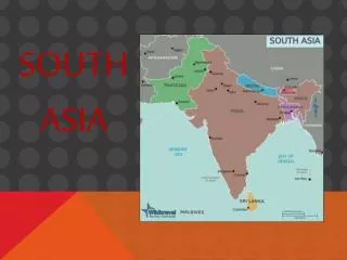
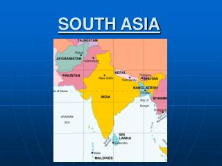
South Asia. http://www.vbmap.org/asia-maps-7/south-asia-political-map-91/. Chapter 24: Physical Geography of South Asia: The Land Where Continents Collided.

E N D
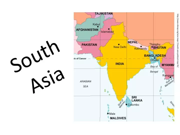
South Asia http://www.vbmap.org/asia-maps-7/south-asia-political-map-91/
Chapter 24: Physical Geography of South Asia: The Land Where Continents Collided • South Asia’s major landforms, including the massive Himalayan Mountains, were created when the subcontinent broke off from Africa and drifted into Asia. • Section 1: Landforms and Resources • Section 2: Climate and Vegetation • Section 3: Human-Environment Interaction • Section 1: Landforms and Resources • South Asia is a subcontinent of peninsulas bordered by mountains and oceans. • A wide variety of natural resources helps sustain life in the region.
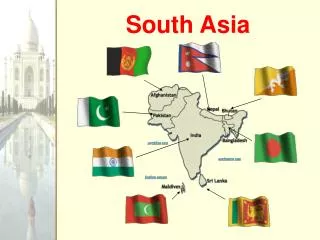
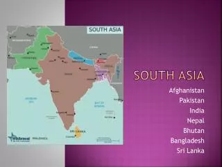
Mountains and Plateaus The Indian Subcontinent • India, Pakistan, Bangladesh, Bhutan, Nepal, Sri Lanka, the Maldives • Subcontinent—large landmass that’s smaller than a continent • called Indian Subcontinent because India dominates the region • Though half the size of U.S., area has 1/5 of world’s people • Natural barriers separate subcontinent from rest of Asia • mountains form northern border, Indian Ocean surrounds rest • Arabian Sea to west, Bay of Bengal to east
Northern Mountains • South Asia was once part of East Africa • split off 50 million years ago and collided with Central Asia • collision of tectonic plates pushed land into huge mountain ranges • Himalaya Mountains—1,500 mile-long system of parallel ranges • include world’s tallest mountain—Mt. Everest • form barrier between Indian subcontinent and China kingdoms of Nepal, Bhutan are also in these mountainsNorthern Mountains • At west end, Hindu Kush mountains separate Pakistan, Afghanistan • historically blocked invasions from Central Asian tribes • Khyber Pass is one of the major land routes through the mountains • Karakoram Mountains are in northeastern part of Himalayas • include world’s second highest peak, K2
Southern Plateaus • Tectonic plate collision also created smaller mountain ranges • Vindhya Rang in central India • Deccan Plateau covers much of southern India • Western, Eastern Ghats: mountain ranges flank Deccan Plateau • block moist winds and rain, making Deccan mostly arid
Rivers, Deltas, and Plains Great Rivers • Northern Indian, or Indo-Gangetic, Plain: • lies between Deccan Plateau, northern mountain ranges • is formed by three river systems that originate in Himalayas • Indus River flows west, then south through Pakistan to Arabian Sea • Ganges River flows east across northern India • Brahmaputra winds east, then west, south through Bangladesh • Ganges and Bramaputra meet, form delta, flow into Bay of Bengal
Fertile Plains • Rivers irrigate farmlands, carry rich alluvial soil • overflow deposits this soil on alluvial plains—rich farmlands • Indo-Gangetic Plain has some of the world’s most fertile farms • Heavily populated area has 3/5 of India’s people • area’s big cities: New Delhi, Kolkata in India; Dakha in Bangladesh • Plain is drier to west between Indus, Ganges • The Thar, or Great Indian Desert, lies to the south
Offshore Islands Sri Lanka: The Subcontinent’s “Tear Drop” • Island in Indian Ocean, off India’s southeastern tip • Large, tear-shaped country with lush tropical land • Range of high, rugged, 8,000-foot mountains dominate center • Many small rivers flow from mountains down to lowlands • Northern side has low hills, rolling farmland • Island is circled by coastal plain, long palm-fringed beaches
The Maldives Archipelago • Maldives is archipelago—island group—of 1,200 small islands • stretch north to south for 500 miles off Indian coast, near equator • Islands are atolls—low-lying tops of submerged volcanoes • surrounded by coral reefs, shallow lagoons • Total land area of Maldives is 115 square miles • only 200 islands are inhabited http://www.travel-visit-places.com/en/maldives/
Natural Resources Water and Soil • Water and soil resources provide food through farming, fishing • River systems help enrich land with alluvial soil, water • large- and small-scale irrigation projects divert water to farmlands • Types of fish include mackerel, sardines, carp, catfish • Waters provide transportation, power • India, Pakistan work to harness hydroelectric power
Forests • Indian rain forests produce hardwoods like sal and teak • also bamboo and fragrant sandalwood • Bhutan’s and Nepal’s highland forests have pine, fir, softwoods • Deforestation is a severe problem • causes soil erosion, flooding, landslides, loss of wildlife habitats • overcutting has devastated forests in India, Bangladesh, Sri Lanka
Minerals • India is fourth in world in coal production, has petroleum, uranium • Pakistan, Bangladesh have natural gas resources • Iron ore from India’s Deccan Plateau used in steel industry, exported • Other minerals: manganese, gypsum, chromium, bauxite, copper • India has mica for electrical equipment and growing computer industry • India is known for diamonds; Sri Lanka for sapphires, rubies
Section 2: Climate and Vegetation • Climate conditions in South Asia range from frigid cold in the high mountains to intense heat in the deserts. • Seasonal winds affect both the climate and vegetation of South Asia. Climate Zones • Cold highland zone in Himalayas, other northern mountains • Humid subtropical in foothills (Nepal, Bhutan), Indo-Gangetic Plain • Semiarid zone of west Plain, Deccan Plateau is warm with light rain • Desert zone covers lower Indus Valley, west India, south Pakistan • Thar Desert is driest area, with 10 inches of rain annually • Tropical wet zone in Sri Lanka and coasts of India, Bangladesh • Cherrapunji, India, holds rainfall record—366 inches in one month Climate—Wet and Dry, Hot and Cold
Monsoons and Cyclones • Monsoons—seasonal winds that affect entire region • dry winds blow from northeast October–February • moist ocean winds blow from southwest June–September • moist winds bring heavy rainfall, especially in southwest, Ganges Delta • unpredictable; cause hardship in lowlands of India, Bangladesh • Cyclone—violent storm with fierce winds, heavy rain • in Bangladesh low coastal region swamped by high waves
Vegetation: Desert to Rain Forest Vegetation Zones • Forested tropical wet zone in India’s west coast, south Bangladesh • lush rain forests of teak, ebony, bamboo • Highland forests of pine, fir in north India, Nepal, Bhutan • Humid subtropical river valleys; foothills have sal, oak, chestnut • Less vegetation in semiarid areas; desert shrubs, grasses • Deccan Plateau, Thar Desert • Sri Lanka’s tropical wet and dry climate produces grasses, trees
Section 3: Human-Environment InteractionRivers play a central role in the lives of South Asians, but water pollution and flooding pose great challenges to South Asian countries. Mother Ganges • Ganges is the best-known South Asian river • it’s shorter than the Indus, Brahmaputra • flows 1,500 miles from Himalayan glacier to Bay of Bengal • drains area three times France; home to 350 million people • Provides drinking and farming water, transportation • Known as Gangamai—“Mother Ganges” • becomes the Padma where it meets the Brahmaputra Living Along the Ganges
A Sacred River • Hinduismis the religion of most Indians • To Hindus, the Ganges Riveris the sacred home of the goddess Ganga • Hindus believe waters have healing powers; temples line its banks • pilgrims come to bathe, scatter ashes of dead • at sacred site of Varanasi they gather daily for prayer, purification • float baskets of flowers, burning candles on water
A Polluted River • Centuries of use have made Ganges most polluted river in world • sewage, industrial waste, human bodies poison the water • users get stomach and intestinal diseases, hepatitis, typhoid, cholera • In 1986, government plans sewage treatment plants, regulations • today few plants are operational, factories still dump waste • Clean up will take time, money, a change in how people see river http://in.reuters.com/article/2007/09/16/idINIndia-29492620070916
Controlling the FeniRiver A River Overflows • Feni River flows from Chittagong Hills to Bay of Bengal • Wide, slow-moving river flows through low-lying coastal plain • flat, marshy area floods during wet season due to monsoon rains • Cyclones bring storm surges—high waters that swamp low areas • sea water surges up river into flatlands, flooding villages • In 1980s, Bangladesh builds earthen dam over river’s mile-wide mouth
Using People Power • Bangladesh uses large population’s unskilled workers to build dam • Use cheap materials, low-tech process • lay bamboo mats, weight with boulders, cover with bags of clay • Build partial closure, then close Feni completely February 28, 1985 • when tide goes out 15,000 workers fill gaps with 600,000 bags • seven hours later the dam is closed
Completing the Dam • Dump trucks, earthmovers raise clay dam to height of 30 feet • put concrete, brick over sides, build road on top • South Asia’s largest estuary—arm of sea at river’s lower end—dam • Dam holds against cyclones and storm surges • villages and lands are protected
Chapter 25: Human Geography of South Asia: A Region of Contrasts • Both South Asia’s rich and ancient history, and its religious and ethnic diversity, have strongly shaped and defined its people’s lives. • Section 1: India • Section 2: Pakistan and Bangladesh • Section 3: Nepal and Bhutan • Section 4: Sri Lanka and the Maldives
Section 1: India • India is the largest country in South Asia and has the most developed economy. • Indian culture is deeply influenced by religion.
Invasions, Empires, and Independence Early History • Indian civilization begins in Indus Valley in 2500 B.C. • Aryans from north of Iran invade in 1500 B.C. • establish kingdoms on Ganges Plain, push Dravidians south • Persians, Greeks later invade Indus Valley • Mauryan Empire unites India in 321 B.C.; Asoka spreads Buddhism • Gupta Empire later rules northern India • Muslim Mughal Empirerules much of India by early 1500s
Europeans Arrive • In 1500s, French, Dutch, Portuguese build cloth, spice trades • British East India Company controls Indian trade by 1757 • British establish direct rule in 1857 • Raj—90-year period of direct British control, opposed by most Indians • Mohandas Gandhi’s nonviolent resistanceachieves goals peacefully • India gains its independence from Britain in 1947 • Muslim Pakistan splits from Hindu India; violence, migrations result
Governing the World’s Largest Democracy India After Independence • Constitution is created under first prime minister, Jawaharlal Nehru • a democratic republic since 1950 • System has federation of states, strong central government, like U.S. • Parliamentary system, like U.K. • India is mostly Hindu, but with large Muslim, Sikh, Tamil minorities • Sikhs kill Gandhi’s daughter, Prime Minister Indira Gandhi, 1984 • Tamils assassinate her son, Prime Minister Rajiv Gandhi, 1991
Economic Challenges Dependence on Farming • India has large economy, but half its people live in poverty • Two-thirds of people farm; most farms are small with low crop yields • Land reform—more balanced distribution of land among farmers • 5 percent of farm families own 25 percent of farmland • land-reform proposals make little progress • After famines of 1960s, scientists improve farm techniques, crops • Green Revolutionincreases crop yields for wheat, rice
Growing Industry • Cotton textiles have long been a major product • iron, steel, chemical, food industries develop after 1940s • Main industrial regions include: • Kolkata (Calcutta), Ahmadabad, Chennai (Madras), Delhi • Mumbai (Bombay) is India’s most prosperous city • a commercial center which produces metals, chemicals, electronics • Bangalore is the high-tech center, home to software companies
Life in Modern India Education • Indian economy is changing; more people work in factories, offices • Education is key to change, most middle-class kids go to school • Literacy has risen steadily since the 1950s • In slums and rural areas, school attendance, literacy still low
Indian Culture Many Languages • Constitution recognizes 18 major languages • India has over 1,000 languages and dialects • Hindi is the official language, but English is widely used by government, business workers
Hinduism • 80% of Indians are Hindu; complex Aryan religion includes many gods • reincarnation—rebirth of the soul after death • Original Aryan caste systemof social classes: • Brahmans—priests, scholars; Kshatriyas—rulers, warriors • Vaisyas—farmers, merchants; Sudras—artisans, laborers • Dalits(untouchables) are outside caste system—lowest status • Dharma is a caste’s moral duty; only reincarnation changes caste
Other Religions • India’s other faiths include Jainism, Christianity, Sikhism, Buddhism • Buddhism originated in northern India, but Islam is still strong in certain parts of India • Millions of Muslims left after 1947 independence
Section 2: Pakistan and Bangladesh • Pakistan and Bangladesh are Muslim countries formed as a result of the partition of British India. • Both Pakistan and Bangladesh have large populations and face great economic challenges.
New Countries, Ancient Lands Early History • Indus Valley civilization—largest of early civilizations • arises around 2500 B.C. in what is now Pakistan • Civilization falls around 1500 B.C.; Aryans invade soon after • Mauryan, Gupta, Mughal empires all rule entire region • Area is then ruled by British Empire until 1947
Partition and War • 1947 partitioncreates Hindu India, Muslim Pakistan • Hindu-Muslim violence killed one million people • 10 million crossed borders: Hindus to India, Muslims to Pakistan • Ethnic differences led to civil war between West and East Pakistan • East Pakistan won independence in 1971, became Bangladesh
Struggling Economies Subsistence Farming • Rapidly growing populations, low per capita income in both countries • Small plots farmed with old methods struggle to feed families • Climate hurts yields: arid Pakistan, Bangladesh, stormy • Pakistan’s irrigated Indus Valley grows wheat, cotton, rice • Bangladesh’s deltas produce rice, jute (used for rope, carpets) • freshwater fishing is also vital to economy
Small Industry • Neither country is highly industrialized • small factories lack capital, resources, markets to expand • Both export cotton clothes; Pakistan exports wool, leather goods • Microcreditpolicy allows small loans to poor entrepreneurs • entrepreneurs—people who start and build businesses • small businesses join together to get microloans
One Religion, Many Peoples Islamic Culture • Customs include daily prayer • Ramadan—month of fasting from sunrise to sunset • Pakistan’s stricter Islamic law includes purdah—women’s seclusion • women have no contact with men they are not related to, must wear veils in public • Bangladesh’s religious practices are less strict
Ethnic Diversity • Pakistan is more diverse: five main groups, each with own language • Punjabis, Sindhis, Pathans, Muhajirs, Balochs • Punjabis are half the population, Muhajirs left India in 1947 • national language is Muhajirs’ Urdu • Majority of people in Bangladesh are Bengali • Bengali language based on Sanskit, ancient Indo-Aryan language
Section 3: Nepal and Bhutan • Nepal and Bhutan are landlocked Himalayan kingdoms. • Rugged terrain and an isolated location have had a great impact on life in Nepal and Bhutan.
Mountain Kingdoms Geographic Isolation • Both countries are located in Himalayas; each has: • central upland of ridges, valleys leading to high mountains • small lowland area along Indian border • Mountain landscape isolates Nepal, Bhutan: hard to reach, conquer • China controlled Bhutan briefly in 18th century • Both remained mostly independent, rarely visited by foreigners
Evolving Monarchies • In past, both countries split into religious kingdoms, ruling states • Unified kingdoms emerge, led by hereditary monarchs • Today both are constitutional monarchies • kingdoms where ruler’s power is limited by constitution • Bhutan’s king is supreme ruler, Nepal’s shares power with parliament
Developing Economies Limited Resources • Both countries are poor: agricultural economies, but little farmland • mountainous terrain, poor soil, erosion • terraced farms grow rice, corn, potatoes, wheat • livestock include cattle, sheep, yaks • Timber industry is important, but has led to deforestation
Developing Economies Increasing Tourism • Tourism is fastest-growing industry in Nepal • people visit capital at Kathmandu, climb Himalayas • hotels, restaurants, services grow but tourism also hurts Nepal’s environment; trash left on mountains • • Bhutan regulates, limits tourism, keeps some areas off-limits
Rich Cultural Traditions A Mix of People • Nepal’s Indo-Nepalese, Hindu majority came from India centuries ago • speak Nepali, variation of Sanskrit • Nepal also has groups of Tibetan ancestry, including Sherpas • high-Himalayan people; traditional mountain guides of Everest area • Bhutan’s main ethnic group is the Bhote, who trace origins to Tibet
Religious Customs • Siddhartha Gutama, the Buddha, born in 500s B.C. • Nepalese were Buddhist; today most are Hindu • Tibetan-style Buddhism is official religion of Bhutan • uses mandalas—symbolic geometric designs for meditation
Section 4: Sri Lanka and the Maldives • Sri Lanka and the Maldives are island countries with strong connections to the South Asian subcontinent. • Sri Lanka and the Maldives face difficult challenges that affect their political and economic development.
History of the Islands Settlement of Sri Lanka • In 500s B.C. Indians cross strait to Sri Lanka, become Sinhalese • In A.D. 300s, Tamils—Indian Dravidian Hindus—settle in north end • Portuguese, Dutch come in 1500s; British rule in 1796, call it Ceylon • island gains independence in 1948, becomes Sri Lanka in 1972
A Muslim State in the Maldives • Buddhists, Hindus from India, Sri Lanka settle islands in 500s B.C. • Arab traders visit often, population converts to Islam by 1100s • Governed by six dynasties of Muslim sultans—rulers • Declares itself a republic in 1968, headed by elected president • 1,200 islands; a land area of 115 square miles; population 300,000 • one of the world’s smallest independent country
Life in the Islands Cultural Life in Sri Lanka • Buddhist, Hindu temples, Muslim mosques dot landscape • art, literature strongly influenced by religions Cultural Life in the Maldives • Culture is strongly influenced by Muslim customs • Islam is state religion—no others allowed