Download
1 / 29
290 likes | 416 Views
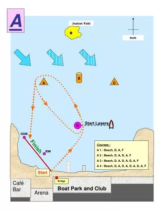
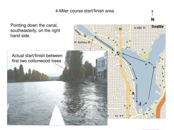
4-Miler course start/finish area. N. Pointing down the canal, southeasterly, on the right hand side. Actual start/finish between first two cottonwood trees. Approaching first bridge (1000 meters). Careful as waterway narrows for bridge abutments. Entering Lake Union.

E N D
4-Miler course start/finish area N Pointing down the canal, southeasterly, on the right hand side. Actual start/finish between first two cottonwood trees
Approaching first bridge (1000 meters) Careful as waterway narrows for bridge abutments
Entering Lake Union Approaching first turn (right)
Entering Lake Union Check out the wind direction and velocity on this windsock. This will affect water conditions appropriately.
Heading south on Lake Union Looking toward downtown
Speed Buoys Two of these buoys are to your immediate left at this point
Approaching the south end AGC Building. Gold letters clearly visible.
Approaching the south end Large red “can” buoy now becoming visible. It is immediately opposite the AGC building
Approaching the south end turn Red buoy fully visible, but don’t initiate your turn too soon.
In the south end (left hand) turn Approach the red buoy passing to the right of it
In the south end turn This is the apex (farthest point) of the south end turn – view is on the port side looking north
Ending the south end turn Still viewing the buoy on your port side but your bow will be pointing north
Heading to the north turn There is a single white apartment building that is built over the water, aim generally towards it or between the only two tall buildings visible
Heading to the north turn It is a straight shot to the north turn, do NOT follow the circumference of the lake at the south end
Heading to the north turn As you get closer you’ll start steering slightly left of the apartments and the tall buildings to set up for the turn
Heading to the north turn Note on the way into this area you’ll be passing two more small yellow speed buoys on your port side. Note also that the commercial waterway traffic like this has the right of way. You will be crossing the traffic pattern in this turn.
Heading into the north turn The beginning of the north turn is marked by this sailboat dock (note masts) that protrudes out farther than any other dock. White sign on the end of it.
Heading into the north turn At this point you can start turning towards the right side of the green metal “can” buoy at the north end by Gasworks Park.
Beginning the north turn The sign
In the north turn This is one of the most hazardous portions, make sure you yield if necessary as you are crossing the traffic pattern.
In the north turn Pass to the right of the green buoy, between it and the Gasworks wall.
Completing the north turn Passing the buoy is the end of the north turn, you should be pointed appropriately once you pass it and heading straight towards the bridge opening. The powerline tower is a good object to point towards AFTER you pass the buoy.
Exiting the north turn From here it is a straight shot to the canal opening but aim for the smaller draw bridge or powerline tower
Approaching the bridges Do NOT follow the contour of the waterway here, it opens up to the right. If you do, you will row farther and potentially collide with club rowers launching from LWRC docks.
Through the bridges Careful as it narrows significantly here. Watch the canal wall on the right but stay on the right side under the bridge. Bridge/waterway centerline
Into the canal View from under the bridge. 1000 meters to go. It opens up a bit so move to the right side of the waterway. Note the powerline tower alignment
500 Meters to go This flag is off port side and it is the 500 meter mark.
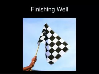
Nearing the finish The finish, same as the start, is the last two large cottonwood trees near the SPU dock. There should be a flagger.
The finish As always, stay to the right, and row through the finish, do NOT stop until the entire boat is well past the line. DO NOT impede finishers behind you, row on. Start/Finish line Racing traffic! Do NOT stop here Finishing traffic