Download
1 / 24
280 likes | 558 Views
Michael Pearlman 1 , Georg Kirchner 2 , Werner Gurtner 3 , Erricos Pavlis 4 , and Carey Noll 5

E N D
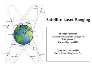
Michael Pearlman 1, Georg Kirchner 2, Werner Gurtner 3, Erricos Pavlis 4, and Carey Noll 5 1 Harvard-Smithsonian Center for Astrophysics, Cambridge MA USA2 Austrian Academy of Sciences, Graz, Austria3 Universität Bern Astronomisches Institut, , Bern, Switzerland4 Joint Center for Earth Systems Technology, Baltimore, MD, USA5 NASA Goddard Space Flight Center, Greenbelt MD, USA Satellite Laser Ranging and Its Impact on WEGENER
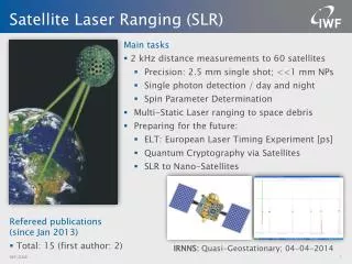
Satellite Laser Ranging Technique Precise range measurement between an SLR ground station and a retroreflector- equipped satellite using ultrashort laser pulses corrected for refraction, satellite center of mass, and the internal delay of the ranging machine. • Simple range measurement • Space segment is passive • Simple refraction model • Night / Day Operation • Near real-time global data availability • Satellite altitudes from 400 km to 20,000 km (e.g. GPS/GLONASS), and the Moon • Cm satellite Orbit Accuracy • Able to see small changes by looking at long time series • Unambiguous centimeter accuracy orbits • Long-term stable time series
Established in 1984 with the WEGENER/MEDLAS activity Mobile SLR measurements of crustal motion around the Mediterranean region WEGENER (1/3) WEGENER SLR Occupations TLRS-1 MTLRS-1/2
Expanded in 1991 with the NRA Proposal (Kootwijk, March 1991) Improving the understanding of the interaction between the Afro-Arabian and Eurasian plates; Study the extent of the rebound phenomena in the Fennoscandia region; Make first assessment of the geodetically identifiable components of change contributing to mean sea level and develop improved techniques for modeling height variation using space space techniques. WEGENER (2/3)
WEGENER (3/3) • WEGENER/MEDLAS measured ground motions
WEGENER/MEDLAS GPS Measurements Noto, Italy Matera, Italy (photos courtesy of EUREF)
Measurements Precision Orbit Determination (POD) Time History of Station Positions and Motions Products Terrestrial Reference Frame (Center of Mass and Scale) Plate Tectonics and Crustal Deformation Static and Time-varying Gravity Field Earth Orientation and Rotation (Polar Motion, length of day) Precision Orbits and Calibration of Altimetry Missions (Oceans, Ice) Total Earth Mass Distribution Space Science - Tether Dynamics, etc. Lunar Science and Relativity More than 60 Space Missions Supported since 1970 Four Missions Rescued in the Last Decade SLR Science and Applications
ILRS Network • 33 global stations providing tracking data regularly • Majority of SLR stations co-located with GNSS
Selected SLR Stations Around the World Zimmerwald, Switzerland Shanghai, China NGSLR, Greenbelt, MD USA Matera, Italy MLRS, TX USA Kashima, Japan Riyadh, Saudi Arabia TROS, China Wettzell, Germany Tahiti, French Polynesia TIGO, Concepcion, Chile Yarragadee, Australia Hartebeesthoek, South Africa
Sample of SLR Satellite Constellation(Geodetic Satellites) Etalon-I & -II LAGEOS-2 LAGEOS-1 Starlette Stella GFZ-1 Ajisai
Sample of SLR Satellite Constellation(POD Support) Terra-SAR-X CHAMP ERS-1 GFO-1 ERS-2 Meteor-3M Jason-1 Envisat GRACE ANDE
Sample of SLR Satellite Constellation(HEO) COMPASS GLONASS GIOVE ETS-8 GPS
GPS Tracking Campaign(25-Mar-2008 through 26-May-2008) 33 Passes/week
Established in 1998 as a service under the International Association of Geodesy (IAG) ILRS collects, merges, analyzes, archives and distributes satellite and lunar laser ranging data to satisfy a variety of scientific, engineering, and operational needs and encourages the application of new technologies to enhance the quality, quantity, and cost effectiveness of its data products Components Tracking Stations and Subnetworks Operations Centers Global and Regional Data Centers Analysis and Associate Analysis Centers Central Bureau ILRS produces standard products for the scientific and applications communities International Laser Ranging Service (ILRS)
2 kHz operation to increase data yield; Automation and autonomous tracking to increase tracking coverage; Pass interleaving techniques to improves acquisition efficiency; Eye-safe operations for safety during autonomous operations; Event timers with near-ps resolution for higher accuracy; Web based restricted tracking to protect optically vulnerable satellites (ICESat, ALOS, etc.) Two wavelength experiments to test refraction models; Hollow retroreflector cubes for lighter, higher efficiency arrays; Experiments to demonstrate optical transponders for interplanetary ranging Technology Developments
LAGEOS Pass from Graz Station High repetition rate, short pulse lasers allow us to see retroreflector array details
Pass Interleaving Pass interleaving allows stations to track satellites that are simultaneously visible
NASA SLR Systems NASA’s Next Generation SLR (NGSLR), GGAO, Greenbelt, MD
Better designed arrays with uncoated cubes now being placed on high satellites Several stations now ranging to ETS-8 in synchronous orbit; Much improved results on COMPASS; Hollow cube technology for space now being developed (GSFC and Laboratori Nazionali di Frascati, LNF, Italy); Dialog underway with relevant agencies on the importance of including reflectors on GPS-III satellites Retroreflector Technology Single hollow cube Hollow cube array configuration
ILRS “official products” (station coordinates and EOP) issued weekly; Seven ILRS Analysis Centers contribute to the official products: ASI, Agenzia Spaziale Italiana BKG, Bundesamt für Kartographie und Geodäsie DGFI, Deutsches Geodätisches Forschungsinstitut GA, Geosciences Australia GFZ, GeoForschungsZentrum Potsdam JCET, Joint Center for Earth Systems Technology NSGF, NERC Space Geodesy Facility GRGS, Groupe de Recherches de Geodesie Speciale Combination and Combination Back-up Centers at ASI and DGFI compute the combination products and furnish them to the IERS Time series of weekly solutions is provided to the IERS for the development of the ITRF; Analysis of early LAGEOS (1976-1993) data underway for ILRS product submission to the next reference frame; New “official POD product” for geodetic satellites under development Analysis Activities
Geocenter Motion • mm-level Geodesy requires understanding of the reference frame and its distortions to acute levels of precision. • Shown here is the change in the origin of the crust-fixed frame w.r.t. the center of mass due to non tidal mass transport in the atmospheric and hydrospheric systems.
Gravity changes from SLR showinglong-wavelength water redistribution Large interannual variations related to strong El-Niño-Southern Oscilation (ENSO) events seasonal variation only From Cheng and Tapley (2004) Seasonal variation from mass redistribution in atmosphere, ocean and continental water
Multi-year gravity changes from SLR(seasonal variation removed) Cheng and Tapley (2004) Secular trend significantly affected if time series is not long enough Cox and Chao (2002)