Download
1 / 1
10 likes | 149 Views
Estimating Thermal Energy Emission and Eruption Rates at Guatemalan Volcanoes Using Thermal Data From a FLIR Camera, ASTER, and MODIS Data Sources Luke Bowman, Lara Kapelanczyk, Anna Colvin, Otoniel Matías, W.I. Rose, Miriam Rios-Sánchez, R ü diger Escobar-Wolf

E N D
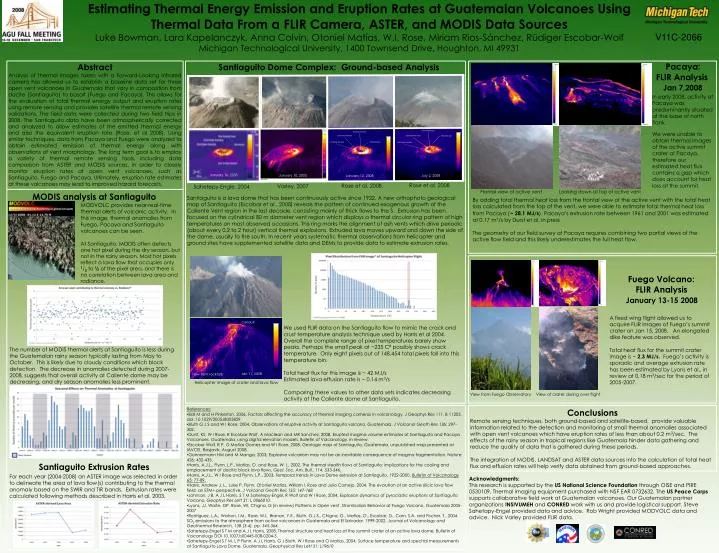
Estimating Thermal Energy Emission and Eruption Rates at Guatemalan Volcanoes Using Thermal Data From a FLIR Camera, ASTER, and MODIS Data Sources Luke Bowman, Lara Kapelanczyk, Anna Colvin, Otoniel Matías, W.I. Rose, Miriam Rios-Sánchez, Rüdiger Escobar-Wolf Michigan Technological University, 1400 Townsend Drive, Houghton, MI 49931 V11C-2066 150°C Hot Central Core Hot Central Core 150 °C Cool Inner Annulus 150 °C Cool Inner Annulus Discontinuity Hot Outer Annulus Discontinuity Hot Outer Annulus Pacaya: FLIR Analysis Jan 7,2008 Abstract Analysis of thermal images taken with a Forward-Looking Infrared camera has allowed us to establish a baseline data set for three open vent volcanoes in Guatemala that vary in composition from dacite (Santiaguito) to basalt (Fuego and Pacaya). This allows for the evaluation of total thermal energy output and eruption rates using remote sensing and provides satellite thermal remote sensing validations. The field data were collected during two field trips in 2008. The Santiaguito data have been atmospherically corrected and analyzed to allow estimates of the emitted thermal energy and also the equivalent eruption rate (Rose, et al 2008). Using similar techniques, data from Pacaya and Fuego were analyzed to obtain estimated emission of thermal energy along with observations of vent morphology. The long term goal is to employ a variety of thermal remote sensing tools, including data comparison from ASTER and MODIS sources, in order to closely monitor eruption rates at open vent volcanoes, such as Santiaguito, Fuego and Pacaya. Ultimately, eruption rate estimates at these volcanoes may lead to improved hazard forecasts. Santiaguito is a lava dome that has been continuously active since 1922. A new orthophoto geological map of Santiaguito (Escobar et al., 2008) reveals the pattern of continued exogenous growth of the Caliente Vent region in the last decade, consisting mainly of thick flows to the S. Extrusion has been focused on the cylindrical 80 m diameter vent region which displays a thermal circular ring pattern of high temperatures on most observed occasions. This ring marks the alignment of ash vents which drive periodic (about every 0.2 to 2 hour) vertical thermal explosions. Extruded lava moves upward and down the side of the dome, usually to the south. In recent years systematic thermal observations from helicopter and ground sites have supplemented satellite data and DEMs to provide data to estimate extrusion rates. Santiaguito Dome Complex: Ground-based Analysis N W E Rainy Season 0°C 0 °C S 0 °C In early 2008, activity at Pacaya was predominantly situated at the base of north flank. Heat Flux ~ 20.8 MJ/s Heat Flux ~ 7.2 MJ/s We were unable to obtain thermal images of the active summit crater at Pacaya, therefore our estimated heat flux contains a gap which does account for heat loss at the summit. January 16, 2005 January 10, 2005 January 12, 2008 July 2, 2008 Rose et al, 2008 Rose et al, 2008 Varley, 2007 Sahetepy-Engle, 2004 Frontal view of active vent Looking down at top of active vent MODIS analysis at Santiaguito By adding total thermal heat loss from the frontal view of the active vent with the total heat loss calculated from the top of the vent, we were able to estimate total thermal heat loss from Pacaya (~28.1 MJ/s). Pacaya’s extrusion rate between 1961 and 2001 was estimated at 0.17 m3/s by Durst et al. in press The geometry of our field survey at Pacaya requires combining two partial views of the active flow field and this likely underestimates the full heat flow. MODVOLC provides near-real-time thermal alerts of volcanic activity. In this image, thermal anomalies from Fuego, Pacaya and Santiaguito volcanoes can be seen. At Santiaguito, MODIS often detects one hot pixel during the dry season, but not in the rainy season. Most hot pixels reflect a lava flow that occupies only 1/3 to ½ of the pixel area, and there is no correlation between lava area and radiance. January 13, 2008 January 15, 2008 Fuego Volcano: FLIR Analysis January 13-15 2008 A fixed wing flight allowed us to acquire FLIR images of Fuego’s summit crater on Jan 15, 2008. An elongated dike feature was observed. Total heat flux for the summit crater image is ~ 2.3 MJ/s. Fuego’s activity is sporadic and average extrusion rate has been estimated by Lyons et al., in review at 0.18 m3/sec for the period of 2005-2007. conduit We used FLIR data on the Santiaguito flow to mimic the crack and crust temperature analysis technique used by Harris et al 2004. Overall the complete range of pixel temperatures barely show peaks. Perhaps the small peak at ~235 C⁰ possibly shows crack temperature. Only eight pixels out of 148,454 total pixels fall into this temperature bin. Total heat flux for this image is ~ 42 MJ/s Estimated lava effusion rate is ~ 0.14 m3/s Comparing these values to other data sets indicates decreasing activity at the Caliente dome at Santiaguito. The number of MODIS thermal alerts at Santiaguito is less during the Guatemalan rainy season typically lasting from May to October. This is likely due to cloudy conditions which block detection. The decrease in anomalies detected during 2007-2008, suggests that overall activity at Caliente dome may be decreasing, and dry season anomalies less prominent. Jan 11, 2008 Flow front rockfalls Helicopter image of crater and lava flow Acknowledgments: This research is supported by the US National Science Foundation through OISE and PIRE 0530109. Thermal imaging equipment purchased with NSF EAR 0732632. The US Peace Corps supports collaborative field work at Guatemalan volcanoes. Our Guatemalan partner organizations INSIVUMEH and CONRED work with us and provide logistical support. Steve Sahetapy-Engel provided data and advice. Rob Wright provided MODVOLC data and advice. Nick Varley provided FLIR data. View from Fuego Observatory View of crater during over flight • References: • Ball M and H Pinkerton, 2006, Factors affecting the accuracy of thermal imaging cameras in volcanology, J Geophys Res 111, B 11203, doi: 10.1029/2005JB003829. • Bluth G J S and W I Rose, 2004, Observations of eruptive activity at Santiaguito volcano, Guatemala, J Volcanol Geoth Res 136: 297-302. • Durst, KS, W I Rose, R Escobar-Wolf, A Maclean and MR Sanchez, 2008, Erupted magma volume estimates at Santiaguito and Pacaya Volcanoes, Guatemala, using digital elevation models, Bulletin of Volcanology, in review. • Escobar Wolf, R P, O Matías Gomez and W I Rose, 2008, Geologic map of Santiaguito, Guatemala, unpublished map presented at IAVCEI, Reyjavik, August 2008. • Gonnermann HM and M Manga, 2003, Explosive volcanism may not be an inevitable consequence of magma fragmentation, Nature 426: 432-435. • Harris, A.J.L., Flynn, L.P., Matías, O. and Rose, W. I., 2002, The thermal stealth flows of Santiaguito: implications for the cooling and emplacement of dacitic block lava flows, Geol. Soc. Am. Bull., 114: 533-546. • Harris, A.J.L., W I Rose and Flynn, L.P., 2003, Temporal trends in Lava Dome extrusion at Santiaguito, 1922-2000, Bulletin of Volcanology 65: 77-89. • Harris, Andrew J. L., Luke P. Flynn, Otoniel Matías, William I. Rose and Julio Cornejo, 2004, The evolution of an active silicic lava flow field: an ETM+ perspective, J Volcanol Geoth Res 135: 147-168 • Johnson, J B, A J L Harris, S T M Sahetepy-Engel, R Wolf and W I Rose, 2004, Explosion dynamics of pyroclastic eruptions at Santiaguito Volcano, Geophys Res Lett 31: L 0066010. • Lyons, JJ, Waite, GP, Rose, WI, Chigna, G (in review) Patterns in Open vent, Strombolian Behavior at Fuego Volcano, Guatemala 2005-2007 • Rodríguez, L.A., Watson, I.M., Rose, W.I., Branan, Y.K., Bluth, G.J.S., Chigna, G., Matías, O., Escobar, D., Carn, S.A. and Fischer, T., 2004, SO2 emissions to the atmosphere from active volcanoes in Guatemala and El Salvador, 1999-2002, Journal of Volcanology and Geothermal Research, 138 (3-4), pp. 345-364. • Sahetepy-Engel S T M and A J L Harris, 2008, Thermal structure and heat loss at the summit crater of an active lava dome, Bulletin of Volcanology DOI 10.1007/s00445-008-0204-3 • Sahetepy-Engel S T M, L P Flynn, A J L Harris, G J Bluth, W I Rose and O Matías, 2004, Surface temperature and spectral measurements at Santiaguito Lava Dome, Guatemala, Geophysical Res Lett 31: L19610 Conclusions Remote sensing techniques, both ground-based and satellite-based, provide valuable information related to the detection and monitoring of small thermal anomalies associated with open vent volcanoes which have eruption rates of less than about 0.2 m3/sec. The effects of the rainy season in tropical regions like Guatemala hinder data gathering and reduce the quality of data that is gathered during these periods. The integration of MODIS, LANDSAT and ASTER data sources into the calculation of total heat flux and effusion rates will help verify data obtained from ground-based approaches. Santiaguito Extrusion Rates For each year (2004-2008) an ASTER image was selected in order to delineate the area of lava flow(s) contributing to the thermal anomaly based on the SWIR and TIR bands. Extrusion rates were calculated following methods described in Harris et al, 2003.