Download
1 / 20
200 likes | 206 Views
MBMG Data Center and Collaborative Science. Presented to 2018 AWRA Conference Luke Buckley. Introduction and Outline. Surface Water Assessment and Monitoring Program (SWAMP) MBMG Data Center Inward collaboration Outward collaboration Usefulness. http://mbmg.mtech.edu/datacenter.

E N D
MBMG Data Centerand Collaborative Science Presented to 2018 AWRA Conference Luke Buckley
Introduction and Outline • Surface Water Assessment and Monitoring Program (SWAMP) • MBMG Data Center • Inward collaboration • Outward collaboration • Usefulness
http://mbmg.mtech.edu/datacenter 24x7 access to all public MBMG data
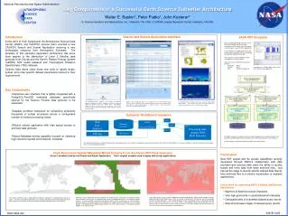
Surface Water Assessment and Monitoring Program (SWAMP) A tale of two agencies
Others DNRC MBMG AQUARIUS QAQC Manual Provisional Raw Validated Telemetry Legacy Private Public HARVESTER SWAMP MBMG Data Services Portal Mapper Tabular Flow Water Q Temp Public Internet Access GIS WEB Web Services
Collaborating through piloting County-level data • Lewis and Clark, Gallatin • Template-based data transfer • Web interface (data management) • Inclusion in Data Center
Overall usage of the SWAMP website has seen steady growth throughout 2017 Visitors 11,385 AverageActivity 5 actions Total Queries 119,558 Total Downloads 4,978,043,541
The SWAMP website is gaining a foothold on the Internet; over 90 different sites refer traffic Department of Natural Resources and Conservation Ucpress Bitterroot Water Forum Google University of Florida Fish, Wildlife, and Parks Lolo Watershed Group Outlook Baidu Yahoo Yandex Facebook Big Hole Watershed Committee Yale Nevada Creek Water User's Association Bing University of North Carolina National Weather Service Teton River Distribution Project
Going behind the curtain Websites Databases Internet Business Layers
Internal collaboration Drillers Drillers Consultants GWIC Projects Landowners IoT Law Government
MBMG Data Center Now AQUARIUS GWIC 1994 Analytics 1999 DrillerWeb 2003 Catalog 2003 Document Manager 2005 POS 2005 Coal 2006 AIM 2006 Quakes 2006 Data Preservation 2007 LISA/Lab 2009 Telemetry 2009 CKAN Surface Water 2010 NGDS 2011 GIS/SDE 2012 Staging 2013 Proppant 2013 SWAMP 2015 rocks It’s not my fault Geographic Information System
State and Local Collaborations • Department of Environmental Quality (DEQ) • Department of Natural Resources and Conservation (DNRC) • Water • Oil and Gas • Natural Resource Information System (NRIS) • Local Water Quality Districts • Missoula • Lewis and Clark • Gallatin • County Sanitarians
Other Portals In addition to our own websites, several other entities display our data through either direct links or through web services. Displayed are snapshots of the Montana Digital Atlas (NRIS), NGWMN Portal, Water Sage, and Ron Askin Drilling. NGWMN and Water Sage do periodic harvests from web services. NRIS does live access to web services. Askin Drilling uses and account-entry to GWIC. WaterSage
National Collaborations Federal Emergency Management Agency (FEMA) National Coal Resources Data System (NCRDS) National Geothermal Data System (NGDS) National Geological and Geophysical Data Preservation Program (NGGDPP) National Ground Water Monitoring Network (NGWMN)
The End Luke Buckley Associate Professor Montana Bureau of Mines and Geology Montana Technological University (406) 496-4677 LBuckley@mtech.edu