Download
1 / 131
1.31k likes | 1.33k Views
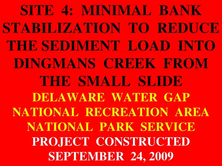
SITE 4: MINIMAL BANK STABILIZATION TO REDUCE THE SEDIMENT LOAD INTO DINGMANS CREEK FROM THE SMALL SLIDE DELAWARE WATER GAP NATIONAL RECREATION AREA NATIONAL PARK SERVICE PROJECT CONSTRUCTED SEPTEMBER 24, 2009.

E N D
SITE 4: MINIMAL BANK STABILIZATION TO REDUCE THE SEDIMENT LOAD INTO DINGMANS CREEK FROM THE SMALL SLIDEDELAWARE WATER GAP NATIONAL RECREATION AREA NATIONAL PARK SERVICE PROJECT CONSTRUCTED SEPTEMBER 24, 2009
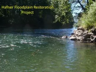
1 YEAR LATER-Mid-project Bendway Weirs, Traffic Control Stones, & vegged floodplain bench. 1 YEAR LATER-DINGMANS CR.-SITE 4-PIX BY DERRICK 9-12-2010
1 YEAR LATER-Mid-project Bendway Weirs, Traffic Control Stones, & vegged floodplain bench. 1 YEAR LATER-DINGMANS CR.-SITE 4-PIX BY DERRICK 9-12-2010
PROBLEMS • For approximately 200 ft Dingmans Creek is flowing against & eroding the left valley wall (estimated height 35 ft). The amount of fine sediment delivered to the stream is significant. This entire colluvium slide is very unstable. If erosion progresses at this site it may kick the stream back toward the park road downstream and create a threat to road stability (Johnny B. Mountain Road). • The point bar (right side) of the channel is very rough with a number of boulders increasing the hydraulic roughness & impeding flow.
HIGH WATER-Looking US @ upper section of slide (most vertical section of slide). Thalweg delineated by turbulent flow (white water) PRE-PROJECT DINGMANS CR-SITE 4 PIX BY DERRICK 7-24-2008
HIGH WATER-Looking DS @ fast run into upper 1/3 of project. PRE-PROJECT DINGMANS CR-SITE 4 PIX BY DERRICK 7-24-2008
HIGH WATER-Looking DS @ middle of project. PRE-PROJECT DINGMANS CR-SITE 4 PIX BY DERRICK 7-24-2008
HIGH WATER-Looking across @ middle of project. Bank is approximately 35 to 40 ft tall, 200 ft long. PRE-PROJECT DINGMANS CR-SITE 4 PIX BY DERRICK 7-24-2008
HIGH WATER-Looking DS @ lower 1/3rd of project. Most material on slide is extremely loose & uncompacted. PRE-PROJECT DINGMANS CR-SITE 4 PIX BY DERRICK 7-24-2008
HIGH WATER-Looking DS @ lower section of project bank. PRE-PROJECT DINGMANS CR-SITE 4 PIX BY DERRICK 7-24-2008
HIGH WATER-Looking DS @ DS end of project. PRE-PROJECT DINGMANS CR-SITE 4 PIX BY DERRICK 7-24-2008
HIGH WATER-Looking DS @ lower end of project. Some herbaceous plants holding some colluvium in place. PRE-PROJECT DINGMANS CR-SITE 4 PIX BY DERRICK 7-24-2008
HIGH WATER-Looking DS @ steeper slope @ DS end. PRE-PROJECT DINGMANS CR-SITE 4 PIX BY DERRICK 7-24-2008
HIGH WATER-Looking DS @ point bar side of channel. This is a high flow relief area. Immediately to the right is a heavily vegetated alluvium berm (probably pushed up during previous channel clearing activities). PRE-PROJECT DINGMANS CR-SITE 4 PIX BY DERRICK 7-24-2008
PRE-PROJECT PHOTOSby Dave DerrickDec. 15, 2008 (HIGH WATER)LEAF OFF CONDITION
HIGH WATER-Looking US @ project bank. Stream is obviously eroding this bank, which contributes significant sediment to the system PRE-PROJECT DINGMANS CR-SITE 4 PIX BY DERRICK 12-15-2008
HIGH WATER-Looking across @ project bend. All colluvium pictured is loose & unconsolidated. PRE-PROJECT DINGMANS CR-SITE 4 PIX BY DERRICK 12-15-2008
HIGH WATER-Looking across @ project bend (left bank) PRE-PROJECT DINGMANS CR-SITE 4 PIX BY DERRICK 12-15-2008
HIGH WATER-Looking DS toward DS end of project. PRE-PROJECT DINGMANS CR-SITE 4 PIX BY DERRICK 12-15-2008
HIGH WATER-Looking DS @ exit conditions to project. Large Woody Debris is protecting a portion of the right bank. Right bank erosion is visible further downstream in the bend. PRE-PROJECT DINGMANS CR-SITE 4 PIX BY DERRICK 12-15-2008
Looking US @ entrance conditions into the Site 4 project. Mega-wall project is visible in the background. PRE-PROJECT DINGMANS CR-SITE 4 PIX BY DERRICK 9-9-2009
Looking @ eroded left bank, upper end of the project. PRE-PROJECT DINGMANS CR-SITE 4 PIX BY DERRICK 9-9-2009
Looking @ left bank. Bank is steepest in this area with a high rate of erosion. PRE-PROJECT DINGMANS CR-SITE 4 PIX BY DERRICK 9-9-2009
Looking @ left bank. Bank is steepest in this area. PRE-PROJECT DINGMANS CR-SITE 4 PIX BY DERRICK 9-9-2009
Looking DS. Toe of bank erodes, undermining existing vegetation. PRE-PROJECT DINGMANS CR-SITE 4 PIX BY DERRICK 9-9-2009
Looking DS @ the lower end of the project reach. Vegetation is deceiving as it is removed during high flow events. Note boulder roughness on right side of channel PRE-PROJECT DINGMANS CR-SITE 4 PIX BY DERRICK 9-9-2009
Looking across @ center of project reach. PRE-PROJECT DINGMANS CR-SITE 4 PIX BY DERRICK 9-9-2009
Looking US @ middle of project area. PRE-PROJECT DINGMANS CR-SITE 4 PIX BY DERRICK 9-9-2009
Looking DS @ lower portion of the project. PRE-PROJECT DINGMANS CR-SITE 4 PIX BY DERRICK 9-9-2009
Looking DS @ log jam @ DS end of project area. Bank slightly more stable as boulders deflect some energy. This function will be employed in our protection works. PRE-PROJECT DINGMANS CR-SITE 4 PIX BY DERRICK 9-9-2009
SOLUTIONS (THE PLAN) • This project is designed to stabilize 200 ft of the bank at the present location by increasing roughness of the entire bank with 3 gallon container rooted-stock trees & shrubs. • Hard protection is limited to the toe & includes 35 vegetated Traffic Control Stones (TCS). TCS were typically 3 ft by 3 ft by 4 ft & spaced 3 to 6 ft apart. Every 4th TCS was keyed 8 to 10’ into the bank & had a Single-Stone Bendway Weir (SSBW) placed at the stream end. Live poles were placed in the key trench before stone was placed. Eight SSBW were built. • A random natural bedload boulder field was placed around & in front of the SSBW & TCS’s.
Correction: There should be 3 Traffic Control Stones between each Single Stone Bendway Weir, not 2. Courtesy of Ecological Restoration, Inc.
TCS SSBW Key Courtesy of Ecological Restoration, Inc.
PLANTS PLANTED Common Name # Size • Gray Birch 50 2 gallon pots • Gray Birch 200 unrooted poles • Buttonbush 25 bare root • Silky Dogwood 200 bare root • Ninebark 175 bare root • Rhododendron 50 3 gallon pots • White Pine 150 3 gallon pots
METHODS EMPLOYED • 35 Vegetated Traffic Control Stones (TCS) • Every 4th TCS is keyed 10 ft into the bank (perpendicular) with rooted Black Willow whips & other live poles planted at a rate of 3 plants per ft. • Every 4th TCS has a Single Stone Bendway Weir (SSBW) to move the thalweg away from the left bank & toward the center of the channel approximately 5-8 ft. • The space between & behind the TCS is heavily vegetated with a variety of species of rooted-stock trees & shrubs. • The loose eroding talus slope slide was heavily planted with several species of rooted-stock shrubs & trees • Native boulders from the point bar were placed as a random boulder field streamward of the TCS & SSBW.
The Morooka, a way cool tracked dump truck. CONSTRUCTION DINGMANS CR-SITE 4 PIX BY DERRICK 9-19-2009
Sandbags to be used to cordon off work areas in the stream. CONSTRUCTION DINGMANS CR-SITE 4 PIX BY DERRICK 9-19-2009
A 8 ft by 14 ft polycarbonate mat to be used as a platform for the trackhoe to work over the active stream. CONSTRUCTION DINGMANS CR-SITE 4 PIX BY DERRICK 9-19-2009
Looking DS @ Dave Hails tiptoeing over large stone in the Cat 315c. CONSTRUCTION DINGMANS CR-SITE 4 PIX BY DERRICK 9-19-2009
Stockpiled large stone for Traffic Control Stones and Single Stone Bendway Weirs (1 in the truck). CONSTRUCTION DINGMANS CR-SITE 4 PIX BY DERRICK 9-19-2009
Two healthy Single Stone Bendway Weir (SSBW) stones. CONSTRUCTION DINGMANS CR-SITE 4 PIX BY DERRICK 9-19-2009
Scoop a hole into the bed & bank for the Traffic Control Stone (TCS), then place live poles against bank, push the TCS into position, then backfill. TCS were typically 3 ft by 3 ft by 4 ft & spaced 3 to 6 ft apart. Every 4th TCS was keyed 8 to 10’ into the bank & had a Single-Stone Bendway Weir (SSBW) placed at the stream end. Live poles were placed in the key trench before stone was placed. A random natural bedload boulder field was placed around & in front of the SSBW & TCS’s. All bare areas of the slide area were planted with 3 gallon container rooted-stock trees & shrubs.
Several flats of rooted Black Willow poles in tree bands (tree band is a nursery term for the small 2.75” x 2.75” x 6” pots) CONSTRUCTION DINGMANS CR-SITE 4 PIX BY DERRICK 9-19-2009