Download
1 / 18
190 likes | 537 Views
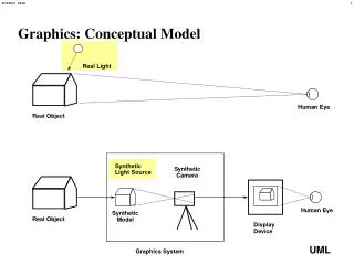
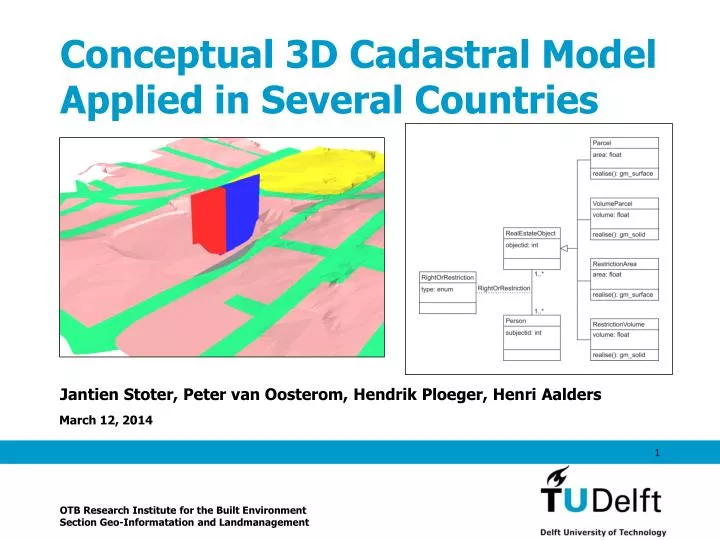
Conceptual 3D Cadastral Model Applied in Several Countries. Jantien Stoter, Peter van Oosterom, Hendrik Ploeger, Henri Aalders. OTB Research Institute for the Built Environment Section Geo-Informatation and Landmanagement. Current cadastral model. 2D parcels and 2D registration.

E N D
Conceptual 3D Cadastral Model Applied in Several Countries Jantien Stoter, Peter van Oosterom, Hendrik Ploeger, Henri Aalders OTB Research Institute for the Built Environment Section Geo-Informatation and Landmanagement
2D parcels and 2D registration
3D cadastral registration • Norway (2006?) • Sweden (from 2004) • Canada, British Colombia • Australia, Queensland
3D cadastral registration:some outcomes • No 3D property units in the geographical data set of the cadastre • The footprint of 3D property units are limited to 2D surface parcels in British Colombia • 3D property units must relate to built constructions in Norway and Sweden • No digital description of the 3D property units • 3D property units must be described in survey plans in British Colombia and Queensland
Full 3D Cadastre • a) Only 3D parcels • Rights to space, divided in well-defined (surveyed) volumes • b) Conversion of the “classic” 2D parcels into 3D parcels • The basis of the division of the earth (and space under or above the surface) is still the surface (2D) boundary
Queensland: “3D parcels” • Building parcels: defined by floors, walls, ceilings • Restricted parcels: defined (restricted) by certain level (depth or height) • Volumetric parcels: defined by volumetric parcel plan (using 3D points) • Remainder parcels: remains after the subdivision of a restricted or volumetric parcel
Parcels 100 and 101:visualisation of the 3D geometries of volumetric parcels